Break from dangerous heat arrives in Kansas City. How long will this cool weather last?
Published in Weather News
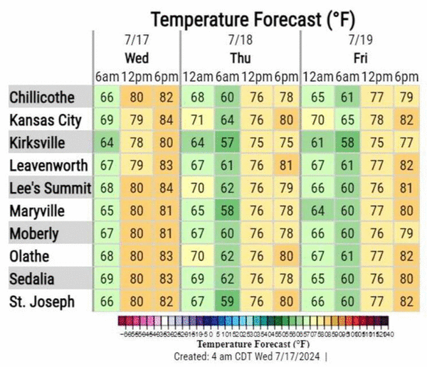
KANSAS CITY, Mo. — Cooler temperatures are expected in the Kansas City area over the next few days, giving the metro a break from the sweltering heat.
“Pleasant weather conditions are expected today and through Friday, with below normal temperatures and lower humidity,” the National Weather Service in Kansas City said on X, formerly Twitter. “Enjoy the mid-summer reprieve from the heat.”
Temperatures will be in the mid-80s on Wednesday, a welcome relief from earlier this week when temperatures were in the mid-90s.
There is a slight chance of rain in parts of the region Wednesday afternoon, mainly in eastern Kansas and far western Missouri. According to the weather service, the rain is expected to be light and short-lived.
Mainly dry and less humid conditions are expected through the rest of the work week, with afternoon temperatures between five and 10 degrees below average, the weather service said in its forecast discussion.
Typically, temperatures in Kansas City are around 89 degrees this time of year.
Chances for rain return to KC weather forecast
A series of disturbances in the atmosphere are expected to move through the region, bringing the chance for rain Saturday and Sunday, the weather service said. However, because of limited instability, the potential of rain may be reduced.
The cool weather is expected to continue, with temperatures reaching the upper 70s on Saturday and Sunday.
The below-average temperatures are expected to continue into early next week.
The extended outlook indicates that near-average temperatures and rainfall are likely for July 24 through 30.
©2024 The Kansas City Star. Visit at kansascity.com. Distributed by Tribune Content Agency, LLC.


Comments