Weather
/Knowledge
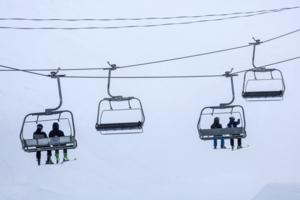
Windy wonderland: Gusty conditions expected at Mammoth Mountain this weekend
LOS ANGELES — It's always a good idea to bundle up at Mammoth Mountain, but anyone hoping to get in some holiday ski runs may want to consider some additional layers.
A storm forecast to hit this weekend is expected to bring strong winds with gusts of up to 70 mph at the mountain's summit, according to the National Weather Service.
A high-...Read more
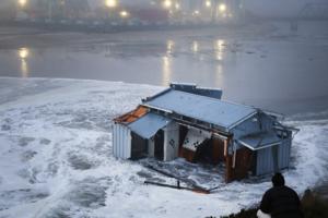
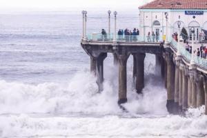
California's piers may not be able to withstand climate change
LOS ANGELES — As a series of winter storms slammed California’s coast with powerful rip currents and towering waves, part of the Santa Cruz Wharf collapsed on Monday, plunging two contractors and a city employee into the water.
The pier was one of several public wharves and piers in the state actively undergoing structural integrity ...Read more
Warmer weather, rain washes over NYC ahead of New Year's
NEW YORK — With Christmastime officially in the rearview — and the wintry chill with it for the time being — warmer weather and rain are forecast to wash over New York City in the days leading up to the New Year.
New Yorkers on Saturday woke up to fog and rain, with temperatures hovering around 40 degrees during the morning hours. The ...Read more
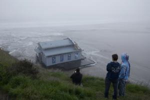
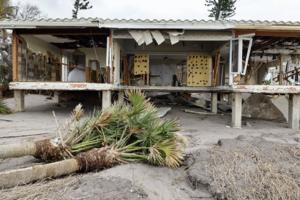
Destructive waves keep thrashing Santa Cruz: 'Mother Nature holds the cards'
To many locals, it feels like Santa Cruz's picturesque coast is being battered like never before.
Waves from strong winter storms and a pair of tsunamis have caused millions of dollars in damage to the wharf and marina area in recent years, including an onslaught of dangerous waves this week that washed almost 150 feet of its wharf out to sea. ...Read more
The bomb cyclone killed his mom in Washington. He was right next to her
LYNNWOOD, Wash. — Brian O'Connor and his mom set up the tent they were living in the day before the November bomb cyclone in the woods in Lynnwood, a spot they had never camped at before.
They had heard about the incoming storm and chose an area next to a large tree they thought would be sturdy enough to withstand the winds and cover them ...Read more
More hurricanes are slamming the Gulf Coast. Is this the new normal?
Since the turn of the century, major hurricanes hitting the U.S. have had one key feature in common.
Location.
The Gulf of Mexico coastline transformed into a bullseye for major storms, which have taken aim from Corpus Christi, Texas, to Marco Island and destroyed communities in their wake. Eighteen hurricanes reaching Category 3 strength or ...Read more
After a Christmas lull, towering waves will wallop California coast again
Stormy seas along the California coast calmed a bit for the Christmas holiday, but powerful ocean waves were expected to return to the Bay Area for the rest of the week.
Waves up to 30 feet high were expected to crash ashore in Northern California between Thursday morning and Sunday afternoon. The National Weather Service issued a high-surf ...Read more
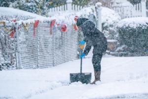
Snow covers New York City on first day of winter, frigid temps to follow
NEW YORK — Winter is here and so is the white stuff.
Snow blanketed New York City early Saturday morning, ushering in the first official day of winter in a truly frosty fashion. Flurries first started to fall across the tristate area on Friday, fluctuating between flakes and rain for much of the day before transitioning to more steady snow ...Read more
Snow covers New York City on first day of winter, frigid temps to follow
NEW YORK — Winter is here and so is the white stuff.
Snow blanketed the New York City early Saturday morning, ushering in the first official day of winter in a truly frosty fashion. Flurries first started to fall across the tristate area on Friday, fluctuating between flakes and rain for much of the day before transitioning to a more steady ...Read more
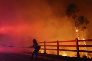
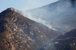
California's wild weather: Brush fires, heavy rains, flooding and even a tornado. More unstable conditions coming
LOS ANGELES — It's only mid-December and already California's weather is putting the state on high alert for winter — and it's likely far from over.
Just this past week, a major wildfire raced into Malibu, fueled by dangerous Santa Ana winds, and a powerful storm dumped feet of snow in the mountains, caused flooding in the San Francisco Bay...Read more
A first-ever tornado warning was issued for San Francisco County early Saturday as powerful winds swept through region
LOS ANGELES — A first-ever tornado warning was issued for San Francisco County early Saturday as thunderstorms and wind gusts of up to 80 mph swept through the region, officials said.
"Take shelter now in a basement or an interior room on the lowest floor of a sturdy building," a National Weather Service advisory said on social media. Parts ...Read more

Hurricane Helene may have spread invasive critters in Georgia
The devastating toll Hurricane Helene inflicted on Georgia this fall will be felt for years in hard hit parts of the state. The storm caused an estimated $5.5 billion in damage to the state’s agriculture and forestry sectors, plus billions more in property losses — and claimed at least 33 lives.
But death and destruction may not be all ...Read more
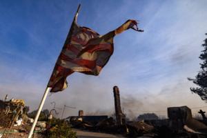
waiting for photo // Fierce Santa Ana winds topple big rig trucks in San Diego County and push the region toward drought
SAN DIEGO — San Diego County edged closer to drought Tuesday, whipped by fierce and damaging Santa Ana winds that further dried out a region that hasn’t received a long, deep soaking of rain since March.
The wind storm, which toppled big rigs on Interstate 8, fanned wildfires and canceled school in 10 rural districts, might be followed by ...Read more
Red flag warnings set to take effect throughout Southern California, beginning Monday
Red flag warnings will go into effect early Monday for large swaths of Southern California, from Los Angeles to San Diego, due to strong Santa Ana winds, according to the National Weather Service.
The strong dry winds combined with warm temperatures and low humidity will bring fire weather to the San Gabriel and Santa Monica mountains as well ...Read more

Las Vegas area's 2024 heat death toll swells to nearly 500
LAS VEGAS — Nearly 500 deaths in the Las Vegas area can be attributed to the region’s record summer, according to data released Monday by the Clark County coroner’s office.
Deaths this year where heat was a factor now total 491, though such a count is yet to be finalized as investigators close out cases in a process that takes up to 90 ...Read more
3 takeaways from the devastating 2024 hurricane season
TAMPA, Fla. — Forecasters warned in the spring to prepare for the worst this hurricane season.
They were right: Months later, the Tampa Bay area will remember the 2024 season, which ends Saturday, as one of the deadliest and most destructive in more than a century.
After a slow start to the season, Hurricane Debby drenched parts of the ...Read more

Chicago weather: Frigid weekend brings coldest weather since January
CHICAGO — With December’s arrival, bitterly cold weather is set to continue into early next week with wind chills in the single digits.
The Chicago area has not seen such chilly weather since mid-January, according to the National Weather Service. Temperatures on Saturday and Sunday nights are predicted to reach lows in the teens, according...Read more
Severe cold, snow in Midwest threaten post-Thanksgiving travel
Parts of the Great Lakes region were pummeled with almost 3 feet of snow, threatening what’s expected to be one of the busiest U.S. travel weekends on record as Americans return home from Thanksgiving holiday gatherings.
Ohio, Pennsylvania and New York were hit hard by intense snow and dangerously cold temperatures, with significant travel ...Read more
MSP: Nearly 150 Metro Detroit crashes after post-Thanksgiving snow
DETROIT — Metro Detroit had about 150 preventable vehicle crashes within the past 24 hours as post-Thanksgiving snow fell over the area, Michigan State Police announced early Saturday.
Four MSP patrol cars were struck while investigating the crashes, the MSP Second District Post wrote on X. No one was hurt.
Officials asked in a separate post...Read more
New York City hit with arctic blast, lake-snow effect to batter upstate
NEW YORK — December is nearly upon us, and it’s finally starting to feel like winter in New York.
After a damp and dreary Thanksgiving, a frigid chill swept across much of the tristate area overnight and into Friday, bringing some of the coldest temperatures the region has faced so far this year.
While highs in New York City are expected ...Read more
Popular Stories
- Windy wonderland: Gusty conditions expected at Mammoth Mountain this weekend
- Warmer weather, rain washes over NYC ahead of New Year's
- New York City hit with arctic blast, lake-snow effect to batter upstate
- A first-ever tornado warning was issued for San Francisco County early Saturday as powerful winds swept through region
- California's piers may not be able to withstand climate change
Comics