Florida Gulf Coast remains in bullseye of 'extremely dangerous' Cat 4 Hurricane Milton
Published in News & Features
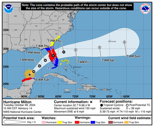
MIAMI — Hurricane Milton weakened slightly overnight but remained a formidable and growing Category 4 hurricane early Tuesday morning on a path toward a devastating landfall along Florida’s Gulf Coast.
Though the storm’s sustained winds had eased somewhat from a near-record 180 mph, it was still packing extremely powerful 145 mph winds, and the slight slackening did not reduce Milton’s biggest threat. It was expected to push up to 15 feet of life-threatening storm surge across a huge swath of the coast, anywhere between Fort Myers Beach and Cedar Key.
From there, Milton could plow a path of record-breaking damage across the state, whipping by the theme parks of Orlando before exiting along the Space Coast. Forecasters cautioned that as Milton’s wind speed falls, likely to a Category 3 before landfall sometime late Wednesday or early Thursday, the small storm will expand its size, sweeping its damaging winds across a broader area.
That threat put almost the entire state, including Miami-Dade and Broward counties and the Florida Keys, under some sort of hurricane or tropical storm warning or watch. Southeast Florida could see tropical storm force gusts beginning Wednesday afternoon through Thursday morning, with flooding rains from Milton’s outer feeder bands.
“Milton has the potential to be one of the most destructive hurricanes on record for west-central Florida,” National Hurricane Center forecasters wrote in the 5 a.m. update.
Evacuations underway
At 5 a.m., there was little change in the track overnight with the center of the National Hurricane Center’s cone of concern aimed at heavily-populated Tampa Bay, still reeling from the region’s worst storm in a century — Hurricane Helene — just two weeks earlier.
Milton, on its current track, could be far worse and highways along much of the Gulf Coast were packed late Monday as residents began one of the state’s largest evacuations. Tolls were lifted for west-central Florida as evacuations were called in 14 counties.
Jared Perdue, head of Florida’s Department of Transportation, urged residents to leave as soon as possible if they’re evacuating in a Tuesday morning press conference. Officials said traffic was up 150% on major highways, so the breakdown lanes on highways were open as extra lanes of traffic.
“Unfortunately every storm we see traffic fatalities because people wait until the last minute to leave,” he said.
To address this, Gov. Ron DeSantis said the state planned to open at least four backup shelters of last resort near highways so that drivers stuck in traffic as the storm encroaches have somewhere to go. These warehouses can hold thousands of people, he said, including up to 10,000 at one site.
Those counties are also working double-time to clear the streets of waterlogged appliances and furniture from Hurricane Helene before Hurricane Milton’s winds turn them into projectiles. The state has assigned hundreds of employees to help, and it plans to ask FEMA for permission to pay debris haulers even more to surge in from other states. However, DeSantis said, they can’t get to all of it.
“It may not have been humanly possible to have all the debris cleaned up from Helene before Milton hit, just because of how much there was,” he said.
On Tuesday morning, counties began shutting off water to barrier islands, including Siesta Key and Casey Key in Sarasota, to try and protect the water and sewer system. Pinellas County will “most likely” do the same with its sewage system, the Tampa Bay Times reported.
The governor warned residents that their window for preparations was shrinking, and everyone should be hunkered down by Wednesday morning.
“Let’s prepare for the worst and pray we get a weakening,” he said. “We must be prepared for a major, major impact on the west coast of Florida.”
Turn toward Florida begins
Milton, still about 560 miles southwest of Tampa, also began slowly gaining some latitude overnight, signaling that it may be starting its forecast turn to the northeast toward Florida. The NHC had pushed its projected landfall back slightly, possibly to the early morning hours on Thursday, but its impacts along the coast will be felt at least a day earlier.
On Monday, Milton exploded into a frightening Category 5 storm with 180 mph maximum sustained winds. Its barometric pressure — a measure of intensity — dropped to the fourth-lowest on record at one point.
“Milton has the potential to be one of the most destructive hurricanes on record for west-central Florida,” National Hurricane Center forecaster Eric Blake wrote in the 5 p.m. Monday update.
Overnight, the storm underwent an eyewall replacement cycle, where a new, larger eye forms on the outskirts of the current one and eventually replaces it. The process tamps down wind speeds temporarily but grows the wind field.
Tuesday morning satellite found a slightly bigger Milton with just a single eye again — a sign the storm is ready to strengthen again. The latest hurricane center forecast calls for it to regain Category 5 wind strength on Tuesday before storm-shredding wind shear near Florida bats it back to a Category 3 ahead of landfall.
“An expanding wind field, the angle of approach to the coast, and the formidable strength, all will lead to a deep & damaging surge in Florida,” wrote John Morales, a hurricane specialist at NBC6, on Twitter.
©2024 Miami Herald. Visit at miamiherald.com. Distributed by Tribune Content Agency, LLC.


Comments