Category 5 Hurricane Milton 'ferocious' with 180 mph winds; 15-foot storm surge projected for Florida
Published in News & Features


ORLANDO, Fla. — Hurricane Milton surged Monday into a monster Category 5 storm with 180 mph winds in the Gulf of Mexico, and is forecast to remain a dangerous major hurricane ahead of landfall on Florida’s Gulf Coast.
“Milton is a potentially catastrophic Category 5 hurricane on the Saffir-Simpson Hurricane Wind Scale,” the NHC alerted, noting it had “explosively” intensified. “While fluctuations in intensity are expected, Milton is forecast to remain an extremely dangerous hurricane through landfall in Florida.”
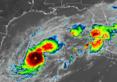
As of 8 p.m. Eastern time, the NHC said it had sustained winds of 180 mph, which is an extremely powerful Category 5 hurricane, the highest level in its wind scale. Sitting amid the warm waters of the Gulf of Mexico and low wind shear, it was located 650 miles southwest of Tampa and 60 miles northwest of Progresso, Mexico, moving east at 10 mph north of the Yucatan peninsula.
The intensity forecast projects it to grow even more, with sustained winds of 185 mph and gusts of 225 mph, but then begin to lose steam as it turns toward Florida.
Updated storm surge predictions now call for 10-15 feet from the Anclote River north of Tampa south down to Englewood, including Tampa Bay in the core projected landfall area.
“We’re talking about storm surge values higher than the ceiling,” said Florida Division of Emergency Management Director Kevin Guthrie. “Please. If you’re in the Tampa Bay area, you need to evacuate. If they have called for your evacuation order, I beg you, I implore you, to evacuate. Drowning deaths due to storm surge are 100% preventable if you leave.”
Evacuations on much of Florida’s west-coast barrier islands have already begun.
“We had situations where people died of drowning in Hurricane Ian. Had they just gone across the bridge from Estero Bay, Sanibel Island and so on, just across the bridge to the first available shelter that had capacity, they’d still be alive today,” he said.
The NHC also warns 6-10 feet could be seen from Englewood south to Bonita Beach including Charlotte Harbor, 5-10 feet from the Anclote River north to Yankeetown, 4-7 feet from Bonita Beach south to Chokoloskee, 3-5 feet from Yankeetown north to the Suwannee River and on the east coast from the Flagler/Volusia county line north to Altamaha Sound, Georgia. The NHC also forecasts 2-4 feet from Sebastian Inlet north to the Volusia/Flagler line and from Altamaha Sound north to Edisto Beach, South Carolina, the Dry Tortugas and St. Johns River.
Hurricane Milton is forecast to turn toward the east-northeast on Tuesday and Wednesday and approach Florida’s Gulf Coast by Wednesday night.
“The storm has moved a little slower than projected, but remember, don’t get wedded to the cone,” said Gov. Ron DeSantis on Monday afternoon. “There will be impacts far outside the cone, and these cones can shift, and so there’s not an approximation that you can hang your hat on about where this storm is actually going to make landfall. All folks on the west coast of the Florida peninsula should be prepared for potential major impacts.”
DeSantis warned that this storm has been exceeding the predictions thus far, so stay vigilant.
“There’s a lot of uncertainty about what is going to happen in terms of this track. It is predicted that this will weaken, but, you know, it was not predicted it would get this strong to begin with,” he said. “So we can hope and pray that it does weaken. But as of right now, this is a ferocious hurricane.”
Evacuation efforts have congested highways to the point the state has dropped all tolls in west and Central Florida and Alligator Alley. It has also opened up the shoulders on sections of Interstate 4 and 75, cleared by the state Department of Transportation, to assist in the evacuation.
“Right now, the usage on I-75 is about 90% more than what would typically be happening right now,” DeSantis said. “Just be prepared that there are a lot of people on the roads right now. You’ve got time. … It’s not as if the storm is going to come tonight, but FDOT is doing what they can to ameliorate that and to be able to keep things moving as best as possible.”
“This is not a good situation. It is a very serious situation,” said National Weather Service Director Ken Graham. “We’ve got aircraft, both at NOAA and the hurricane hunters at the Air Force constantly in this storm to get us the latest readings as we track intensification. Things change real quick on us.”
He said he expects the wind field to expand as it approaches the coast.
“I really want to urge everybody, this is really important. I’ve seen this before,” he said. “Even if you have fluctuations in the maximum wind speed, because the winds come down a little bit before landfall, we’re still talking a major hurricane. Expect the wind field to expand. That means more storm surge and more areas that could see the significant wind damage.”
It had rapidly grown from a tropical storm with 50 mph winds Sunday morning to a Category 5 hurricane increasing 130 mph in intensity in just under 36 hours.
“By tomorrow, its intensity should be dictated by any eyewall replacement cycles, which will likely cause the system to gradually weaken but grow larger,” said NHC senior hurricane specialist Eric Blake.
For now the system has a tight wind field with hurricane-force winds out to 30 miles and tropical-storm-force winds out to 80 miles.
“Milton’s remarkable rapid intensification is continuing. Satellite images show a small eye within the very cold central cloud cover, and the eye is becoming better defined,” Blake said.
He noted only Hurricane Wilma in 2005 and Hurricane Felix in 2007 had more rapid intensification among NHC records.
Colorado State University meteorologist Phil Klotzbach said this is the latest in the calendar year ever for a Category 5 hurricane with at least 175 mph winds on record. He said it was the strongest in the Gulf of Mexico since 2005’s Hurricane Rita.
It’s also only the second October Category 5 hurricane in the satellite era since 1966, he said, after 2018’s Hurricane Michael.
Its path is expected to shift to the east and then northeast on Tuesday and Wednesday headed up toward Florida’s Gulf Coast within a cone that has also shifted north since earlier Monday.
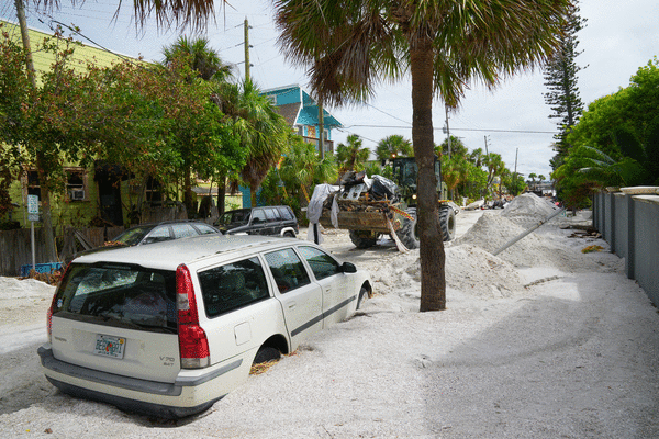
It now stretches from near Fort Myers Beach north to the Big Bend near Horseshoe Beach, but still potentially targets landfall near Tampa Bay by Wednesday, hitting an area that just endured major surge and damage from Hurricane Helene less than two weeks ago.
Its forecast intensity is expected to be dialed back by landfall, but still at Category 3 strength by 7 p.m. Wednesday just offshore with 125 mph sustained winds and 155 mph gusts.
The Federal Emergency Management Agency announced President Biden had authorized FEMA to coordinate all disaster relief efforts in the state and approved 75% federal funding for emergency protective measures including direct federal assistance to 37 counties that were part of Gov. Ron DeSantis’ original emergency declaration request, and the same level limited to direct federal assistance to an additional 14 counties.
“The president has approved what we asked for. We’re thankful for that,” DeSantis said Monday afternoon. “If there’s something we need that they don’t approve, I will not hesitate to call him. We want to use whatever resources are available to be able to help Floridians prepare and respond to this storm. But everything we’ve asked for from President Biden, he has approved, and we do think we’ll get more approvals for some of the individual assistance and the debris removal after landfall.”
DeSantis said at a briefing Monday morning from Tallahassee that the storm has slowed so might make landfall late Wednesday or early Thursday.
“We don’t know exactly how it’s going to go. I know they say the eye is going to go here or here — that can move. When you’re talking about 30, 40, 50 miles north or south, that will make a huge difference in terms of who gets the worst surge, how much power is ended up taken out, and so we have no way of knowing how that’s going to shake out,” he said. “So the resources are being brought in, and the power restoration effort will begin as soon as it’s safe to do so.”
“We also have a storm that’s already very powerful now, the forecasts are that it’s going to peak before it reaches landfall, and then weaken. It is still going to be a strong storm,” DeSantis said. “We don’t know that that’s necessarily going to happen, and so this is something that’s going to be really, really significant one way or another.”
“The system is still likely to be a large and powerful hurricane at landfall in Florida, with life-threatening hazards along portions of the the coastline,” NHC senior hurricane specialist Jack Beven said.
In Florida, a hurricane warning is in effect for the west coast from Bonita Beach north to the mouth of the Suwannee River including Tampa Bay, and a hurricane watch for the Dry Tortugas, Lake Okeechobee, the Gulf coast from Chokoloskee to south of Bonita Beach and from the Florida east coast from the St. Lucie/Indian River county line north to the mouth of the St. Mary’s River in Georgia.
Inland hurricane warnings are in place for parts of the southern Florida peninsula including Central Florida’s Lake, Marion, Orange, Osceola, Polk, Seminole and Sumter counties, while Brevard and Volusia counties remain under hurricane watches.
A tropical storm warning is in effect for all of the Florida Keys and Dry Tortugas, Lake Okeechobee, the Gulf coast from Flamingo to south of Bonita Beach and from north of the mouth of the Suwannee River to Indian Pass. A tropical storm watch is in place for the Florida east coast south of the St. Lucie/Indian River county line south to Flamingo and on the Georgia and South Carolina coast from north of the St. Mary’s River to the South Santee River.
A storm surge warning is in effect for the Gulf coast from Flamingo north to the Suwannee including Charlotte Harbor and Tampa Bay. A storm surge watch is in place on Florida’s east coast from the Sebastian River north to Edisto Beach including the St. Johns River.
In Mexico, a hurricane warning is in effect for Celestun to Rio Lagartos and hurricane watch from Rio Lagartos to Cabo Catoche and from Campeche to south of Celestun. A tropical storm warning is in effect for Rio Lagartos to Cancun and from Campeche to south of Celestun.
Rainfall also is forecast to dump 5-10 inches across much of the state, with some areas getting as much as 15 inches.
While the intensity may fall just before landfall, the wind shear will be pushing stronger winds farther east.
“Vertical wind shear is forecast to markedly increase as Milton approaches Florida, and some weakening is anticipated,” Blake said. “However, the regional hurricane models are showing the system growing even if it weakens, and we are expecting Milton to be a large hurricane at landfall, with very dangerous impacts spread out over a big area.”
The system is expected to lose intensity as it crosses the peninsula, but the projected path has it never losing hurricane strength.
“It isn’t like it’s just going to be a rainstorm,” DeSantis said. “I mean, all the way until it exits the state is going to be powerful so please take the appropriate precautions, listen to your local officials, and we’ll get through this. We’ll respond very quickly, but, but this does have the potential to have a lot of damage.”
The debris leftover from Helene poses a major risk, he said.
His state declaration ordered all landfills and similar sites to be open 24 hours to deal with the massive amounts of debris leftover from Hurricane Helene.
“We had a lot of debris left from Hurricane Helene on Florida’s Gulf Coast that creates a huge hazard if you have a major hurricane hit in that area this week,” he said. “So we’ve marshaled state assets to be able to help with that mission, and we’re going to continue to do that until it’s no longer safe to do so.”
He said just in the last 24 hours, the state in one of the hardest-hit areas has removed almost 500 truckloads totaling more than 9,000 cubic yards of debris.
“That’s just from the barrier islands in Pinellas County, bringing to the debris landfills. We have over 200 state assets, dump trucks, other types of trucks and vehicles, but keeping it 24/7, is important,” he said.
DeSantis had declared a state of emergency for 51 of the state’s 67 counties, up from 34 declared on Saturday.
The updated list includes Alachua, Baker, Bradford, Brevard, Broward, Charlotte, Citrus, Clay, Collier, Columbia, DeSoto, Dixie, Duval, Flagler, Gilchrist, Glades, Hamilton, Hardee, Hendry, Hernando, Highlands, Hillsborough, Indian River, Lafayette, Lake, Lee, Levy, Madison, Manatee, Marion, Martin, Miami-Dade, Monroe, Nassau, Okeechobee, Orange, Osceola, Palm Beach, Pasco, Pinellas, Polk, Putnam, Sarasota, Seminole, St. Johns, St. Lucie Sumter, Suwanee, Taylor, Union, and Volusia counties.
“Put your hurricane preparedness plan in place, make sure your gas tanks are filled,” DeSantis said on Sunday. “Make sure you have enough water and nonperishable food to last you as long as the power may be out, clear up loose objects in your yard. Obviously, the big debris piles, you need that to get hauled away. But anything other than that that isn’t debris,” he said.
Impacts on Florida will include storm surge and heavy rains with 5-10 inches and some areas up to 15 inches forecast for portions of the Florida peninsula and Florida Keys through Wednesday night.
“This rainfall brings the risk of flash, urban, and areal flooding, along with minor to isolated moderate river flooding,” the NHC stated.
Much of the state including all of Central Florida remains under a flood watch from Sunday though Thursday, according to the National Weather Service.
“Excessive runoff may result in flooding of rivers, creeks, streams, and other low-lying and flood-prone locations,” the NWS advisory states. “Flooding may occur in poor drainage and urban areas.”
In addition, swells generated by the system will begin to hit the southwestern Gulf of Mexico coast today, spreading to the north and east by early next week.
The National Weather Service in Melbourne says tropical-storm-force winds could arrive Wednesday morning for Central Florida, with the center of the storm hitting the coast late Wednesday afternoon or early Wednesday evening, making its way across the I-4 corridor and emerging off the east coast before daybreak Thursday.
“Deteriorating weather conditions are forecast in the form of heavy rainfall and increasing gusty winds, especially rainbands,” said NWS meteorologist Tim Sedlock. “A few tornadoes will also be in play on Wednesday.”
“The time is now to enact your local hurricane plan and ensure you have supplies, and everything else necessary to ride out this storm,” Sedlock said.
The NHC also is keeping track of two hurricanes in the Atlantic.
As of 11 a.m. Monday, what had been Hurricane Kirk became Post-Tropical Cyclone Kiri, and was located about 6,555 miles west-northwest of the Azores, moving northeast at 29 mph with sustained winds of 75 mph.
It had earlier this week reached Category 4 level, becoming the season’s third major hurricane ahead of Milton.
Hurricane-force winds extend out up to 90 miles and tropical-storm-force winds extend out up to 310 miles from its center, with it approaching Europe by Wednesday.
Despite its distance across the Atlantic, swells from Kirk continue to hit the east coast of Florida and elsewhere this weekend, bringing life-threatening surf and rip current conditions.
As of 5 p.m. Monday, Hurricane Leslie was located about 1,186 miles west of the southernmost Cape Verde Islands moving northwest at 14 mph with maximum sustained winds of 80 mph, which makes it a Category 1 hurricane.
“This general motion is expected to continue over the next few days,” forecasters said. “Gradual weakening is forecast during the next several days.”
Hurricane-force winds extend out up to 15 miles and tropical-storm-force winds extend out up to 105 miles from its center.
The NHC also has its eyes on a tropical wave expected to move off the west coast of Africa in the next few days and a system that has been dropping rain over South Florida on Monday.
The Florida system, which is not related to the approaching hurricane, is an area of disturbed weather located also over the Florida Straits and the northwestern Bahamas that is expected to move northeast where it could form into an area of low pressure near the northwestern Bahamas.
“Some additional tropical or subtropical development is possible while the low moves northeastward to east-northeastward around 15 mph,” forecasters said. “However, upper-level winds are likely to increase by Wednesday, which should limit any further development after that time.”
The NHC gives it a 20% chance of development in the next two to seven days.
The tropical wave off of Africa is forecast to move into the far eastern Atlantic in a couple of days.
“Afterward, environmental conditions appear only marginally favorable for some limited development of this system while it moves westward or west-northwestward across the eastern tropical Atlantic, crossing the Cape Verde Islands on Thursday or early Friday,” forecasters said.
The NHC gives it a 20% chance to develop in the next seven days.
The 2024 Atlantic hurricane season has had 13 named storms including nine hurricanes, four of which grew to major hurricane strength, and four tropical storms.
Hurricane season runs from June 1-Nov. 30.
_____
©2024 Orlando Sentinel. Visit at orlandosentinel.com. Distributed by Tribune Content Agency, LLC.


Comments