Rivers cresting in parts of metro area, as federal aid is approved for 22 Minnesota counties
Published in News & Features
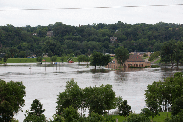
MINNEAPOLIS — Swollen rivers in St. Paul and the southwest metro area were beginning to crest Saturday and should then start to drop, at least until another round of rain arrives on Monday, according to the National Weather Service.
As of Saturday, the Mississippi River at St. Paul had held steady at around 20 feet for almost a day and was not expected to go higher, according to Tyler Hasenstein, a Weather Service meteorologist. At 20.17 feet, the river's height qualifies as the eighth-highest level on record.
At Jordan, the Minnesota River swelled to 35.12 feet on Friday morning, just barely knocking off the prior record mark of 35.1, set in 1965. At Savage, the Minnesota stayed just under the level at which water would begin to cover a lane of Highway 101.
Another influx of rain starting on Monday could keep rivers high, or in some cases push smaller rivers that have started to drain back into flood stage, Hasenstein said. Areas of concern were mostly in southwest Minnesota along the Le Sueur and Blue Earth rivers, he said; additional flooding which take between five and seven days to affect the Mississippi, which eventually drains both rivers.
But many areas were already grappling with costly damage or closures after an unusually wet start to summer. Roughly a whole summer's worth of rain fell in a monthlong period from late May into June, Hasenstein said.
That water will continue to travel down the Mississippi, where in some areas the river has not yet crested. The river was expected to rise another 6 inches at Hastings, according to the Weather Service.
Some disaster relief was on the way. On Saturday, Gov. Tim Walz' office announced that the Federal Emergency Management Agency has approved a disaster declaration for 22 Minnesota counties affected by flooding over the past two weeks. The declaration is the first step in reimbursing communities for emergency efforts like debris removal and temporary flood barriers.
"I've seen the damage across our state firsthand — it's going to take a united effort at every level of government to quickly rebuild and recover. This assistance is going to make all the difference in that recovery," Walz said in a statement.
The declaration covers much of southern Minnesota. Some of the most extreme damage has occurred in Blue Earth County, where the Blue Earth River carved a new path around the century-old Rapidan Dam. A house near the dam fell into the river, and a store would have followed had it not been removed by the county Friday.
An email sent out Saturday by Blue Earth County said that officials were placing rip-rap along the County Road 9 bridge, which is next to the dam.
Also covered in the federal disaster declaration are parts of northeastern Minnesota, which faced its own round of flash flooding that washed out roads and inundated the small town of Cook earlier this month.
©2024 StarTribune. Visit startribune.com. Distributed by Tribune Content Agency, LLC.


Comments