Category 4 Hurricane Beryl makes landfall in the east Caribbean with 150 mph winds
Published in News & Features
MIAMI — Hurricane Beryl slammed into the eastern Caribbean Islands as a fast-moving Category 4 storm on Monday, a fast, hard punch to an island chain that rarely sees storms of that magnitude, especially this early in the season.
The historic early-season whopper of a storm ripped off roofs, toppled trees and shut down power on Grenada’s tiny Carriacou Island, where it made landfall around 11 a.m. Eastern time, and nearby islands, many of which were under hurricane and tropical storm warnings. It roared through with 150 mph sustained winds, the high end of Category 4, and brought rain and 6 to 9 feet of storm surge.
“It’s bad and we have not seen the worst yet. The next few hours are going to be worse,” St. Vincent and the Grenadines Prime Minister Ralph Gonsalves told the Miami Herald in an interview around noon Monday. “As it reaches close to us, we will be getting the full effect of the hurricane.”
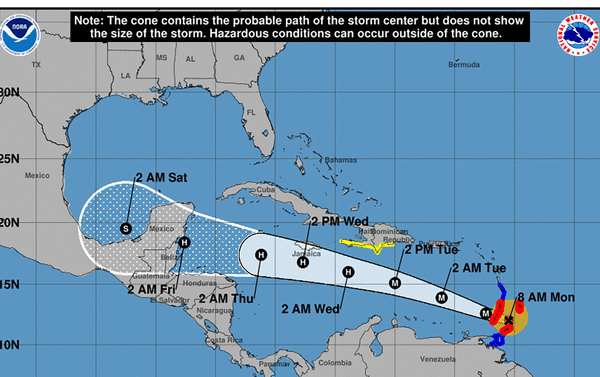
By Monday afternoon, Beryl’s eye was clear of the island chain and bound for a close potentially destructive brush with Jamaica. It was on a track with sea surface waters so hot they’re running at average September temperatures, as well as a pocket of friendly, storm-aiding winds.
The National Hurricane Center said the storm had another 24 hours or so of runway ahead, where it could potentially strengthen even further and break more records. Although the forecast does not explicitly call for Beryl to strengthen to a Category 5, the hurricane center said “some intensity fluctuations are possible in the near term.”
However, there was some small encouraging news for Jamaica. Forecasters noted that around Tuesday afternoon atmospheric conditions in the form of stronger wind shear could weaken Beryl down to Category 2 or 3 by the time its eye passes south of the heavily populated island on Wednesday.
Several shifts over the day on Monday nudged the potential track of Beryl’s eye close to Jamaica, which issued a hurricane watch for the island, and the southern coast of Haiti and the Dominican Republic, which upgraded their tropical storm watches to warnings Monday evening.
As of a 5 p.m. update, Beryl’s eyewall was about 125 miles northwest of Grenada, and the storm was heading west-northwest at 21 mph with sustained winds near 150 mph.
Early Monday, hurricane hunter planes swooped over the roiling storm and found it in the final stages of an eyewall replacement cycle, where a bigger, stronger eye emerges and dwarfs the previous one. Storms typically weaken a bit during the replacement cycle but some emerge stronger on the other side, as Beryl did.
Overnight, during the replacement cycle, the slightly weakened Beryl grew its wind field substantially, increasing its reach for storm surge and wind effects in the eastern Caribbean. As of 5 p.m., tropical storm-force winds extended 40 miles from the center, and hurricane-force winds extended up to 125 miles out.
...continued
©2024 Miami Herald. Visit at miamiherald.com. Distributed by Tribune Content Agency, LLC.


Comments