Hurricane center tracking 4 systems with chance of formation
Published in Weather News
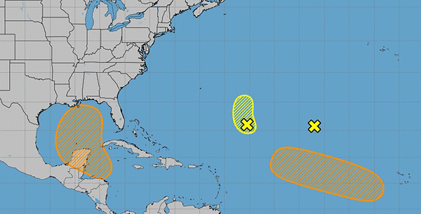
ORLANDO, Fla. — The National Hurricane Center on Saturday is tracking three systems in the Atlantic and one Gulf-bound system.
As of the NHC’s 2 p.m. tropical outlook, the most likely would come from a system expected to form in the northwestern Caribbean and move into the Gulf of Mexico.
The broad area of low pressure is likely to form by the early to middle part of next week over the far northwestern Caribbean Sea and adjacent portions of Central America.
“Thereafter, gradual development of this system is possible, and a tropical depression could form as the system moves slowly to the north or northwest over the northwestern Caribbean Sea and across the Gulf of Mexico through the end of next week,” forecasters said.
Regardless of development, this system is expected to produce heavy rains over portions of Central America during the next several days.
The NHC gives the system a 60% chance of development over the next seven days.
The NHC is also tracking three other systems in the Atlantic.
One is an area of low pressure associated with remnants of what had been Tropical Storm Gordon that continued to produce disorganized showers and thunderstorms sheared away from the low’s center by upper-level winds located more than 1,000 miles southwest of the Azores.
“Development of this system is not expected while it moves slowly northwestward over the central subtropical Atlantic during the next couple of days,” forecasters said.
The NHC gives it a 0% chance to develop in the next two to seven days.
Farther east in the central and western subtropical Atlantic was another area of low pressure about 700 miles southeast of Bermuda with disorganized showers and a few thunderstorms.
“Development is not expected while it moves generally northward at 5 to 10 mph over the central subtropical Atlantic” forecasters said.
The NHC gives it a 10% chance to develop in the next two to seven days.
A tropical wave is expected to move westward from the coast of Africa on Sunday or Monday. Gradual development of this system is possible next week as it moves west-northwestward over the eastern and central tropical Atlantic.
The NHC gives it a 40% chance to develop in the next seven days.
The 2024 Atlantic hurricane season has produced seven named storms with Helene next on the list.
Forecasters at Colorado State University, that have been putting together two-week outlooks this season, expect more activity at the end of the month.
Hurricane season runs from June 1-Nov. 30, but the height of storm production runs from mid-August into October.
______
©2024 Orlando Sentinel. Visit orlandosentinel.com. Distributed by Tribune Content Agency, LLC.


Comments