Weather
/Knowledge
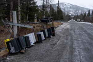
Anchorage power outages extend to 3rd day in wake of 'extreme' warm January storm
ANCHORAGE, Alaska — Hundreds of Anchorage residents remained without power for a third day following a rare January storm that brought record warmth and hurricane-force winds over the weekend.
Chugach Electric Association said the extensive repairs necessitated by Sunday's storm means some members may not get power back until Wednesday.
The ...Read more
Colorado to double arsenal of mountainside avalanche blasters in war against highway-covering snow slides
DENVER — Colorado transportation officials plan to nearly double the number of remotely controlled avalanche blasters installed on mountain ridges above highways, a project estimated to cost taxpayers tens of millions of dollars to prevent potentially catastrophic snow slides.
They’ve settled on a strategy of firing these blasters at night ...Read more
Denver weather: “Arctic” cold headed for city, windchill temps to hit 30 below zero
DENVER — Bundle up, Colorado! Subzero temperatures, wind and snow are headed for Denver this weekend, according to the National Weather Service.
Light snow was already falling in northern Colorado’s mountains on Tuesday morning, NWS forecasters said. That snow is expected to make its way into Denver and across the Eastern Plains on Friday, ...Read more

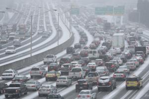
Hundreds of Delta flights canceled Saturday, long lines and crowds fill Atlanta airport
Atlanta-based Delta Air Lines canceled more than 370 flights Saturday, and long lines of travelers waiting to go through security stretched through Atlanta's Hartsfield-Jackson International Airport’s domestic terminal and baggage claim areas.
The disruptions were the fallout of Delta’s struggles during a Friday winter storm at its Atlanta ...Read more

Local governments in Georgia say they have learned from 'snowpocalypse'
ATLANTA — More than two inches of snow fell in metro Atlanta on a Friday in January, 11 years ago. It began late in the morning, when hundreds of thousands of students were in schools and many of the region’s 2.6 million workers were in their places of employment.
And on that day — Jan. 28, 2014 — almost everyone tried to go home around...Read more
Winter storm to bring more snow to Kansas City
Snow is now expected to reach the Kansas City metro from a winter storm pushing across the southern United States overnight Thursday, according to the National Weather Service.
While initial forecasts indicated the metro would likely only see a dusting with minimal overall impacts, the weather service reported that Kansas City’s chance of ...Read more
Georgia Gov. Brian Kemp issues state of emergency ahead of Friday's winter storm
ATLANTA — Gov. Brian Kemp has issued a state of emergency ahead of the severe winter weather expected to start in metro Atlanta in the overnight hours, though forecasts are now calling for less snow to reach the area.
Still, freezing temperatures could lead to slick, hazardous road conditions.
The state of emergency, which coincides with one...Read more
Local governments in Georgia say they have learned from 'snowpocalypse'
ATLANTA — More than two inches of snow fell in metro Atlanta on a Friday in January, 11 years ago. It began late in the morning, when hundreds of thousands of students were in schools and many of the region’s 2.6 million workers were in their places of employment.
And on that day — Jan. 28, 2014 — almost everyone tried to go home around...Read more
Winter storm watch issued, snow expected in metro Atlanta later this week
ATLANTA — The National Weather Service has issued a winter storm watch for Friday morning as North Georgia and metro Atlanta brace for snow later this week.
“Expect significant accumulations of snow, sleet and freezing rain that will lead to hazardous travel conditions,” the agency warned Wednesday morning.
The winter storm watch will be...Read more
Unusual 'life-threatening and destructive' winds bring risk of winter fires, power outages to Southern California
LOS ANGELES — By January, Southern California usually has experienced enough rain that a major winter wind event does not bring fears of a major fire.
But not this year.
More than eight months without any measurable rainfall, Southern California officials are gearing up for what is expected to be a "life-threatening and destructive" ...Read more
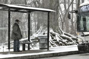
Baltimore weather: Increased snowfall expected with up to 11 inches possible in some parts of Maryland
Latest weather data shows that Anne Arundel and other southern and central counties could see 9 to 11 inches of snow Monday as meteorologists predict the heaviest portion of the storm to pass over Central Maryland — prompting increased snowfall predictions statewide.
Baltimore’s expected 4- to 6-inch prediction was increased to 6 to 9 ...Read more

'Major impact': Beshear says much of Kentucky faces potential for damaging winter storm
LEXINGTON, Ky. — Gov. Andy Beshear declared a state of emergency Saturday and activated the Kentucky National Guard as the state faces snow and ice followed by bitter low temperatures.
The National Weather Service has placed about two-thirds of the state under a winter storm warning, and the rest is under either a winter advisory or watch.
...Read more
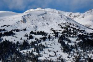
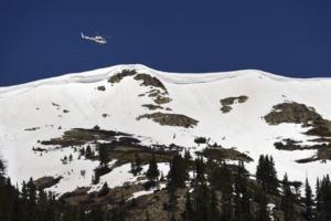
'Dangerous' avalanche conditions in Colorado mountains prompt New Year's Day warning to tread carefully
DENVER — The Colorado Avalanche Information Center is cautioning backcountry travelers to tread carefully across Colorado mountains on New Year’s Day and throughout the weekend amid “dangerous” avalanche conditions.
“We’re less likely to see heavy snowfall the rest of the week, but we are still very worried about an avalanche ...Read more
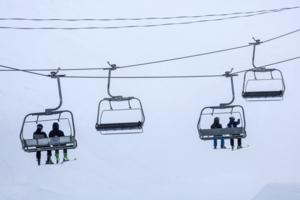
Windy wonderland: Gusty conditions expected at Mammoth Mountain this weekend
LOS ANGELES — It's always a good idea to bundle up at Mammoth Mountain, but anyone hoping to get in some holiday ski runs may want to consider some additional layers.
A storm forecast to hit this weekend is expected to bring strong winds with gusts of up to 70 mph at the mountain's summit, according to the National Weather Service.
A high-...Read more
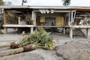
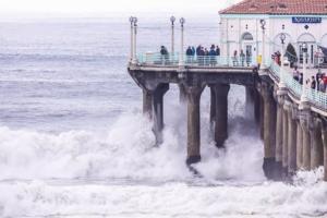
California's piers may not be able to withstand climate change
LOS ANGELES — As a series of winter storms slammed California’s coast with powerful rip currents and towering waves, part of the Santa Cruz Wharf collapsed on Monday, plunging two contractors and a city employee into the water.
The pier was one of several public wharves and piers in the state actively undergoing structural integrity ...Read more
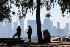
Warmer weather, rain washes over NYC ahead of New Year's
NEW YORK — With Christmastime officially in the rearview — and the wintry chill with it for the time being — warmer weather and rain are forecast to wash over New York City in the days leading up to the New Year.
New Yorkers on Saturday woke up to fog and rain, with temperatures hovering around 40 degrees during the morning hours. The ...Read more
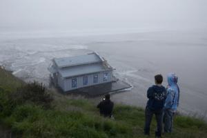
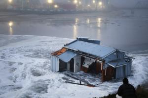
Destructive waves keep thrashing Santa Cruz: 'Mother Nature holds the cards'
To many locals, it feels like Santa Cruz's picturesque coast is being battered like never before.
Waves from strong winter storms and a pair of tsunamis have caused millions of dollars in damage to the wharf and marina area in recent years, including an onslaught of dangerous waves this week that washed almost 150 feet of its wharf out to sea. ...Read more
The bomb cyclone killed his mom in Washington. He was right next to her
LYNNWOOD, Wash. — Brian O'Connor and his mom set up the tent they were living in the day before the November bomb cyclone in the woods in Lynnwood, a spot they had never camped at before.
They had heard about the incoming storm and chose an area next to a large tree they thought would be sturdy enough to withstand the winds and cover them ...Read more
More hurricanes are slamming the Gulf Coast. Is this the new normal?
Since the turn of the century, major hurricanes hitting the U.S. have had one key feature in common.
Location.
The Gulf of Mexico coastline transformed into a bullseye for major storms, which have taken aim from Corpus Christi, Texas, to Marco Island and destroyed communities in their wake. Eighteen hurricanes reaching Category 3 strength or ...Read more
After a Christmas lull, towering waves will wallop California coast again
Stormy seas along the California coast calmed a bit for the Christmas holiday, but powerful ocean waves were expected to return to the Bay Area for the rest of the week.
Waves up to 30 feet high were expected to crash ashore in Northern California between Thursday morning and Sunday afternoon. The National Weather Service issued a high-surf ...Read more
Popular Stories
- Denver weather: “Arctic” cold headed for city, windchill temps to hit 30 below zero
- Colorado to double arsenal of mountainside avalanche blasters in war against highway-covering snow slides
- Anchorage power outages extend to 3rd day in wake of 'extreme' warm January storm
- Local governments in Georgia say they have learned from 'snowpocalypse'
- Hundreds of Delta flights canceled Saturday, long lines and crowds fill Atlanta airport
Comics