A 'transformed' beach on the Rickenbacker reopens seven years after Hurricane Irma
Published in News & Features
MIAMI — When Hurricane Irma slammed into Miami’s Rickenbacker Causeway in 2017, it nearly wiped out a narrow, shady roadside beach popular with locals for its panoramic views of Brickell and Biscayne Bay.
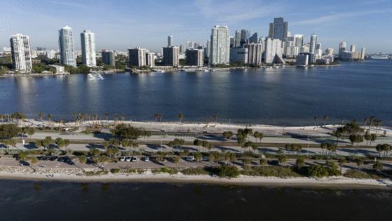
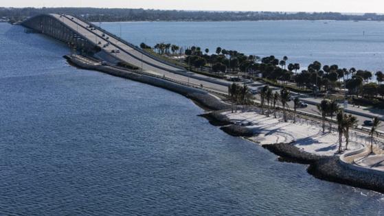
Seven years after Miami-Dade County shut it down as a safety hazard, the modest park with outsized views has finally reopened on the north and eastern flanks of North Hobie Island — a mere spit of land along the causeway between mainland Miami and the big William Powell Bridge to Virginia Key.
And thanks to a painstaking $14 million restoration, the beach has been fully transformed from afterthought to picture-perfect tableau.
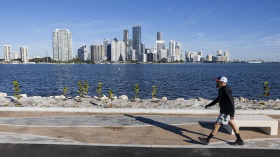
Where there was once a rough, badly eroded strip of rocky shoreline there’s now an undulating sandy beach, accessible through entryways designed to accommodate visitors with disabilities.
Gone are the 160 towering Australian pines that once gave the spot cool, ample cover from the sun. The invasive casuarina trees, popular with beachgoers but ecologically noxious and heavily damaged by Irma, have been replaced by a landscape of 263 native saltwater-resistant trees, palms and shrubs — far less shady, but more environmentally appropriate, sustainable and viewer-friendly, county engineers say.
To better resist storm surge and sea-level rise and reduce erosion, the entire park, nearly 10 acres of land in total, was raised up to three feet and wrapped in taller, concealed seawalls and white rip-rap. The barriers better protect both the new park and the causeway itself.
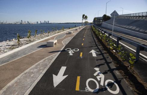
Separated paths for people on bikes and people on foot traverse a course of just under a mile along the new shoreline, sometimes just inches from the clear baywater. The trails loop around from the south side beach under the Powell bridge to the start of the low bridge to mainland Miami (where there isn’t nearly enough headroom for a connecting path back to the south side).
Beneath it all lies a new stormwater management and treatment system designed to handle increased rainfall and separate out pollutants such as oil before they can enter the bay.
The new beach, county engineers say, fills a dual role: It safeguards both the roadway and the bay’s sensitive environment, and it’s now a pretty, safe and convenient place to visit as well.
“It completely transformed an area that was derelict for some time,” said Miami-Dade transportation and public works interim director Josiel Ferrer-Diaz, whose department oversaw the restoration. “It had to be a resilient infrastructure asset, but also a community asset.”
The complexity of the project and the need for extensive environmental review and multiple permits from different agencies was one reason the beach was closed so long, Ferrer-Diaz said. But Irma was chiefly to blame, he said.
The restoration had been in the planning stages before Irma hit. But the storm eroded a shoreline that had already been receding and made the ground rougher and more uneven than it was before, making it unsafe for visitors to tread. That meant the county had to close the beach long before it had planned to, while it accelerated the restoration project, Ferrer-Diaz said.
Construction was also a complicated undertaking.
It required raising seawalls to a height of 10 feet, the stormwater system installation and the extension of the shoreline by as much as 15 feet to the island’s original contours at the time the causeway was built in the 1940s, said Ryan Fisher, the county bridge engineering manager who supervised the restoration project.
Permeable pavers cover a new parking lot and pedestrian pathway, while two types of mined sand were deposited along the shoreline to create a true beach where there had been none previously, he noted.
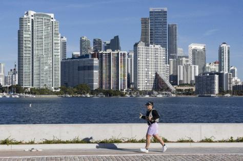
Though it officially opened just this week, the restored beach park is already being discovered by runners and cyclists — and at least one exotic iguana.
One recent weekday afternoon saw people fishing at the Powell bridge underpass (fishing is allowed), a man in a business suit sitting on one of its new square concrete benches and taking in the vista of bay and downtown skyline beyond, and that iguana hissing at passersby as it slithered into an opening in the new rip-rap.
Tom Burton, a veteran cycling-safety advocate with the Everglades Bicycle Club, slowly pedaled the new, bi-directional asphalt bike path for the first time after riding up from his home near the Falls shopping center.
Burton, 80, approved of what he saw.
“It’s very scenic,” said Burton, a retired airline pilot who has been working for years to support another long-delayed trail, the promised but only partially built greenway connecting Everglades and Biscayne national parks across South Miami-Dade. “I like parks and places that have bike paths.”
Burton also noted that the Hobie Island park seems relatively quiet and peaceful in spite of the busy causeway traffic rushing by a few yards away.
On his Miami Bike Scene blog, the often skeptical cycling advocate Rydel Deed enthusiastically wrote that the new, “beautifully restored park” represents “a big upgrade” from what was there before.
“We encourage you to come experience the renovations for yourself today!” Deed wrote.
The debut of the new beach park comes as the county’s transportation and public works department puts the finishing touches on an also-delayed master plan that will guide improvements to the Rickenbacker over the next 20 years.
The Hobie beach project was designed to mesh with any potential changes to the causeway resulting from the master plan, the county said.
The plan, which the agency said should be ready for Miami-Dade Commission review and approval by the end of April, will cover not just environmental and road-safety improvements but also promised enhancements to its recreational facilities, including beach parks, shared paths and the on-road bike lanes that have seen multiple cyclists fatally struck by motorized vehicles.
The Hobie beach restoration also included a refurbished on-road bike lane alongside it, now painted green to match the rest of the cycling-only lanes along the causeway and Crandon Boulevard on Key Biscayne.
But that also raises a couple of potential safety concerns for the cyclists who use the popular lanes. The entryway to the renewed beach park, designated by hash-like markings, means cars will be crossing the lane to enter its parking area. Cars are supposed to yield to bikes but often don’t.
In addition, the reopening of the Hobie Beach North park also will mean partially restored automobile traffic beneath the Powell Bridge overpass from the south side parking area and back to the westbound causeway lanes.
That access road had been closed to autos since two cyclists riding east in the designated lane leading from Miami to the Powell were hit and killed at the foot of the bridge by a motorist who failed to yield while cutting in from the causeway car lanes in 2022.
That auto entry point was closed and the bike lane shielded by plastic posts in the aftermath, and will remain closed even with the Hobie beach park restoration, the county engineers said.
But cars traveling on the westbound access road to the causeway lanes at the bridge’s westbound end will again be crossing the bike lane after a stop sign at a point where cyclists are coming off the bridge at high speed. That has been a trouble spot in the past because motorists would park along the access road and in the bike lane to take photos and hang out, especially after the park was closed.
The county highway officials said they will ask police and park rangers to increase monitoring and enforcement at that spot.
The master plan will also touch on the planned replacement of the aging Bear Cut Bridge connecting Virginia Key and Key Biscayne, though that will be the subject of a separate study, the county engineers said. Recent work to shore up the bridge’s pilings will extend its lifespan for another 10 years, they said.
©2024 Miami Herald. Visit at miamiherald.com. Distributed by Tribune Content Agency, LLC.





Comments