Hurricane center ups odds for Caribbean system, tracks 2 more
Published in News & Features
ORLANDO, Fla. — That National Hurricane Center increased odds a Caribbean system will form while also starting to track to more systems with potential to become the season’s next tropical depression or storm.
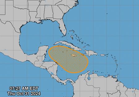
As of the NHC’s 2 p.m. tropical outlook, it said a broad area of low pressure is likely to develop over the southwestern Caribbean Sea by the weekend.
“Gradual development is possible thereafter, and a tropical depression could form over the weekend or early next week while the system drifts generally northward or northwestward over the central or western Caribbean Sea,” forecasters said.
Heavy rain is possible either way over the next several days across portions from Nicaragua southeast and east to northern Colombia.
The NHC gives it a 10% chance to develop in the next two days and 60% in the next seven days.
If it were to gain enough steam, it could become Tropical Storm Patty.
The NHC also began tracking Thursday two more systems with low chances for development
One is a trough of low pressure near Puerto Rico producing widespread cloudiness and showers over the Dominican Republic, Puerto Rico, the Virgin Islands, the northern Leeward Islands and adjacent waters of the Atlantic and the northeastern Caribbean.
“Slow development of this system is possible during the next 2-3 days as it moves west-northwestward near the Greater Antilles,” forecasters said. “After that time, this system is expected to be absorbed into the low pressure area over the Caribbean.”
It’s expected to bring local heavy rains over the next several days from the northern Leeward Islands westward across Puerto Rico and Hispaniola to eastern Cuba and the southeastern Bahamas.
The NHC gives it a 10% chance to develop in the next two to seven days.
Then in the North Atlantic is a nontropical low pressure area with showers and thunderstorms located about 550 miles west of the western Azores.
“However, any additional development into a subtropical or tropical cyclone is expected to be slow to occur as the system moves eastward during the next few days,” forecasters said.
The NHC gives it a 20% chance to develop in the next two to seven days.
The potential systems would come in the final month of the official hurricane season, which runs from June 1-Nov. 30.
The 2024 Atlantic hurricane season has so far seen 15 named storms, 10 of which have become hurricanes.
Three of those struck Florida.
-------
©2024 Orlando Sentinel. Visit at orlandosentinel.com. Distributed by Tribune Content Agency, LLC.


Comments