Category 5 Milton explodes as winds hit 180 mph. Much of Florida Gulf Coast evacuating
Published in News & Features
MIAMI — Florida’s highways were filled with evacuees on Monday, streaming away from the Gulf Coast ahead of what is expected to be a catastrophic landfall from Hurricane Milton in just a few days.
To their west, in the open Gulf of Mexico, Milton exploded into a frightening Category 5 storm with 180 mph maximum sustained winds. The monster storm blew up overnight and kept going. Forecasters are calling for the chart-topping winds to weaken somewhat by mid-week but Milton is still shaping up a record disaster doubling down on Hurricane Helene just two weeks ago.
Milton is expected to make landfall on the west coast as a Category 3 hurricane, potentially pushing up to 15 feet of storm surge ashore in Tampa Bay — roughly twice what Helene pushed over the coastline.
“Milton has the potential to be one of the most destructive hurricanes on record for west-central Florida,” National Hurricane Center forecaster Eric Blake wrote in the 5 p.m. Monday update.
Most of Florida’s Gulf Coast was under a hurricane or tropical storm warning, with tropical storm and hurricane watches extending deep inland, including in Miami-Dade and Broward.
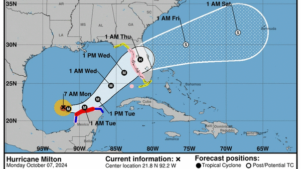
The most recent track takes Milton’s powerful eye into the mouth of Tampa Bay, threatening a heavily populated region that is extremely vulnerable to coastal flooding and cuts through some of the most densely populated areas of the state, including Orlando, before spitting back out on the east coast near Cape Canaveral.
The exact landfall location is hard to pinpoint this far out and will continue to wiggle back and forth as the hurricane center refines its projections. The latest projections for storm surge suggest the Tampa Bay region, including Bradenton, could see 10 to 15 feet of surge. Areas just to the south and north, including Naples, could see 6 to 10 feet.
For many communities on the Gulf Coast, that could be worse than the devastating Hurricane Helene, which brought about 7 feet of surge to the Tampa Bay area. State and local officials are racing around the clock to clear debris left on streets from Helene before it becomes projectiles in Milton’s high winds.
In a Monday morning press conference, Gov. Ron DeSantis said the efforts have made a dent in the remaining mess, but he urged residents to finish their preparations for the storm by Tuesday evening.
“Time is going to start running out very, very soon,” he said.
New, higher projections call for up to 15 feet of storm surge for Tampa Bay. NHC
Some mandatory evacuations have already been called in six Florida counties, including Pinellas and Manatee, but more are expected Tuesday ahead of Milton’s arrival. Tolls were lifted in west central Florida, central Florida and Alligator Alley and officials said the roads were already full of drivers headed east and north.
Florida Department of Emergency Management Director Kevin Guthrie said Sunday the state was preparing for “the largest evacuation we have seen since, most likely, 2017 Hurricane Irma.”
On Monday, he warned that shelters were expected to fill up, and the state was already identifying backup locations for additional shelters when the first wave gets crowded. Guthrie told residents that the amount of storm surge they were expecting in the Tampa Bay area was life-threatening.
“If they’ve called your evacuation zone, I beg you, I implore you, to evacuate,” he said. “ I would highly recommend anybody who’s got the means to do so… get on the road today, wherever that may be.”
A rapidly intensifying storm
As of 5 p.m. Eastern time, the National Hurricane Center said Milton was a category 5 hurricane packing 180 mph sustained winds.
“There is such thing as “extreme rapid intensification” and Milton has done it,” tweeted NBC Meteorologist Kathryn Prociv.
Extreme rapid intensification is defined as more than a 60 mph increase in sustained winds in 24 hours. Milton gained 90 mph, Prociv said. The storm’s sustained winds went from 60 mph at 8 a.m. Sunday to 150 mph at 9 a.m. Monday.
It could keep strengthening. The most recent forecast calls for Milton to top out at 185 mph sustained winds before getting smacked with strong wind shear on Wednesday.
That could bring Milton back down to a Category 3 with 125 mph winds ahead of landfall, a move that may provide slightly weaker winds but could also grow the size of the storm’s wind field considerably, which could spread its damaging effects over a broader area.
Milton is also expected to speed across Florida fast enough to hold onto its hurricane status — likely as a category 1 — as it moves inland. That could bring heavy, flooding rains and the potential for tree-felling winds far inland to areas as north as Orlando and all the way down to South Florida.
For South Florida, the weather will start to degrade on Wednesday, with the worst of the sustained winds and gusts overnight. The latest forecast predicts sustained winds around 40 mph with higher gusts, as well as several inches of rain on top of the current blast already flooding streets in coastal Miami-Dade and Broward.
©2024 Miami Herald. Visit at miamiherald.com. Distributed by Tribune Content Agency, LLC.


Comments