Milton, packing 155 mph winds, soon to hit Cat 5. Much of Florida Gulf Coast on alert
Published in News & Features
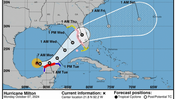
MIAMI — Hurricane Milton rapidly strengthened into a major Category 4 hurricane Monday morning, days ahead of its expected landfall on Florida’s west coast as a Category 3, where it could bring up to 12 feet of storm surge despite the lower category.
Most of Florida’s Gulf Coast is under a hurricane or tropical storm watch, although the latest forecast nudges the landfall location back up north, into the mouth of Tampa Bay.
The exact landfall location is hard to pinpoint this far out and will continue to wiggle back and forth as the National Hurricane Center refines its projections. The latest projections for storm surge suggest the vulnerable Tampa Bay region, including Bradenton, could see 8 to 12 feet of surge. Areas just to the south and north, including Naples, could see 5 to 10 feet.
For many communities on the Gulf Coast, that could be worse than the devastating Hurricane Helene, which struck just under two weeks ago and brought about 7 feet of surge to the Tampa Bay area. State and local officials are racing around the clock to clear debris left on streets from Helene before it becomes projectiles in Milton’s high winds.
In a Monday morning press conference, Gov. Ron DeSantis said the efforts have made a dent in the remaining mess, but he urged residents to finish their preparations for the storm by Tuesday evening.
“Time is going to start running out very, very soon,” he said.
Some mandatory evacuations have already been called in Manatee, Pasco and Pinellas Counties, but more are expected Monday and Tuesday ahead of Milton’s arrival. Tolls will be lifted in west central Florida, central Florida and Alligator Alley.
Florida Department of Emergency Management Director Kevin Guthrie said Sunday the state was preparing for “the largest evacuation we have seen since, most likely, 2017 Hurricane Irma.”
On Monday, he warned that shelters were expected to fill up, and the state was already identifying backup locations for additional shelters when the first wave gets crowded. Guthrie told residents that the amount of storm surge they were expecting in the Tampa Bay area was life-threatening.
“If they’ve called your evacuation zone, I beg you, I implore you, to evacuate,” he said. “I would highly recommend anybody who’s got the means to do so… get on the road today, wherever that may be.”
A rapidly intensifying storm
As of 11 a.m., the National Hurricane Center said Milton was already a category 4 hurricane packing 155 mph sustained winds, on the cusp of Category 5.
“There is such thing as “extreme rapid intensification” and Milton has done it,” tweeted NBC Meteorologist Kathryn Prociv.
Extreme rapid intensification is defined as more than a 60 mph increase in sustained winds in 24 hours. Milton gained 90 mph, Prociv said. The storm’s sustained winds went from 60 mph at 8 a.m. Sunday to 150 mph at 9 a.m. Monday.
The latest forecast calls for continued strengthening in the super-warm waters of the Gulf of Mexico to a Category 5 with 165 mph maximum winds.
It also calls for Milton to come back down to a Category 3 with 125 mph winds ahead of landfall, a move that may provide slightly weaker winds but could also grow the size of the storm’s wind field considerably, which could spread its damaging effects over a broader area.
Milton is also expected to speed across Florida fast enough to hold onto its hurricane status — likely as a category 1 — as it moves inland. That could bring heavy, flooding rains and the potential for tree-felling winds far inland to areas as north as Orlando and all the way down to South Florida.
For South Florida, the weather will start to degrade on Wednesday, with the worst of the sustained winds and gusts overnight. The latest forecast predicts sustained winds around 40 mph with higher gusts, as well as several inches of rain on top of the current blast already flooding streets in coastal Miami-Dade and Broward.
When and where the eye comes ashore matters for understanding which areas suffer the highest winds and surge, but experts said Milton will likely be a threat to places far from the eye.
“The track guidance is in good agreement that the hurricane will cross the Florida Peninsula, but there remains significant differences in both the location and timing of landfall,” NHC Forecaster Jack Bevan wrote in the 5 a.m. update.
©2024 Miami Herald. Visit at miamiherald.com. Distributed by Tribune Content Agency, LLC.


Comments