Hurricane Milton intensifies to major Category 3 storm, prompts Florida storm surge warnings, hurricane watches
Published in News & Features
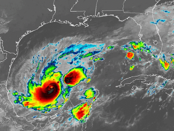
ORLANDO, Fla. — Hurricane Milton continued to strengthen early Monday hitting 125 mph sustained winds making it a major Category 3 storm on its way to an expected landfall on Florida’s Gulf Coast.
“Further strengthening is expected, and Milton is forecast to become an extremely dangerous Category 4 hurricane later today and maintain that intensity for the next couple of days,” said NHC senior hurricane specialist Eric Blake.
The NHC’s 8 a.m. update had Hurricane Milton with 125 mph sustained winds. It was located about 745 miles west-southwest of Tampa, moving east-southeast at 8 mph. Hurricane-force winds extend out 35 miles and tropical-storm-force winds extend out 80 miles.
“An eastward to east-southeastward motion is forecast through tonight, followed by a turn toward the east and northeast on Tuesday and Wednesday,” Blake said. “On the forecast track, Milton is forecast to move near or just north of the Yucatan peninsula today and Tuesday, then cross the eastern Gulf of Mexico and approach the west coast of the Florida peninsula by Wednesday.”
The system had only 50 mph sustained winds as of 5 a.m. Sunday, marking a rapid intensification of 75 mph in just 27 hours.
The NHC’s intensity forecast updated as of 5 a.m. Monday has growing to a peak intensity as a Category 4 major hurricane with 145 mph sustained winds and 175 mph gusts, but it could reduce strength as it approaches Florida’s coast on Wednesday. The next intensity update is at 11 a.m.
“The system is still likely to be a large and powerful hurricane at landfall in Florida, with life-threatening hazards along portions of the the coastline,” NHC senior hurricane specialist Jack Beven said.
A hurricane watch in Florida has been issued from Chokoloskee to the mouth of the Suwannee River including Tampa Bay and the Dry Tortugas while a storm surge watch is in effect for the Gulf Coast from Flamingo north to the Suwannee River, Charlotte Harbor and Tampa Bay.
A tropical storm watch is in effect for the Florida Gulf Coast from Flamingo to south of Chokoloskee and north of the Suwannee River to Indian Pass, and in the lower, middle and upper Florida Keys including Florida Bay.
In Mexico, a hurricane warning is in effect for the coast of the Yucatan peninsula from Celestun to Rio Lagartos, a hurricane watch from Rio Lagartos to Cabo Catoche and from Campeche to south of Celestun, and tropical storm warning from Rio Lagartos to Cancun and from Campeche to south of Celestun.
The NHC began projecting storm surge along the Gulf Coast as high as 12 feet from the Anclote River north of Tampa south to Englewood including Tampa Bay, and as high as 10 feet from the Anclote River north to Yankeetown and from south of Englewood to Bonita Beach including Charlotte Harbor, as high as 7 feet from Bonita Beach south to Chokoloskee and as high as 5 feet from Yankeetown north to the Suwannee River.
“While it is too soon to specify the exact magnitude and location of the greatest impacts, there is an increasing risk of life-threatening storm surge and damaging winds for portions of the west coast of the Florida Peninsula beginning early Wednesday and storm surge and hurricane watches will likely be issued tonight or early Monday,” the NHC stated.
Rainfall also is forecast to dump 5-10 inches across much of the state with some areas getting as much as 15 inches.
While the intensity may fall just before landfall, the wind shear will be push stronger winds farther east.
“Vertical wind shear is forecast to markedly increase as Milton approaches Florida, and some weakening is anticipated,” Blake said. “However, the regional hurricane models are showing the system growing even if it weakens, and we are expecting Milton to be a large hurricane at landfall, with very dangerous impacts spread out over a big area.”
The models still have it as a Category 3 hurricane with 120 mph sustained winds and 150 mph gusts within a three-day cone that for now is targeting landfall near Sarasota but ranges south to beyond Naples and north to near Horseshoe Beach in the Big Bend.
“It should be noted that the average NHC track error at day 3 is around 100 miles, and users should not focus on the exact track,” Blake said.
The system is expected to lose intensity as it crossed the peninsula, but the projected path has it never losing hurricane strength.
The latest forecast path consensus has it moving across southern Central Florida where it would still be a Category 1 storm with 85 mph sustained winds and 90 mph gusts, then exiting over Cape Canaveral in Brevard County into the Atlantic.
Gov. Ron DeSantis has declared a state of emergency for 51 of the state’s 67 counties, up from 34 declared on Saturday.
The updated list includes Alachua, Baker, Bradford, Brevard, Broward, Charlotte, Citrus, Clay, Collier, Columbia, DeSoto, Dixie, Duval, Flagler, Gilchrist, Glades, Hamilton, Hardee, Hendry, Hernando, Highlands, Hillsborough, Indian River, Lafayette, Lake, Lee, Levy, Madison, Manatee, Marion, Martin, Miami-Dade, Monroe, Nassau, Okeechobee, Orange, Osceola, Palm Beach, Pasco, Pinellas, Polk, Putnam, Sarasota, Seminole, St. Johns, St. Lucie Sumter, Suwanee, Taylor, Union, and Volusia counties.
Mandatory evacuations are set to begin Monday for many Gulf Coast barrier islands and other low-lying areas, and several west coast counties have announced school closures for the coming week.
In Central Florida, UCF and Valencia State College canceled classes Tuesday-Thursday while Rollins canceled classes for the whole week. Osceola County announced no classes Wednesday already with other schools likely to announce closures this week later today.
SunRail announced it would shut down beginning Tuesday and remain closed through at least Thursday depending on the storm impact.
DeSantis spoke from the State Emergency Operations Center in Tallahassee on Sunday morning and evening, and is set to speak again Monday at 9:30 a.m.
“You do have time to prepare. The storm is not going to come today or tomorrow, or likely on Tuesday as well,” he said. “So we’re looking at more the middle of the week. So you have time to do what you need to do, but this could potentially be a major hurricane. No matter what happens, it is going to have impacts to the state of Florida.”
He said there is still a lot of uncertainty as to where it will come on shore, but warned of potential deadly storm surge and damaging winds, urging people to not wait until the last minute to prepare.
“Put your hurricane preparedness plan in place, make sure your gas tanks are filled. Make sure you have enough water and nonperishable food to last you as long as the power may be out, clear up loose objects in your yard. Obviously, the big debris piles, you need that to get hauled away. But anything other than that that isn’t debris,” he said.
He said to expect both voluntary and mandatory evacuations, especially on the barrier islands, which just saw deadly storm surge because of Hurricane Helene.
“An eastward to east-northeastward motion is forecast on Monday, followed by a faster northeastward motion on Tuesday and Wednesday,” forecasters said. “On the forecast track, Milton is forecast to move just north of the Yucatan peninsula and across the southern Gulf of Mexico Monday and Tuesday and approach the west coast of the Florida peninsula by Wednesday.”
Impacts on Florida will include storm surge and heavy rains with 5-10 inches and some areas up to 15 inches forecast for portions of the Florida peninsula and Florida Keys through Wednesday night.
“This rainfall brings the risk of flash, urban, and areal flooding, along with minor to isolated moderate river flooding,” Brown said.
Tampa Bay and the rest of the Gulf Coast of the state just endured major storm surge and wind damage from Hurricane Helene only 10 days ago.
Much of the state including all of Central Florida remains under a flood watch from Sunday though Thursday, according to the National Weather Service.
“Excessive runoff may result in flooding of rivers, creeks, streams, and other low-lying and flood-prone locations,” the NWS advisory states. “Flooding may occur in poor drainage and urban areas.”
In addition, swells generated by the system will begin to hit the southwestern Gulf of Mexico coast today, spreading to the north and east by early next week.
The National Weather Service in Melbourne says tropical-storm-force winds could arrive Wednesday morning for Central Florida with the center of the storm hitting the coast late Wednesday afternoon or early Wednesday evening, making its way across the I-4 corridor and emerging off the east coast before daybreak Thursday.
“Deteriorating weather conditions are forecast in the form of heavy rainfall and increasing gusty winds, especially rainbands,” said NWS meteorologist Tim Sedlock. “A few tornadoes will also be in play on Wednesday.”
Rainfall across Central Florida from Sunday through Thursday would range from 4-8 inches with some areas getting up to 10 inches near the I-4 corridor north as well as north-central Brevard County, while 3-6 inches would fall farther south across Osceola and Okeechobee counties and the Treasure Coast.
“The time is now to enact your local hurricane plan and ensure you have supplies, and everything else necessary to ride out this storm,” Sedlock said.
The Space Force’s Space Launch Delta 45 late Saturday put Cape Canaveral Space Force Station and Patrick Space Force Base under HURCON 4 predicting surface winds in excess of 58 mph within 72 hours.
The NHC also is keeping track of two hurricanes in the Atlantic.
As of 5 a.m. Monday Hurricane Kirk was located about 765 miles west-northwest of the Azores moving northeast at 30 mph with sustained winds of 75 mph.
That keeps Kirk a Category 1 hurricane, with the NHC noting it has almost turned extratropical. It has lost steam since it reached Category 4 level earlier this week and becoming the season’s third major hurricane.
“An even faster east-northeastward motion is expected during the next couple of days,” forecasters said. “Although gradual weakening is expected, Kirk is forecast to become a large and strong extratropical low during the next couple of days.”
Hurricane-force winds extend out up to 90 miles and tropical-storm-force winds extend out up to 310 miles from its center with it approaching Europe by Wednesday.
Despite its distance across the Atlantic, swells from Kirk continue to hit the east coast of Florida and elsewhere this weekend bringing life-threatening surf and rip current conditions.
As of 5 a.m. Monday, Hurricane Leslie was located about 1,065 miles west of the southernmost Cape Verde Islands moving northwest at 13 mph with maximum sustained winds of 90 mph, which makes it a Category 1 hurricane.
“This general motion is expected to continue over the next few days followed by a turn toward the north-northwest on Friday,” forecasters said. “Gradual weakening is forecast to commence soon and continue through the week.”
Hurricane-force winds extend out up to 15 miles and tropical-storm-force winds extend out up to 115 miles from its center.
The NHC also has its eyes on a tropical wave expected to move off the west coast of Africa in the next few days.
“Thereafter, environmental conditions appear only marginally favorable for some development of this system while it moves westward or west-northwestward across the eastern tropical Atlantic,” forecasters said. “The system is expected to move near or over the Cape VerdeIslands on Wednesday and Thursday, and interests there should monitor its progress.”
The NHC gives it a 30% chance to develop in the next seven days.
The 2024 Atlantic hurricane season has had 13 named storms including nine hurricanes, three of which grew to major hurricane strength and four tropical storms.
Hurricane season runs from June 1-Nov. 30.
______
©2024 Orlando Sentinel. Visit at orlandosentinel.com. Distributed by Tribune Content Agency, LLC.


Comments