Rafael becomes major hurricane ahead of Cuba landfall on way to Gulf of Mexico
Published in Weather News
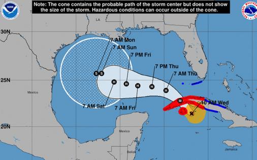
ORLANDO, Fla. — The National Hurricane Center said Hurricane Rafael grew into a major Category 3 storm Wednesday ahead of landfall in Cuba as it headed toward the Gulf of Mexico, while the Florida Keys remained under a tropical storm warning.
As of 4 p.m. Rafael, which first gained hurricane status at 7:20 p.m. Tuesday, remained a major hurricane with 115 mph sustained winds. It was located about 45 miles south-southwest of Havana, Cuba and 70 miles north of the Isle of Youth moving northwest at 13 mph.
Hurricane-force winds extend out 30 miles and tropical-storm-force winds extend out 115 miles from its center.
A hurricane warning remains in effect for the Cuban provinces of Pinar del Rio, Artemisa, La Habana, Mayabeque, Matanzas and the Isle of Youth.
A tropical storm warning is in effect for Florida’s Lower and Middle Florida Keys from Key West to west of the Channel 5 Bridge and the Dry Tortugas as well as the Cuban provinces of Villa Clara and Cienfuegos.
Rafael was expected to make landfall in western Cuba on Wednesday evening and move into the southeastern Gulf of Mexico on Wednesday night.
“Little change in strength is expected before Rafael makes landfall in western Cuba,” forecasters said. “Some weakening is forecast while Rafael crosses western Cuba, but the storm is forecast to remain a hurricane over the southeastern Gulf of Mexico.”
Effects began hitting southwest Florida on Wednesday with the National Weather Service in Miami forecasting 1-3 inches of rain, especially in the middle and lower Keys.
“There is a limited tornado threat, with the primary area of concern being over interior and southwest portions of the region,” NWS forecasters said.
Deep moisture buildup from ahead of the storm will push into Central Florida by Wednesday evening.
Marine hazards remain the primary concern for the Gulf Coast.
Storm surge is projected to range from 1-3 feet in the Dry Tortugas and 1-2 feet in the lower Florida Keys.
Immediate concerns for the Caribbean included rainfall totals could reach more than 12 inches over Cuba through midweek with the threat of flash flooding and mudslides.
Once it makes it into the Gulf of Mexico, its final destination along the Gulf Coast remains uncertain. The five-day forecast track has a wide range of potential that includes Louisiana and Texas, but it also could turn back south toward Mexico.
“It is too soon to determine what, if any, impacts Rafael could bring to portions of the northern Gulf Coast. Residents in this area should regularly monitor updates to the forecast,” forecasters said.
Its intensity, though, should drop from hurricane strength before landfall with drier air and stronger vertical wind shear present in the central Gulf of Mexico.
The NHC also continued to track a trough of low pressure that is producing disorganized showers and thunderstorms to the east-northeast of the Caribbean’s Leeward Islands.
“This system is expected to move generally westward during the next few days, and an area of low pressure could form near the northern Leeward Islands tonight or Thursday,” forecasters said. “Afterward, some gradual development of this system is possible toward the end of the week and into the early part of the weekend while it moves near or to the north of the Virgin Islands and Puerto Rico, and approaches the Southeast Bahamas.”
The NHC gave it a 20% chance to develop in the next two days and 30% in the next seven days.
The 2024 Atlantic hurricane season has produced 17 named storms, with 11 of the systems having grown into hurricanes, three of which have struck Florida’s Gulf Coast.
Five of the 11 hurricanes have grown into major hurricanes of Category 3 strength or stronger.
The official hurricane season runs through Nov. 30.
____
©2024 Orlando Sentinel. Visit at orlandosentinel.com. Distributed by Tribune Content Agency, LLC.


Comments