Hurricane Milton makes Florida landfall as a Category 3 storm; multiple tornado deaths reported
Published in Weather News


ORLANDO, Fla. — Hurricane Milton made landfall on Siesta Key on the Florida Gulf Coast on Wednesday night as a major Category 3 hurricane with 120 mph winds as the state has endured an assault of at least 19 tornadoes that resulted in multiple deaths.
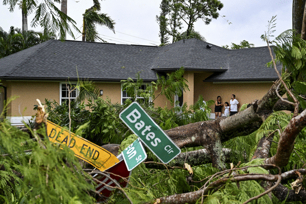
St. Lucie County Sheriff Keith Pearson said the county had more than a dozen confirmed tornado touchdowns, and one destroyed a senior community neighborhood made up of mostly mobile homes.
“They didn’t stand a chance,” he said, but did not give details about how many had died.
The National Hurricane Center said the eye of the hurricane passed over the barrier island just west of Sarasota at 8:30 p.m.
“The northern eyewall of Hurricane Milton is beginning to move onshore of the Florida gulf coast near Tampa and St. Petersburg where an Extreme Wind Warning is now in effect,” the National Hurricane Center warned at 7 p.m. “Please shelter in place as these extremely dangerous hurricane-force winds overspread the region.”
As of the special 8:30 p.m. advisory, the center of Milton was located about 5 miles west of Sarasota and 115 miles southwest of Orlando moving east-northeast at 15 mph with maximum sustained winds of 120 mph, making it a major Category 3 hurricane having dropped from Category 5 hurricane it had been overnight.
By 11 p.m., the storm was located 75 miles southwest of Orlando and 100 miles west-southwest of Cape Canaveral moving east-northeast at 16 mph with maximum sustained winds of 105 mph, which is still a Category 2 hurricane.
The updated path has the system headed northeast, but south of Lakeland and Orlando headed for northern Brevard County with a likely exit into the Atlantic near Cape Canaveral.
The NHC reported that as of 10 p.m., a sustained wind of 69 mph and a gust of 102 mph was recently reported at the Sarasota-Bradenton International Airport. A sustained wind of 86 mph and a gust of 105 mph was recently reported at a WeatherFlow station at Egmont Channel. A sustained wind of 74 mph and a gust of 98 mph was recently reported at a NOS station at Middle Tampa Bay. A gust of 91 mph was recently reported at a Citizen Weather Observer Program station in Bartow.
A Flash Flood Emergency is in effect for the Tampa Bay area, including the cities of Tampa, St. Petersburg, and Clearwater until 2:30 a.m.. Albert Whitted Airport in St. Petersburg has received 16.61 inches of rain so far today.
A flash flood warning continues for Brandon, Lakeland and Palm Harbor until 1 a.m., and for Central Florida until 11:45 p.m.
The NHC said life-threatening storm surge, extreme winds and flash flooding continue and it moves inland.
“The storm is here. It’s time for everybody to hunker down,” said Gov. Ron DeSantis at an evening news conference. “If you start to get in a situation where trees are snapping, power’s popping, you do have to treat it like a tornado. And then, if you are in a tornado warning that’s a duck and cover in a place that’s safe in your structure. Those can be very, very dangerous, even if you are inside.”
He said the storm picked up speed making landfall earlier than forecast, but that meant it was coming in ahead of high tide, which should help with the storm surge threat, which was forecast to be between 5-13 feet from the Charlotte-Lee county line up to Anna Maria Island.
Hurricane-force winds extend out 35 miles and tropical-storm-force winds extend out 255 miles from its center.
The NHC said life-threatening storm surge, extreme winds and flash flooding continue and it moves inland.
“Life-threatening hurricane-force winds, especially in gusts, are expected to spread inland across the peninsula and to portions of the Florida east coast within the Hurricane Warning area tonight and early Thursday,” forecasters said. “Residents should be prepared to take shelter in an interior room, away from windows, as the core of the hurricane moves across the central Florida Peninsula.”
The updated path brings it back further north with landfall north of Sarasota and south of Tampa Bay then heading more northeast toward Lakeland before shifting more east and heading south of Orlando toward central Brevard County.
A tornado watch had been issued for parts of Florida until 9 p.m. including Brevard, Lake, Orange, Osceola, Polk, Seminole and Volusia counties in Central Florida. The watch area could expand during the day.
Between 4 a.m. and 7 p.m., the NWS issued nearly 120 tornado warnings with more expected. DeSantis said 19 had confirmed touchdowns.
“Numerous counties have reported tornado damage,” DeSantis said.
He said there were reports of injuries, but no fatalities yet, but WPTV reported that the St. Lucie County sheriff confirmed there were “multiple fatalities” in the county.
“Sheriff Keith Pearson confirmed multiple people were killed at Spanish Lakes Country Club,” WPTV reported on their website. “It’s unclear how many people have died.”
“We’ve already seen probably more tornado watches than I’ve ever seen,” he said. “I was talking to people. ‘Do you ever remember?’ No one remembers ever seeing this many tornado warnings … there was Fort Myers, but there was Palm Beach, there was there was Port St Lucie. I mean, it was all over the state. So, so that is a hazard for sure, and I think we’re likely to continue to see those throughout tonight.”
Images captured by Florida Department of Transportation cameras on Interstate 75 showed a funnel cloud crossing in the Everglades around 10 a.m.
Lee County Sheriff Carmine Marceno posted damage from a suspected tornado in Matlacha on the Gulf Coast with power lines leaning to one side.
A large funnel cloud was captured in Wellington taking out power transformers crossing a major road.
Videos from FDOT cameras captured a massive tornado moving across Interstate 95 in St. Lucie County near Fort Pierce.
It could be the same tornado was responsible for an accident near Florida’s Turnpike after 5 p.m., and a semi-truck overturned blocking the entire highway, according to FL511.com.
Video also showed severe damage to the St. Lucie County Sheriff’s Office.
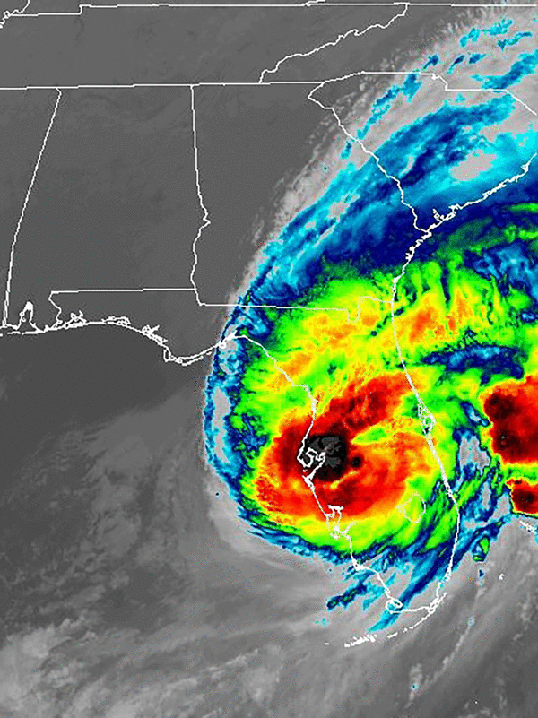
“Radar images from Tampa and Key West show that Milton is a sheared hurricane, with the heaviest precipitation to the north of the center, and the eye open on the south side,” forecasters said. “This structure was confirmed by a recent Air Force Reserve Hurricane Hunter mission, where the eyewall was reported open to the southwest.”
The forecast track’s cone of uncertainty ranges from Venice to the south and Clearwater to the north, with a potential center moving near Bradenton and inland by 8 or 9 p.m. perhaps still with the 120 mph sustained winds and 150 mph gusts it has 60 miles from shore.
It’s then forecast to keep its northeast path across the state going across central Polk near Lakeland by 2 a.m. as a Category 1 hurricane with 90 mph sustained winds and 115 mph gusts, then shift to the east-northeast across northern Osceola County near Poinciana south of Kissimmee and Orlando exiting into the Atlantic still as a Category 1 hurricane near Cape Canaveral still as a hurricane.
“Milton’s wind field is expected to grow considerably in size while it moves across Florida,” forecasters said. “Additionally, a large region of tropical storm and hurricane-force winds could occur on the northwest/back side of the storm since Milton will be interacting with a frontal boundary and beginning extratropical transition.”
Conditions in South Florida have already begun to deteriorate as an area of heavy rain ahead of the hurricane is beginning to spread across the peninsula. Power outages had begun as well, with nearly 780,000 customers without power in the state as of 9 p.m., according to poweroutage.us.
“Several tornadoes are likely today and tonight across parts of central and southern Florida,” forecasters said Wednesday.
The Florida Highway Patrol has already shut down the Sunshine Skyway Bridge, Howard Frankland Bridge and Courtney Campbell Causeway in Tampa Bay, as well as westbound traffic on the Gandy Bridge.
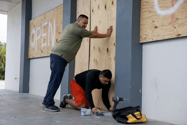
Millions were ordered to evacuate, and the state’s highways have been clogged and residents faced stations without fuel. Mandatory evacuation orders for barrier islands, mobile homes and low-lying areas were issued across 11 counties with a combined population of 5.9 million people, according to the U.S. Census Bureau.
Evacuation efforts have congested highways to the point the state has dropped all tolls in west and Central Florida and Alligator Alley. It has also opened up the shoulders on sections of Interstate 4 and 75, cleared by the state Department of Transportation, to assist in the evacuation.
The hurricane surged Monday into a Category 5 storm with 180 mph winds in the Gulf of Mexico, then lost some steam overnight as it moved over the waters just north of Mexico’s Yucatan peninsula, falling to 145 mph winds earlier Tuesday. But then it climbed back hitting 165 mph winds in the evening again.
“I know some of our residents that just experienced hurricane damage from Helene (last week) are also fatigued,” said Gov. Ron DeSantis during a Tuesday briefing. “Just hang in there and do the right thing. Just let’s get through this. We can do it together, and then on the other side of it, make sure everybody’s safe and and we’ll put the pieces back together.”
He spoke again from the State Emergency Operations Center in Tallahassee on Wednesday morning.
“We are bracing and are prepared to receive a major hit. Facing this with the seriousness it deserves, but also with the determination that we will get through this,” he said.
He said there is still time to evacuate, but the decision needs to come soon. For those who remained in an evacuation zone, his warning was dire.
“In places like Sarasota or Charlotte, just know that if you get 10 feet of storm surge, you can’t just hunker down with that. You know that is ultimately the surge, Mother Nature is going to win that fight,” he said.
He said 20 other states are assisting Florida ahead of the storm.
“This is just what we as Americans do. We’ve had opportunities to help other states in the past, including most recently in western North Carolina. And I think it shows the spirit that these states are stepping up and providing really valued support,” he said.
Some 51 counties remain under a state of emergency.
There has been a run on fuel as millions evacuated from the West Coast, but the state has on hand still 1.6 million gallons of diesel and 1.1 million gallons of gasoline.
FHP has helped 106 long-distance fuel tanker escorts delivering nearly 1 million gallons of gasoline from ports in Tampa, Jacksonville, Everglades and Manatee to help.
The Florida Department of Transportation is set for post-storm work staging 156 bridge inspectors, 328 cut-and-toss personnel and more than 1,500 pieces of heavy equipment.
Personnel from the Florida National Guard, Florida State Guard, Florida Fish and Wildlife and the Florida Highway Patrol are activated as well.
The National Guard is deploying 6,000 Guardsmen from Florida and 3,000 from other states. Other states have supplied 34 search and rescue air vehicles. The state has on hand 500 tactical vehicles, including 180 high-water vehicles, aerial, water and ground National Guard search and rescue teams.
“This is the largest Florida National Guard search and rescue mobilization in the entire history of the state of Florida,” DeSantis said.
More than 50,000 electrical linemen are being brought in from states as far as California.
“As soon as that storm passes, you’re going to see the assessments and the power restoration efforts commence immediately,” he said.
More than 500 law enforcement officers from out of state are on hand to help.
A strike near Tampa Bay could bring devastating storm surge, something the area endured already with Hurricane Helene less than two weeks ago with deadly results.
The area has not been directly hit by a major hurricane since 1921.
Inland hurricane warnings are in place for parts of the southern Florida peninsula including Central Florida’s Brevard, Lake, Marion, Orange, Osceola, Polk, Seminole, Sumter and Volusia counties.
The state has assisted in the evacuation of 202 health care facilities, he said.
Colorado State University meteorologist Phil Klotzbach said this is the latest in the calendar year ever for a Category 5 hurricane with at least 175 mph winds on record. He said it was the strongest in the Gulf of Mexico since 2005’s Hurricane Rita.
It’s also only the second October Category 5 hurricane in the satellite era since 1966 he said after 2018’s Hurricane Michael.
The Federal Emergency Management Agency announced President Biden had authorized FEMA to coordinate all disaster relief efforts in the state and approved 75% federal funding for emergency protective measures including direct federal assistance to 37 counties that were part of DeSantis’ original emergency declaration request, and the same level limited to direct federal assistance to an additional 14 counties. On Tuesday, Biden expanded the emergency declaration to the Seminole Tribe of Florida.
“The president has approved what we asked for. We’re thankful for that,” DeSantis said Monday afternoon. “If there’s something we need that they don’t approve, I will not hesitate to call him. We want to use whatever resources are available to be able to help Floridians prepare and respond to this storm. But everything we’ve asked for from President Biden, he has approved, and we do think we’ll get more approvals for some of the individual assistance and the debris removal after landfall.”
Rain forecasts have now increased with the NHC predicting some areas getting as much as 15 inches on its path.
Sedlock said 6-12 inches can be expected near north of Orlando down to Melbourne with 3-6 inches farther south.
“Rain intensity will quickly diminish Thursday night as Milton moves off of the east Florida coast and departs the area,” Sedlock said.
A flood warning is already in effect for the St. Johns River near Astor affecting Volusia and Lake counties.
The NHC also is keeping track of Hurricane Leslie in the Atlantic, that grew back to hurricane strength late Tuesday.
As of 11 a.m. Wednesday, Leslie was located about 985 miles east-northeast of the northern Leeward Islands moving northwest at 10 mph with maximum sustained winds of near 85 mph keeping it as a Category 1 hurricane after having diminished to a tropical storm most of Tuesday.
The NHC is also keeping track of two more systems with a chance to develop into the season’s next tropical depression or storm.
One is a nontropical low pressure system with gale-force winds northeast of the northwestern Bahamas and about 375 miles west-southwest of Bermuda that has become less organized as of the NHC’s 2 p.m. Wednesday tropical outlook.
“Although environmental conditions are becoming less favorable for development, a short-lived tropical or subtropical storm could still form today or this evening while the low moves northeastward to east-northeastward at around 15 mph,” forecasters said. “Upper-level winds are forecast to become too strong for further development later tonight.”
The NHC gives it a 30% chance of development in the next two to seven days.
The second system is a tropical wave forecast to move off the west coast of Africa into the far eastern Atlantic by early Thursday.
“Afterward, environmental conditions appear only marginally favorable for some limited development of this system while it moves westward or west-northwestward across the eastern tropical Atlantic and through the Cape Verde Islands late Thursday into Friday,” forecasters said.
The NHC gives it a 10% chance of development in the next two to seven days.
The 2024 Atlantic hurricane season has had 13 named storms including nine hurricanes, four of which grew to major hurricane strength, and four tropical storms.
Hurricane season runs from June 1-Nov. 30.
_______
©2024 Orlando Sentinel. Visit at orlandosentinel.com. Distributed by Tribune Content Agency, LLC.


Comments