Now a Category 3, Hurricane Milton spawns more than 100 tornado warnings ahead of landfall tonight
Published in Weather News

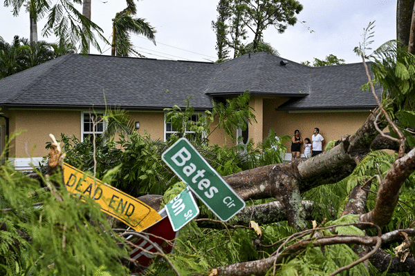


ORLANDO, Fla. — A series of tornadoes have spun up across the state ahead of Hurricane Milton’s forecast landfall on Florida’s Gulf Coast possibly before midnight as a major hurricane, according to the National Hurricane Center.
“Damaging winds, life-threatening storm surge, and heavy rainfall will extend well outside the forecast cone,” forecasters said. “This is a very serious situation, and residents in Florida should closely follow orders from their local emergency management officials.”
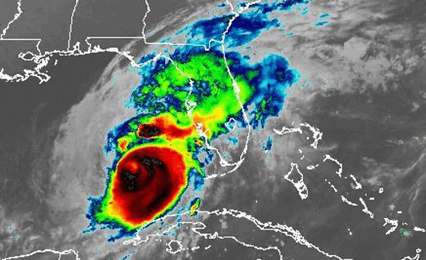
As of the NHC’s 4 p.m. EDT hourly advisory, the center of Milton was located about 100 miles west-northwest of Fort Myers and 100 miles southwest of Tampa moving northeast at 17 mph with maximum sustained winds of 125 mph, making it a Category 3 hurricane, down from Category 5 overnight.
“Now is the time to rush to complete all preparations to protect life and property in accordance with your emergency plan,” the NHC stated. “Ensure you are in a safe location before the onset of strong winds or possible flooding. Ensure you have multiple ways to receive weather warnings.”
A tornado watch has been issued for parts of Florida until 9 p.m. including Brevard, Lake, Orange, Osceola, Polk, Seminole and Volusia counties in Central Florida. The watch area could expand during the day.
Between 4 a.m. and 4 p.m., the NWS has issued more than 100 tornado warnings with more expected.
The storm’s center is compact for now with hurricane-force winds extending out 35 miles, but tropical-storm force winds have been expanding since Tuesday now out to 250 miles from its center.
An NOAA saildrone located about 50 miles east of the center as of 2 p.m. had reported a sustained wind of 52 mph and a wind gust of 70 mph.
The forecast track’s cone of uncertainty ranges from Port Charlotte to the south and St. Petersburg to the north, with a potential center moving south of Sarasota moving inland by 2 a.m. Thursday with 125 mph sustained winds and 155 mph gusts.
It’s then forecast to shift to an east-northeast path across the state going across southern Polk, Osceola and Brevard counties exiting into the Atlantic still as a Category 1 hurricane near Melbourne with 85 mph sustained winds and 105 mph gusts.
The Florida Highway Patrol has already shut down the Sunshine Skyway Bridge, Howard Frankland Bridge and Courtney Campbell Causeway in Tampa Bay, as well as westbound traffic on the Gandy Bridge.
Millions were ordered to evacuate, and the state’s highways have been clogged and residents faced stations without fuel. Mandatory evacuation orders for barrier islands, mobile homes and low-lying areas were issued across 11 counties with a combined population of 5.9 million people, according to the U.S. Census Bureau.
The hurricane surged Monday into a Category 5 storm with 180 mph winds in the Gulf of Mexico, then lost some steam overnight as it moved over the waters just north of Mexico’s Yucatan peninsula, falling to 145 mph winds earlier Tuesday. But then it climbed back hitting 165 mph winds in the evening again.
“I know some of our residents that just experienced hurricane damage from Helene (last week) are also fatigued,” said Gov. Ron DeSantis during a Tuesday briefing. “Just hang in there and do the right thing. Just let’s get through this. We can do it together, and then on the other side of it, make sure everybody’s safe and and we’ll put the pieces back together.”
He spoke again from the State Emergency Operations Center in Tallahassee on Wednesday morning.
“We are bracing and are prepared to receive a major hit. Facing this with the seriousness it deserves, but also with the determination that we will get through this,” he said.
He said there is still time to evacuate, but the decision needs to come soon. For those who remained in an evacuation zone, his warning was dire.
“In places like Sarasota or Charlotte, just know that if you get 10 feet of storm surge, you can’t just hunker down with that. You know that is ultimately the surge, Mother Nature is going to win that fight,” he said.
He said 20 other states are assisting Florida ahead of the storm.
“This is just what we as Americans do. We’ve had opportunities to help other states in the past, including most recently in western North Carolina. And I think it shows the spirit that these states are stepping up and providing really valued support,” he said.
Some 51 counties remain under a state of emergency.
There has been a run on fuel as millions evacuated from the West Coast, but the state has on hand still 1.6 million gallons of diesel and 1.1 million gallons of gasoline.
FHP has helped 106 long-distance fuel tanker escorts delivering nearly 1 million gallons of gasoline from ports in Tampa, Jacksonville, Everglades and Manatee to help.
The Florida Department of Transportation is set for post-storm work staging 156 bridge inspectors, 328 cut-and-toss personnel and more than 1,500 pieces of heavy equipment.
Personnel from the Florida National Guard, Florida State Guard, Florida Fish and Wildlife and the Florida Highway Patrol are activated as well.
The National Guard is deploying 6,000 Guardsmen from Florida and 3,000 from other states. Other states have supplied 34 search and rescue air vehicles. The state has on hand 500 tactical vehicles, including 180 high-water vehicles, aerial, water and ground National Guard search and rescue teams.
“This is the largest Florida National Guard search and rescue mobilization in the entire history of the state of Florida,” DeSantis said.
More than 50,000 electrical linemen are being brought in from states as far as California.
“As soon as that storm passes, you’re going to see the assessments and the power restoration efforts commence immediately,” he said.
More than 500 law enforcement officers from out of state are on hand to help.
A strike near Tampa Bay could bring devastating storm surge, something the area endured already with Hurricane Helene less than two weeks ago with deadly results.
The area has not been directly hit by a major hurricane since 1921.
Inland hurricane warnings are in place for parts of the southern Florida peninsula including Central Florida’s Brevard, Lake, Marion, Orange, Osceola, Polk, Seminole, Sumter and Volusia counties.
The state has assisted in the evacuation of 202 health care facilities, he said.
Colorado State University meteorologist Phil Klotzbach said this is the latest in the calendar year ever for a Category 5 hurricane with at least 175 mph winds on record. He said it was the strongest in the Gulf of Mexico since 2005’s Hurricane Rita.
It’s also only the second October Category 5 hurricane in the satellite era since 1966 he said after 2018’s Hurricane Michael.
The Federal Emergency Management Agency announced President Biden had authorized FEMA to coordinate all disaster relief efforts in the state and approved 75% federal funding for emergency protective measures including direct federal assistance to 37 counties that were part of DeSantis’ original emergency declaration request, and the same level limited to direct federal assistance to an additional 14 counties. On Tuesday, Biden expanded the emergency declaration to the Seminole Tribe of Florida.
“The president has approved what we asked for. We’re thankful for that,” DeSantis said Monday afternoon. “If there’s something we need that they don’t approve, I will not hesitate to call him. We want to use whatever resources are available to be able to help Floridians prepare and respond to this storm. But everything we’ve asked for from President Biden, he has approved, and we do think we’ll get more approvals for some of the individual assistance and the debris removal after landfall.”
Rain forecasts have now increased with the NHC predicting some areas getting as much as 15 inches on its path.
Sedlock said 6-12 inches can be expected near north of Orlando down to Melbourne with 3-6 inches farther south.
“Rain intensity will quickly diminish Thursday night as Milton moves off of the east Florida coast and departs the area,” Sedlock said. “With
A flood warning is already in effect for the St. Johns River near Astor affecting Volusia and Lake counties.
The NHC is also keeping track of two more systems with a chance to develop into the season’s next tropical depression or storm.
One is a nontropical low pressure system with gale-force winds northeast of the northwestern Bahamas and about 375 miles west-southwest of Bermuda that has become less organized as of the NHC’s 2 p.m. Wednesday tropical outlook.
“Although environmental conditions are becoming less favorable for development, a short-lived tropical or subtropical storm could still form today or this evening while the low moves northeastward to east-northeastward at around 15 mph,” forecasters said. “Upper-level winds are forecast to become too strong for further development later tonight.”
The NHC gives it a 30% chance of development in the next two to seven days.
The second system is a tropical wave forecast to move off the west coast of Africa into the far eastern Atlantic by early Thursday.
“Afterward, environmental conditions appear only marginally favorable for some limited development of this system while it moves westward or west-northwestward across the eastern tropical Atlantic and through the Cape Verde Islands late Thursday into Friday,” forecasters said.
The NHC gives it a 10% chance of development in the next two to seven days.
The 2024 Atlantic hurricane season has had 13 named storms including nine hurricanes, four of which grew to major hurricane strength, and four tropical storms.
Hurricane season runs from June 1-Nov. 30.
_______
©2024 Orlando Sentinel. Visit at orlandosentinel.com. Distributed by Tribune Content Agency, LLC.


Comments