High winds and tornadoes lash Florida as Category 3 Hurricane Milton closes in on Gulf Coast
Published in Weather News
MIAMI — Now-Category 3 Hurricane Milton clawed at Florida’s Gulf Coast on Wednesday afternoon with tropical-storm-force winds, accompanied by small scattered tornadoes as far south as Broward County, as the powerful storm pushed closer to its overnight landfall.
Bridges were closed and access to barrier islands locked off. Airports, schools and government facilities were shut down. Shelters were beginning to fill up in the danger zone as the state and counties raced to open more and direct last-minute evacuees to safety.
The storm, with sustained winds clocking in at 120 mph, finally made the fateful turn to the northeast that will steer it toward what promises to be a catastrophic strike sometime in the darkness of late Wednesday night or early Thursday — likely as a Category 3. It’s expected to bring roof-ripping winds and potentially lethal walls of water as high as 13 feet in some places.
Water levels began to rise in Tampa and near Naples, and some tornadoes tore roofs off homes in Fort Myers. On the other coast, Milton’s rains caused deep street flooding in St. John’s County.
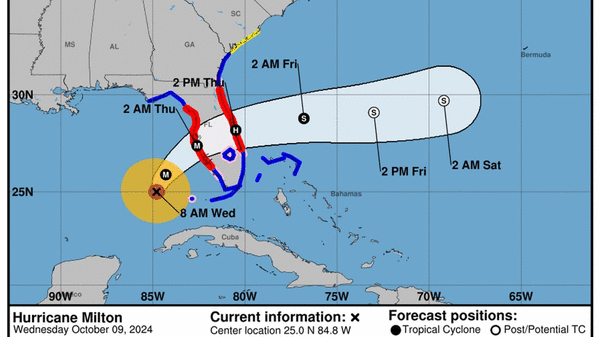
At 5 p.m. Eastern time Wednesday, the forecast track from the National Hurricane Center was slightly south of the mouth of Tampa Bay and heavily populated communities that are extremely vulnerable to storm surge. If it remains on that path, Sarasota and coastal cities to the south, including Fort Myers Beach, which is still rebuilding from Category 4 Hurricane Ian two years ago, would see the worst of the surge.
Wednesday, storm surge predictions for those areas dropped slightly to 9 to 13 feet for Sarasota and 8 to 12 feet for the Fort Myers and Naples area, while predictions for Tampa Bay dropped from a peak of 15 feet to 9 feet.
However, a wobble back north to Tampa was still possible. Forecasters have repeatedly warned that there will be widespread, potentially lethal coastal flooding along much of the coast — including in the Tampa Bay region — no matter where Milton comes in.
“We’re bracing for that, but we’re doing everything we can to mitigate the damage beforehand and we’ll do everything we can to get people back on their feet afterward,” Gov. Ron DeSantis said during a state news conference Wednesday morning.
Federal officials also said they’re in place and ready for Milton to strike. FEMA says the Biden administration has ordered 1,200 search and rescue personnel from FEMA, the Coast Guard and Defense Department to preposition in the state to immediately respond to Milton, supplementing 1,000 who are already on the ground. Millions of meal packets have already been sent to the state in advance of landfall. The emergency response agency also says that 30 high-water vehicles and helicopters, as well as 500 ambulances, have already deployed to the state.
FEMA Administrator Deanne Criswell said she plans to work side by side with DeSantis. A national team is directly embedded in the city of Tampa, “so we can have a seamless flow of communication as they are experiencing the impacts, and we can help provide the resources they need for those initial life-saving efforts,” Criswell said during a Wednesday morning news briefing.
As Milton approached the state, tornadoes sprung up across South Florida, including one that crossed directly over I-75 in western Broward Wednesday morning. More were expected. Mike Brennan, director of the National Hurricane Center, said the threat of tornadoes was greater than usual for most landfalling hurricanes, especially from Orlando to Lake Okeechobee.
“Those tornadoes and those small thunderstorms will be advancing northward out ahead of Milton’s landfall and create dangerous conditions across the Florida peninsula,” he said in a Wednesday morning briefing.
Florida Power and Light President and CEO Armando Pimentel said Wednesday afternoon that the company had over 17,000 workers from over 40 states stationed and ready to help restore power when it was safe to do so. Some had already begun restoration in Southwest Florida in between Milton’s bands, he said.
As of Wednesday afternoon, over 36,000 FPL customers had been affected, with 15,000 customer’s power restored. Lee and Manatee counties had been most impacted, according to FPL’s reported outages.
Pimentel said it was too early to estimate how many customers would lose power, but said that customers across the state should be prepared to be affected given the size of the storm, its wind speed and the vast amount of area it is forecast to batter.
“We anticipate a challenging environment restoring power,” Pimentel said, but assured FPL was prepared to respond quickly, assess damages, and restore power when possible after the storm passes.
Historically, Pimentel said, FPL has been able to provide estimated restoration times for counties across the state roughly 24 hours after the storm, and are prepared to do so again.
Floridians flee
Milton’s path and power — a picture-perfect buzzsaw blade on satellite image early Wednesday before growing more ragged later in the day — promised to leave a swath of damage across much of the central peninsula. There will certainly be widespread power outages, wiped-out coastal homes, and ripped-off roofs. The damage from coast to coast could be historic in a state with a long, expensive history of hurricane strikes. There’s some hope that the potential death toll won’t be.
Millions of Floridians fled the coast over the last few days, clogging highways and draining gas stations from Naples to Cedar Key. Many were still cleaning up from the passage of Hurricane Helene, which flooded thousands of homes. The Tampa Bay region experienced its worst coastal flooding in a century, though Helene’s core remained as much as a hundred miles offshore.
The entire Florida Gulf Coast bears recent hurricane scars. Just two years ago, Category 4 Hurricane Ian destroyed Fort Myers Beach, drowning the city. That storm wound up the deadliest in Florida in nearly a century, killing 149 people, including 72 in Lee County, many who had failed to evacuate.
More than 30,000 Floridians are now in 149 public shelters around the state, the governor said. But there’s room for 200,000. DeSantis urged people to head to shelters now if they are still able to safely do so.
However, the governor acknowledged that despite fervent calls for evacuation in flood-prone areas, some people have decided to stay. And while officials have pledged to try to rescue everyone they can when the waters start to rise, at a certain point they will be physically unable to reach people.
“Unfortunately, there will be fatalities. I don’t think there’s a way around it when you have storm surge that’s over 10 feet,” he said. “Why would you want to risk it at this point?”
Many coastal Floridians, especially those who were in the path of Hurricane Helene, aren’t willing to take that chance.
When Isabel and Javier Dubrocq saw on the news Wednesday morning that Milton was expected to make landfall as a Category 4, and forecasts kept nudging the center of storm’s track south, they made the call. They started to move furniture inside their Sarasota home, about half a mile from the Gulf.
“We’re leaving in a couple of hours,” said Isabel Dubrocq, a local dance teacher. They’re heading to her brother’s home five miles inland to ride out the storm with Javier’s 85-year-old mother and their dog Taco Bella, Taquito for short.
“Two weeks ago, Helene came and this city was floating,” said Javier, as he and his wife boarded up a window. “This street didn’t flood though.”
Still, they won’t be risking it as Milton tears through Florida.
“That last thing I’m thinking about is what this house will look like,” said Javier, an artist. “I’m thinking about our safety.”
Over his shoulder, a polystyrene slab and lime green seat cushions were jammed between a glass window and several wooden boards screwed into the frame.
He held a power drill in his right hand as Isabel hoisted an umbrella over his head. As he stepped toward another window, his T-shirt commemorating an exhibit by artist M.C. Escher came into clear view — a close-up image of an eye.
Wind shear takes a bite out of Milton
The storm was about 60 miles west-southwest of Sarasota Wednesday evening and the first gusts of tropical storm winds had begun sweeping the Gulf Coast. By 5 p.m., Milton had picked up the pace to 17 mph as it rushed toward Florida.
Under an onslaught of wind shear and dry air, Milton’s maximum winds dropped to 120 mph — the same intensity forecasters expect it will slam the Sarasota area with overnight. It’s set to maintain hurricane strength as it crosses the state Thursday, potentially over some of the most densely populated areas in the state.
Wherever Milton makes landfall, the areas nearest to the center or to the south are expected to see the highest storm surge. Areas to the north could see more rain and a higher chance of tornadoes.
But as Floridians anxiously watch every new model run or hurricane hunter update to predict where, exactly, Milton’s eye could come ashore, the hurricane center insisted that it will be tough to nail until just before landfall.
“We would like to emphasize that Milton’s exact landfall location is not possible to predict even at this time, particularly if the hurricane wobbles during the day and into this evening. Even at 12-24 hours, NHC’s track forecasts can be off by an average of 20-30 nautical miles,” forecasters warned in the 11 a.m. update.
By Wednesday afternoon, Milton’s wind field already reached 250 miles from the center. Hurricane-force winds stretched up to 35 miles from the center. The now-broader storm is expected to bring 125 mph sustained winds and higher gusts, plus record-setting storm surge, to much of Florida. Milton could also bring more than a foot of rain to areas north of its eye, up to 18 inches in some spots.
South Florida remained under a tropical storm watch, but Miami-Dade and Broward counties will likely see just squally weather, with gusts up to 45 mph. There could be some fast-moving storms but the National Weather Service lifted a flash flood warning early Wednesday. The Florida Keys could see coastal flooding from storm surge, as well as gusts up to 65 mph.
Florida is ready for Milton
Most of the state, far beyond the expected landfall area, was hunkering down for Milton’s arrival. Major airports in Tampa and Orlando prepared to shut down. Schools announced pending closures across much of the state, including in South Florida. Millions of residents across the state were under hurricane warnings or watches.
As rain fell Tuesday on Palm Bay, a Brevard County city about 4 miles west of Melbourne Beach, business owners were busy making preparations for Milton. Nobody knew what the storm would do as it traversed Florida, but forecasters expected it will still be a hurricane when it gets here.
Tattoo shop owner Dave Parker and his tattoo artist Jesse Cuen were cutting plywood and boarding up Parker’s High Class Ink Studio on Babcock Street Parker. Parker said Palm Bay has faced hurricanes before, but this is the first time he’s decided to board up his shop. He also buttoned up his studio in Rockledge, about 30 miles inland and closer to Milton’s projected path.
“I don’t want to take a chance with these guys’ livelihood or mine,” Parker said as he sawed a portion of plywood.
Across the Melbourne Causeway, at the Copperhead Tavern — a small outdoor bar and grill on Fifth Avenue and A1A — business was steady Tuesday evening with people ordering drinks, burgers, fish and chips and mahi tacos.
Manager and bartender Alexis Bragg was serving customers as other staff pulled in chairs from the patio and covered computers with plastic trash bags.
“Everybody I’ve been talking to today, no one is leaving,” Bragg said. “They’re just hunkering down.”
The 27-year-old said she’d be heading to her mother’s house in Palm Bay because she lives in a first-floor apartment near the beach that floods on a regular basis just on a normal rainy day.
“If it was on the second level, I would stay. But we lose power super easy at my apartment, and my mom has a generator,” Bragg said. “We’ll just party there. It’s fine.”
_____
(Miami Herald staff writers Milena Malaver, Ana Claudia Chacin and Ana Ceballos and McClatchy Washington bureau correspondent Michael Wilner contributed to this report.)
©2024 Miami Herald. Visit at miamiherald.com. Distributed by Tribune Content Agency, LLC.


Comments