As millions in Florida flee Hurricane Milton, climate change seen in back-to-back monster storms
Published in Weather News


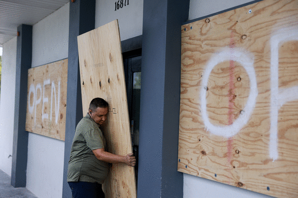


Hurricane Milton raced toward Florida’s already battered Tampa Bay region Wednesday, as forecasters warned that the once-in-a-generation storm was expected to bring life-threatening storm surge, destructive winds and flooding.
“This could be the worst storm to hit Florida in over a century,” President Biden said Wednesday. “God willing, it won’t be, but that’s what it’s looking like right now. ... My priority is to increase the size and presence of our [federal personnel] ... as we prepare for another catastrophic storm about to make landfall.”
The storm comes less than two weeks after Hurricane Helene devastated communities across the southeast, including Tampa, the first U.S. city expected to be hit by the latest Category 4 storm.
“This is going to be a serious storm, one that could forever change communities that are still recovering from Helene,” Federal Emergency Management Agency Administrator Deanne Criswell said at a briefing Wednesday. But despite facing back-to-back large-scale disasters, officials said, the federal agency is prepared for Hurricane Milton, having positioned food and water resources for millions, as well as additional personnel, including extra search and rescue teams, power assessment teams and ambulances to assist with evacuating medical facilities.
“FEMA is ready. Our agency is postured to respond to this storm and help the state of Florida,” Criswell said. “These resource movements are not taking away from the ongoing, complicated response and recovery we are still working in the aftermath of Helene.”
All the same, she didn’t minimize the immense challenge facing the agency, which is currently responding to the most federal disasters in any one year of her tenure.
“As we continue to see the impacts of climate change cause more severe weather events across the U.S., we are going to see more communities impacted, and we are going to see them continue to need assistance,” Criswell said. She said “storm after storm” has been more intense, with more water, more wind and more destruction.
“Two massive storms have come our way in only a matter of weeks, but this is what we do,” she said. “We are here to help people, we are here to save lives.”
Scientists for years have found that human-caused changes in climate, particularly warming ocean temperatures, supercharge tropical storms in the Atlantic, fueling more rain and stronger winds.
Already, a team of international scientists determined that climate change made it up to 500 times more likely that Hurricane Helene would encounter such high surface temperatures in the Gulf of Mexico, driving the storm’s rapid intensification and unprecedented moisture.
The storm’s rainfall was also about 10% heavier due to climate change, according to the new analysis from the World Weather Attribution, a group of scientists from the United States, the United Kingdom, Sweden and the Netherlands who calculate the role of climate change in extreme weather events using weather observations and computer modeling.
Hurricane Milton was briefly listed as a Category 5 storm as spiraled across the Gulf of Mexico toward Florida’s west coast, but its intensity decreased slightly Wednesday, with forecasters expecting it would drop to a Category 3 or 4 hurricane by the time it makes landfall, the National Weather Service said in its 8 a.m. update Wednesday.
It was expected to reach Florida’s Gulf Coast late Wednesday or early Thursday. Officials say the Tampa Bay region could face a direct hit, but the exact path of the storm remains unclear.
Nearly 6 million people have been told to evacuate in one of the biggest such orders in Florida history.
Florida Gov. Ron DeSantis on Wednesday urged those who had not yet left evacuation zones to find local shelters and “drive tens of miles — not hundreds of miles.”
The National Hurricane Center in Miami warned that the time to evacuate and prepare for Milton was coming to an end along the state’s west coast.
“Milton has the potential to be one of the most destructive hurricanes on record for west-central Florida,” forecasters wrote.
A top concern is massive storm surge. Points along the state’s west coast could see a surge of up to 15 feet.
The northbound lanes of Interstate 75, which runs west from Fort Lauderdale to Naples before heading north through Tampa and into Georgia, were gridlocked for much of Monday and into Tuesday morning. More than 20% of gas stations in Florida were reported to be out of fuel, including almost 60% of gas stations in Tampa and St. Petersburg, according to GasBuddy.
Hurricane Helene entered Florida’s Big Bend region late on Sept. 26 as a Category 4 storm, eventually claiming more than 230 lives as it left a trail of devastation from Florida to Tennessee.
Criswell said teams remain on the ground in North Carolina and other states most affected by Helene, noting that already $60 million in individual assistance grants had been issued.
“This is incredible, meaningful progress,” she said.
©2024 Los Angeles Times. Visit at latimes.com. Distributed by Tribune Content Agency, LLC.


Comments