Hurricane Milton: Tornado watch issued including parts of Central Florida
Published in Weather News
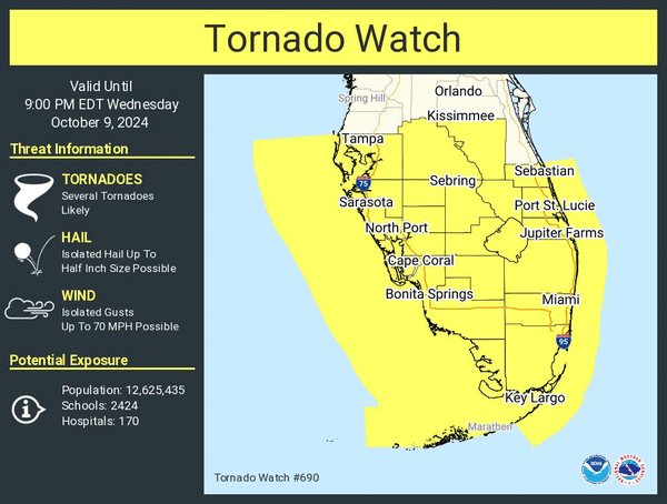
ORLANDO, Fla. — The National Weather Service has issued a tornado watch for parts of Florida as Hurricane Milton approaches the state.
The watch issued before 8:30 a.m. runs until 9 p.m. and for now includes all of the southern portion of the Florida peninsula up into Central Florida’s Polk and Osceola counties.
Images captured by Florida Department of Transportation cameras on Interstate 75 showed a funnel cloud crossing in the Everglades around 10 a.m.
More tornadoes were seen across the state Wednesday morning, including a large funnel cloud near Clewiston.
The NWS warned several tornadoes are likely with the added threats of winds in excess of 70 mph and possible hail as a mass of thunderstorms has already begun to move across the Florida peninsula on Wednesday morning ahead of the hurricane in the Gulf of Mexico.
Tornado warnings have already begun with a dicey weather system ahead of Milton’s main circulation moving up through South Florida, with alerts sent by 11 a.m. near Marco Island, Immokalee and Clewiston as well as areas within Collier, Broward, Miami-Dade, Monroe, Hendry and Palm Beach counties.
The watch area is likely to expand later in the day as the storm gets closer to the state.
Be sure to have weather alerts activated on your phone or keep track of warnings by following the NWS tornado account on X at https://x.com/NWStornado.
______
©2024 Orlando Sentinel. Visit at orlandosentinel.com. Distributed by Tribune Content Agency, LLC.


Comments