Hurricane Milton roars back to Category 5 again as Florida battens down for a hard hit
Published in Weather News
MIAMI — Evacuees streamed away from the Gulf Coast, clogging roads and draining gas stations. Major airports in Tampa and Orlando prepared to shut down. Schools announced pending closures across much of the state, including in South Florida. Millions of residents across the state were under hurricane warnings or watches.
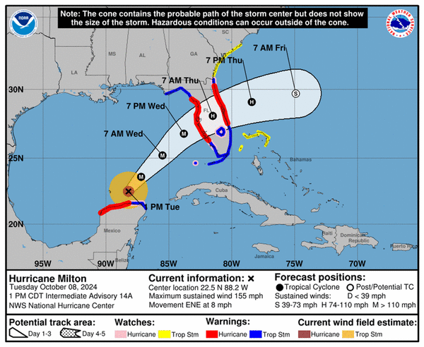
On Tuesday, much of Florida was hunkering down for the looming arrival of Hurricane Milton, a Category 5 hurricane that could deliver one of the most damaging strikes to the state in history.
After a brief dip overnight, Milton was back to Category 5 strength Tuesday evening, still on track to slam into the Gulf Coast somewhere near the heavily populated Tampa Bay region. The latest track ticked a bit south but that could change before landfall sometime late Wednesday or early Thursday.
Though the storm’s sustained winds had eased somewhat from a near-record 180 mph, it was still packing extremely powerful 165 mph winds, and Milton’s biggest threat remains unchanged. It was expected to push up to 15 feet of life-threatening storm surge across a huge swath of the coast, anywhere between Fort Myers Beach and Crystal River.
From there, Milton could plow a path of record-breaking damage across the state, whipping by the theme parks of Orlando as a Category 1 hurricane before exiting along the Space Coast. Forecasters cautioned that as Milton’s wind speed falls, likely to a Category 3 before landfall, the small storm will expand its size, sweeping its damaging winds across a broader area.
Forecasters expect the wind field of the now-compact storm to double by the time it comes ashore — bringing 125 mph sustained winds and higher gusts, plus record-setting storm surge, to much of Florida. Milton could also bring more than a foot of rain to areas north of its eye, up to 18 inches in some spots.
“You’re going to see flooding of homes and businesses, you’re going to see rescues. It will flood in areas that don’t normally flood,” said Mike Brennan, director of the National Hurricane Center, in a Tuesday morning broadcast. “I’m pleading with you to get out of those storm surge evacuation areas if you have not yet.”
That threat put almost the entire state, including Miami-Dade and Broward counties and the Florida Keys, under some sort of hurricane or tropical storm warning or watch. Southeast Florida could see tropical storm force gusts beginning Wednesday afternoon through Thursday morning, with flooding rains from Milton’s outer feeder bands.
Evacuations underway
At 5 p.m. Eastern time, there was a slight southern shift, with the center of the National Hurricane Center’s cone of concern aimed at Sarasota, just south of Tampa Bay, which is still reeling from the region’s worst storm in a century — Hurricane Helene — just two weeks earlier.
Milton, if it comes into the Bay, could be far worse. The latest estimates call for up to double the storm surge seen in Helene, which swamped tens of thousands of homes. As of the 8 p.m. update, storm surge may be between 8 to 12 feet in the Fort Myers area.
Forecasters said that exactly where the eye comes ashore matters for determining who gets the worst of the rain and storm surge, but the exact location will be hard to determine until the storm is very near. It may continue to windshield wiper up and down the coast as Milton closes in.
“It is still critical to remember that even at 36 hours (around the time of potential landfall), NHC’s track forecasts can be off by an average of 60 nautical miles, which means we still can’t pinpoint an exact landfall location, especially if additional wobbles occur in the short term,” the hurricane center stressed in the 5 p.m. update.
President Joe Biden said Tuesday he is postponing a diplomatic trip to Germany and Angola to help oversee his administration’s response to Hurricane Milton.
“This could be the worst storm to hit Florida in over a century,” Biden said at a news briefing. “God willing it won’t be, but that’s what it is looking like right now.”
FEMA Administrator Deanne Criswell said that Florida is in “good hands” and that the agency has enough funding to support the response efforts for Hurricanes Helene and Milton.
In a Tuesday morning press conference, Jared Perdue, head of Florida’s Department of Transportation, urged residents to leave as soon as possible if they were evacuating. Officials said traffic was up 150% on major highways, so the breakdown lanes on highways were open as extra lanes of traffic. Tolls were lifted for west-central Florida as evacuations were called in 14 counties.
“Unfortunately every storm we see traffic fatalities because people wait until the last minute to leave,” he said.
To address this, Gov. Ron DeSantis said the state planned to open at least four backup shelters of last resort near highways so that drivers stuck in traffic as the storm approaches have somewhere to go. These warehouses can hold thousands of people, he said, including up to 10,000 at one site.
Those counties are also working double-time to clear the streets of waterlogged appliances and furniture from Hurricane Helene before Hurricane Milton’s winds turn them into projectiles. The state has assigned hundreds of employees to help, and it plans to ask FEMA for permission to pay debris haulers even more to surge in from other states. However, DeSantis said, they can’t get to all of it.
“It may not have been humanly possible to have all the debris cleaned up from Helene before Milton hit, just because of how much there was,” he said.
On Tuesday morning, counties began shutting off water to barrier islands, including Siesta Key and Casey Key in Sarasota, to try and protect the water and sewer system. Pinellas County will “most likely” do the same with its sewage system, the Tampa Bay Times reported.
The governor warned residents that their window for preparations was shrinking, and everyone should be hunkered down by Wednesday morning.
“Let’s prepare for the worst and pray we get a weakening,” he said. “We must be prepared for a major, major impact on the west coast of Florida.”
Turn toward Florida begins
Milton, still about 440 miles southwest of Tampa, also began slowly gaining some latitude Tuesday, signaling that it may be starting its forecast turn to the northeast toward Florida. The NHC had pushed its projected landfall back slightly, possibly to the early morning hours on Thursday, but its impacts along the coast will be felt at least a day earlier.
On Monday, Milton exploded into a frightening Category 5 storm with 180 mph maximum sustained winds. Its barometric pressure — a measure of intensity — dropped to the fourth-lowest on record at one point.
“Milton has the potential to be one of the most destructive hurricanes on record for west-central Florida,” National Hurricane Center forecasters said.
Overnight, the storm underwent an eyewall replacement cycle, where a new, larger eye forms on the outskirts of the current one and eventually replaces it. The process tamps down wind speeds temporarily but grows the wind field.
Tuesday morning satellites found a slightly bigger Milton with just a single eye again — a sign the storm is ready to strengthen again. It regained Category 5 wind strength on Tuesday evening. But storm-shredding wind shear near Florida is still expected to bat it back to a Category 3 ahead of landfall.
“An expanding wind field, the angle of approach to the coast, and the formidable strength, all will lead to a deep & damaging surge in Florida,” wrote John Morales, a hurricane specialist at NBC6, on Twitter.
Riding it out in a mobile home
Mandatory evacuations were called in counties across the state, but most of them had one thing in common — do not wait out this storm if you’re in a mobile home.
“if you are in a mobile or a manufactured home, or in a low-lying home in a flood-prone area, it is never safe to stay in that situation,” Kevin Guthrie, the director of the state’s emergency management department, said in a Tuesday afternoon press conference. “No matter what year it was built, you need to evacuate.”
And yet, some Floridians are staying.
In Ruskin, an unincorporated area in southwest Hillsborough County, Primitivo Cesario and his family have spent the last few weeks shoring up their double-wide mobile home in the neighborhood of Fairmont Mobile Home Estates as best they could.
A rope linked to tie-down straps runs across the roof, each end fastened to mango trees. What looks like an additional room made of plywood walls sits in the front of the carport, meant to keep the structure standing. Repurposed closet doors and two-by-fours make an improvised wall further closing in the carport.
“You just don’t know what’s going to happen,” Cesario said, speaking in Spanish, as his kids and nephews munched on mangos and talked about how they were going to hide from the storm in their house.
“I don’t know if it is going to move up or down.”
Despite an evacuation order for all mobile homes in the county, they’re not leaving.
“The problem is if no one’s home, thieves come in and take people’s belongings,” said Silvestre Urbina, a relative who was there helping out.
The uncertainty of Milton’s path has this community on edge as some shreds of Helene’s damage still lay on the ground.
“I’m more concerned because I think this one is coming our way,” said Andres Alonso a few minutes after he and his nephew boarded up a window on their trailer home.
Alonso plans to make a call for him and his family, including his two young children, on Wednesday. He’ll move to a family member’s concrete block home five minutes away if the forecast pushes him.
_____
(Miami Herald Staff Writers Milena Malaver, Ana Ceballos and Devoun Cetoute contributed to this report.)
_____
©2024 Miami Herald. Visit at miamiherald.com. Distributed by Tribune Content Agency, LLC.


Comments