Hurricane Milton's might has Central Florida utilities prepared for worst
Published in Weather News
Will Hurricane Milton knock the lights out in Central Florida so ferociously that much of the region stews in the dark for a week — or longer — as with Hurricane Charley 20 years ago?
That’s the scenario residents should prepare for, according to the nation’s hurricane center and weather service, and it’s one that Duke Energy, Florida Power & Light Co., Orlando Utilities Commission and other electric utilities are ready to respond to.
“While it is difficult to predict the full extent, multi-day outages are anticipated and flooding is a concern,” OUC warned in a message Tuesday to customers. “Additionally, trees uprooted due to rain and wind could impact water pipes and disrupt service.”
But Charley, Ian and a number of other storms have shown that hurricanes can wobble to their destinations with the predictability of a lopsided bowling ball. Milton might turn out to be the worst ever for Orlando or something considerably less.
“It is critical to remember that even at 36-48 hours away, NHC’s track forecasts can be off by an average of 60-70 (miles), which means we still can’t pinpoint an exact landfall location,” the National Hurricane Center said Tuesday afternoon.
The National Weather Service, according to its hour-by-hour forecasting, is predicting that Milton will bring gusts of about 50 mph shortly after midnight Thursday morning and peak at about 9 a.m in the high 60 mph range.
That’s similar to Helene’s relatively tolerable hit on Orlando two weeks ago – but not the right way to think about how to prepare for Milton, according to the weather service.
“That’s not something we want to be messaging right now,” said Jessie Ruth Schaper, who described the service’s hour-by-hour forecasts as better suited for more ordinary weather and not an event as fickle and potentially deadly as Hurricane Milton.
“That might be a good tool to use as we get closer to Wednesday night,” Schaper said. “But when you’re in a tropical event like this, it’s not going to be your friend.”
The service’s Central Florida office is urging residents to prepare for sustained and destructive winds of as low as 74 mph to as catastrophic as 110 mph across Lake, Seminole, Orange and Osceola counties.
Much of that area also should brace for the potential of extreme flooding, according to the weather service.
“You should prepare for that and you should be good to go,” Schaper said.
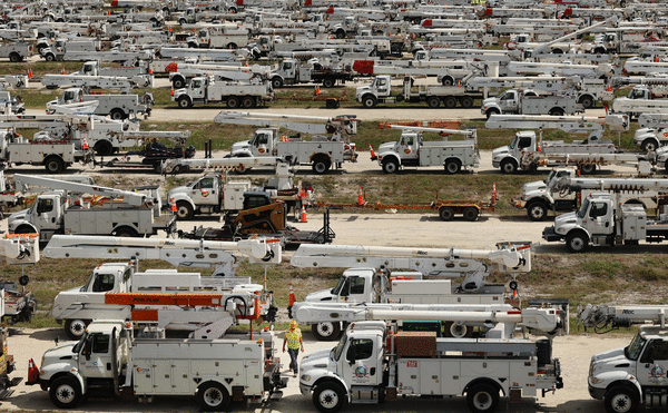
Duke Energy, the state’s second largest and Central Florida’s largest power provider, is digging in for a staggering amount of outage response. Milton is taking aim at the largest share of the utility’s 2 million Florida customers.
“We’ve got about 500,000 in Pinellas County alone,” said Duke spokeswoman Audrey Stasko of where some of the storm’s most extreme damage is expected. “We’ve got 430,000 customers in Orange County. With numbers like that, the outages are going to be substantial.”
Duke has assembled 16,000 power line specialists, personnel for removing tree debris and support workers from within the company and from utilities across the country at three sites adjoining Milton’s anticipated path of destruction.
The state’s largest electric utility, Florida Power & Light, has positioned 14,000 responders.
Orlando’s municipally owned utility has assembled its response army at an International Drive hotel.
The number of downed trees and the extent of the flooding will dictate much about the speed at which those three utilities and others are able to begin restoration work.
Stasko said Duke’s trucks can roll as soon as winds drop to below 40 mph.
One factor favoring power restoration: Unlike other major storms hitting Central Florida in recent years, Milton will pass through during daylight hours.
That will allow utilities to use their drones and other means to assess damage more quickly.
_____
©2024 Orlando Sentinel. Visit orlandosentinel.com. Distributed by Tribune Content Agency, LLC.


Comments