Odds drop for potential tropical system in Gulf, but Florida still likely to get drenched
Published in Weather News

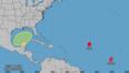
FORT LAUDERDALE, Fla. — The tropics remain active with a hurricane and a tropical storm in the Atlantic, but forecasters said concern is lessening about a potential system developing in the Gulf of Mexico.
A weather disturbance is expected to move into the Gulf, but the odds dropped to 30% for tropical development because of “interaction with a frontal boundary.”
Forecasters still warned that noting is certain and residents along the U.S. Gulf Coast should watch the disturbance closely.
“Should development take place in the southwestern gulf and move along a narrow east-northeast path toward the Florida Peninsula, there is the time and potential for the [disturbance] to strengthen into a tropical storm and hurricane,” AccuWeather Lead Hurricane Expert Alex DaSilva said.
And regardless of development, the system is carrying a lot of moisture that will move over Florida next week, bringing heavy rainfall to parts of the state already saturated by Hurricane Helene.
“While the exact track and intensity of the feature unfolding in the gulf have yet to be determined, Florida will bear the brunt this time around,” AccuWeather Chief On-Air Meteorologist Bernie Rayno said. “At this time, the intensity will range from a sprawling tropical rainstorm to perhaps a strike from a more compact, full-blown hurricane.”
As of 8 a.m. Thursday, unorganized showers and storms were associated with the disturbance. Though it’s too soon for forecasters to release a potential forecast track, water temperatures in the southeastern Gulf are high, both at the surface and deep down. Those temperatures could fuel development.
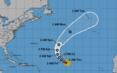
The system is one of three that the National Hurricane Center is watching in the Atlantic Basin.
The eastern Atlantic is active with both Hurricane Kirk and Tropical Storm Leslie.
Tropical Storm Leslie, located off Africa’s Cabo Verde Islands, is expected to become a hurricane in the next couple of days, the hurricane center said Thursday.
It has a maximum sustained wind speed of 40 mph and is moving west at 6 mph. Forecasters are projecting the five-day track to turn to the northwest, away from the Caribbean.
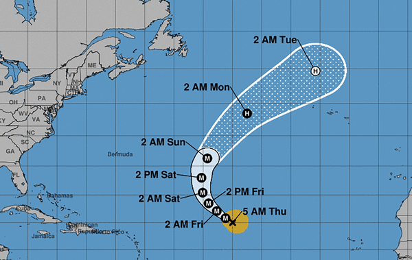
Meanwhile, Kirk is a “formidable” major hurricane, with top wind speeds peaking at 120 mph. Though Kirk is not near land, it is forecast to bring large swells to the U.S. East Coast by Sunday, according to the National Hurricane Center.
At 5 a.m. Thursday, the Category 3 storm was located about 1,185 miles east of the Lesser Antilles and was moving northwest at 10 mph.
Long-range forecasts show Kirk arcing north away from the Caribbean region and the U.S.
The next named storm will be Milton.
---------
©2024 South Florida Sun Sentinel. Visit at sun-sentinel.com. Distributed by Tribune Content Agency, LLC.


Comments