Weather
/Knowledge
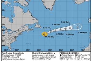
Hurricane center tracks 2 Atlantic systems while Tropical Storm Dexter becomes extratropical
The National Hurricane Center on Thursday said Tropical Storm Dexter had become extratropical, but continued to keep track of two developing Atlantic systems that could become the season’s next tropical depression or storm.
As of the NHC’s 2 p.m. Eastern time tropical advisory, closer to the the U.S. but moving away is what is now expected ...Read more

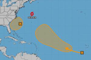
Hurricane center keeps tracking 2 Atlantic systems while TS Dexter becoming extratropical
The National Hurricane Center on Thursday forecast Tropical Storm Dexter to become extratropical, but continued to keep track of two developing Atlantic systems that could become the season’s next tropical depression or storm.
As of the NHC’s 8 a.m. tropical advisory, closer to the the U.S. but moving away was a weak area of low pressure a ...Read more
SoCal heat wave peaks today, but sweltering temps, fire risk will last for days
LOS ANGELES — The worst of Southern California's ongoing heat wave is expected to land Thursday, but relief is not yet in sight. Temperatures will remain toasty over the weekend, and another hot spell is forecast next week.
Temperatures will hit the triple digits in the San Fernando and Antelope valleys on Thursday, while interior regions of ...Read more
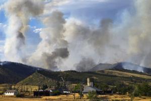
Colorado weather: Red flag, heat and smoke advisories active statewide
DENVER —Dangerous fire conditions, soaring temperatures and smoky skies across Colorado prompted severe weather alerts for parts of the Western Slope, Front Range and Eastern Plains on Wednesday.
Temperatures are expected to reach 100 degrees in Denver, Boulder, the western metro and Fort Collins, National Weather Service forecasters said in ...Read more

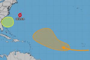
Hurricane center eyes 2 Atlantic systems along with Tropical Storm Dexter
ORLANDO, Fla. — The National Hurricane Center on Wednesday continued to keep track of Tropical Storm Dexter as well as two developing Atlantic systems that could become the season’s next tropical depression or storm.
As of the NHC’s 8 a.m. tropical advisory, the closest system to the U.S. was a weak area of low pressure that had formed ...Read more
Hurricane center increases odds system off Florida will develop amid Atlantic upsurge
ORLANDO, Fla. — The National Hurricane Center on Tuesday increased the chances an expected low pressure area off the northeast coast of Florida could develop into a tropical depression or storm while keeping an eye on another Atlantic system plus Tropical Storm Dexter.
As of the NHC’s 2 p.m. Eastern time tropical outlook, forecasters expect...Read more
Hurricane center increases odds system off Florida will develop amid Atlantic upsurge
ORLANDO, Fla. — The National Hurricane Center on Tuesday increased the chances an expected low pressure area off the northeast coast of Florida could develop into a tropical depression or storm while keeping an eye on another Atlantic system plus Tropical Storm Dexter.
As of the NHC’s 8 a.m. tropical outlook, forecasters expect a weak ...Read more
Hurricane center eyes potential systems near Florida, in Atlantic while TS Dexter churns
The National Hurricane Center on Monday increased the odds two systems could form into the season’s next tropical depression or storm, including one near Florida’s coast, while newly formed Tropical Storm Dexter continued to churn in the Atlantic.
As of the NHC’s 2 p.m. Eastern time tropical outlook, forecasters expect a broad area of low...Read more

Hurricane center eyes potential systems near Florida, in Atlantic while TS Dexter churns
ORLANDO, Fla. — The National Hurricane Center on Monday increased the odds two systems could form into the season’s next tropical depression or storm, including one near Florida’s coast, while newly formed Tropical Storm Dexter continued to churn in the Atlantic.
As of the NHC’s 8 a.m. tropical outlook, forecasters expect a broad area ...Read more

Hurricane center tracks 3 Atlantic systems that could develop
The National Hurricane Center continued Sunday to track three systems in the Atlantic with the potential to form into the season’s next tropical depression or storm.
As of the NHC’s 2 p.m. tropical outlook, it had increased chances for a system off the U.S. East Coast to form while also forecasting a tropical wave to roll off the African ...Read more
Hurricane center tracks 2 Atlantic systems that could develop
The National Hurricane Center continued Sunday to track two systems in the Atlantic with the potential to form into the season’s next tropical depression or storm.
As of the NHC’s 8 a.m. tropical outlook, it had increased chances for a system off the U.S. East Coast to form while also forecasting a tropical wave to roll off the African ...Read more
One dead from severe Charlotte-area storms. Thousands without power on Saturday
CHARLOTTE, N.C. — A driver died in a two-car wreck during intense storms that swept across the Charlotte region Friday night, a State Highway Patrol trooper said.
Gabriella Elise Cruz, 22, of Bryson City, died at the scene on Interstate 40 West in Claremont, Master Trooper Christopher Casey said in a news release.
An SUV driver collided with...Read more
Hurricane center watching disturbance near Carolinas
ORLANDO, Fla. — The National Hurricane Center on Saturday began watching a disturbance off the southeastern Atlantic coast near the Carolinas that has a chance to develop into the season’s next tropical depression or storm.
In the 2 p.m. advisory, forecasters said an area of low pressure could develop later Saturday or on Sunday.
“...Read more
Mayor Adams declares state of emergency amid NYC flash flood warning, water rescues
NEW YORK — A flash flood warning has been issued for Brooklyn, Manhattan and Staten Island with New York City Mayor Eric Adams declaring a state of emergency and the FDNY rescuing motorists stranded by rising waters.
The heavy rains are turning the evening commute into a nightmare, as flooding conditions necessitated the closure of several ...Read more

NYC mayor declares state of emergency amid flash flood warning, road closures
NEW YORK — A flash flood warning has been issued for Brooklyn, Manhattan and Staten Island until 6:15 p.m., with authorities warning people not to walk or drive where water covers the road, ensnarling commuters as extreme thunderstorms overtake NYC following a dangerous heatwave.
Mayor Eric Adams declared a state of emergency to allow ...Read more

Damaging, golf ball-size hail will fall more frequently because of climate change, researchers warn
During severe thunderstorms, rising air shoots icy pellets the size of Dippin’ Dots ice cream into the bitter cold of upper atmospheric layers. There, supercooled water freezes onto the small particles to form hail, which then falls when it gets too heavy for the storm’s upward draft.
As climate change warms average global temperatures, ...Read more
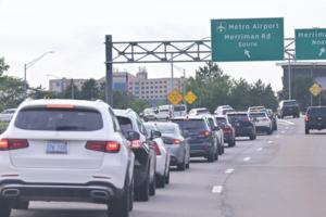
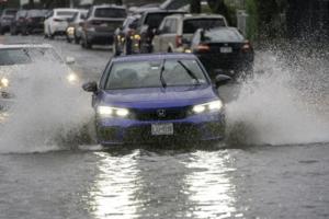
Storms cause flash floods in Metro Detroit, cut power to thousands
Storms with heavy rain caused flash flooding across Metro Detroit early Monday evening, delaying flights at Detroit Metro Airport and leaving thousands of electricity customers without power statewide.
The Wayne County Airport Authority reported flooding at "several locations across the Detroit Metro Airport campus, including the Dingell Drive ...Read more
Searing heat threatens grids and health over nearly half the US
Nearly half the U.S. will wilt under hot, sticky conditions through the bulk of the week as temperatures and humidity soar from Chicago to New York City and New Orleans, boosting power demand and raising health risks.
Heat advisories and extreme heat warnings stretch from Nebraska to Long Island and from New Hampshire to northeast Texas.
...Read more
Tampa hits 100 degrees for 1st time in recorded weather history
TAMPA, Fla. -- Tampa temperatures climbed into triple digits for the first time in recorded weather history on Sunday.
Air temperatures read 100 degrees at Tampa International Airport, the National Weather Service’s Tampa Bay office wrote in a post Sunday about 3:30 p.m. on X.
Sunday’s heat broke the previous record of 99 degrees set on ...Read more
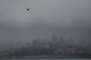
City by the Bay? More like City by the Brrr! San Francisco is having its coldest summer in decades
Time to cue that famed quote, often falsely attributed to Mark Twain: "The coldest winter I ever spent was a summer in San Francisco."
It's a cliche, sure. But this year it rings true. It really has been quite chilly in the City by the Bay, which is experiencing its coldest summer in decades, with no significant warm-up in sight and daytime ...Read more
Popular Stories
- SoCal heat wave peaks today, but sweltering temps, fire risk will last for days
- Hurricane center tracks 2 Atlantic systems while Tropical Storm Dexter becomes extratropical
- Hurricane center keeps tracking 2 Atlantic systems while TS Dexter becoming extratropical
- Colorado weather: Red flag, heat and smoke advisories active statewide
- Hurricane center eyes potential systems near Florida, in Atlantic while TS Dexter churns
Comics