Weather
/Knowledge

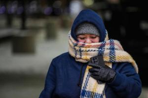
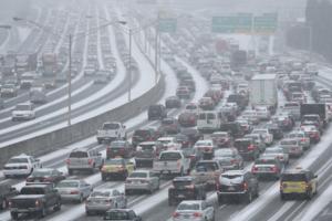
Frigid subzero weather grips Chicago on 40-year anniversary of record low
CHICAGO — Forty years ago today, temperatures in Chicago dipped to an all-time low of minus 27 degrees. The cold stretched to D.C., where it forced Ronald Reagan’s presidential inauguration ceremony indoors.
As a blast of Arctic air hits most of the country, Donald Trump is being sworn in as president inside the Capitol on Monday because of...Read more
January chill: Las Vegas Valley to feel coldest temperatures in 2 years
LAS VEGAS — While it won’t be anywhere close to bone-chilling cold that is forcing Monday’s presidential inauguration indoors, Southern Nevadans will feel the coldest weather in more than two years early next week.
The current Tuesday morning forecast low for Harry Reid International Airport is 31, according to National Weather Service ...Read more
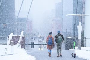
New York City to get blasted by snowstorm, arctic air
NEW YORK — After days of balmy weather, New York City is slated to get buried in snow and then hit with an arctic blast expected to unleash a potentially life-threatening chill.
With a frigid polar vortex set to grip huge swaths of the U.S. in the coming days, the city could see anywhere between 3 and 5 inches of snow before the quick-moving ...Read more
New York City to get blasted by arctic air, snow this weekend
NEW YORK — After days of balmy weather, New York City is slated to get hit with snow and then blasted by frigid cold by weekend’s end.
Saturday morning started off cloudy and is set to turn soggy by the afternoon. Highs for the day are expected to peak around 45, which means any precipitation city dwellers see will be rain, rather than snow...Read more

Wintry blast to unleash snow, test grids from Midwest to NYC
An extended run of bone-chilling cold is poised to send demand for power and natural gas surging across much of the United States this weekend, with snow expected in the Northeast by Sunday and a chance of snow or sleet along the Gulf Coast early next week.
Frigid weather has already begun to set in across the Central U.S. By Monday, daily ...Read more
Frigid Arctic air headed to metro Atlanta. But will it snow?
ATLANTA — Enjoy the next couple of days, because temperatures across metro Atlanta will plunge into the teens starting Sunday night.
What everyone wants to know, though, is whether the region will get another round of snow next week.
The quick answer? As of the latest forecast Friday, it’s not looking very favorable for snow closer to the ...Read more

Extreme cold from NY to Texas threatens to topple records
A blast of extreme cold is poised to descend on the central U.S. this weekend before spreading to New York and the rest of the East Coast, testing power grids and threatening to break temperature records.
Frigid conditions will sweep the Midwest and South, including Texas, starting on Saturday and then shift east early next week. The low in ...Read more
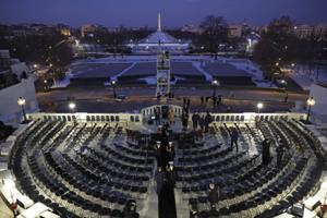
Trump's second Inauguration Day will be one of the coldest on record
As America anticipates the second inauguration of President-elect Donald Trump on Monday, Jan. 20, weather forecasters say this swearing-in ceremony will be one of the coldest on record.
Though the sun will be out, most Washington, D.C. forecasts expect an afternoon high temperature in the mid-20s. Sustained winds of around 15 mph and gusts of ...Read more
Bone-chilling cold from NY to Texas threatens to topple records
A blast of extreme cold is poised to descend on the central U.S. this weekend before spreading to New York and the rest of the East Coast, testing power grids and threatening to break temperature records.
Frigid conditions will sweep the Midwest and South, including Texas, starting on Saturday and then shift east early next week. The low in ...Read more
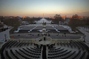
Monday set to be coldest Inauguration Day since 1985
Subfreezing temperatures are expected for President-elect Donald Trump’s upcoming inauguration in Washington, D.C.
The Weather Channel predicts a high of just 26 degrees on Monday, with low temperatures dropping into the single digits. Clear skies and daytime winds of up to 20 mph could add to the chill.
It’s set to be the coldest ...Read more
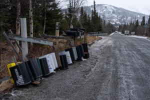
Anchorage power outages extend to 3rd day in wake of 'extreme' warm January storm
ANCHORAGE, Alaska — Hundreds of Anchorage residents remained without power for a third day following a rare January storm that brought record warmth and hurricane-force winds over the weekend.
Chugach Electric Association said the extensive repairs necessitated by Sunday's storm means some members may not get power back until Wednesday.
The ...Read more
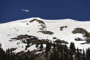
Colorado to double arsenal of mountainside avalanche blasters in war against highway-covering snow slides
DENVER — Colorado transportation officials plan to nearly double the number of remotely controlled avalanche blasters installed on mountain ridges above highways, a project estimated to cost taxpayers tens of millions of dollars to prevent potentially catastrophic snow slides.
They’ve settled on a strategy of firing these blasters at night ...Read more
Denver weather: “Arctic” cold headed for city, windchill temps to hit 30 below zero
DENVER — Bundle up, Colorado! Subzero temperatures, wind and snow are headed for Denver this weekend, according to the National Weather Service.
Light snow was already falling in northern Colorado’s mountains on Tuesday morning, NWS forecasters said. That snow is expected to make its way into Denver and across the Eastern Plains on Friday, ...Read more
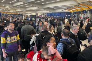
Hundreds of Delta flights canceled Saturday, long lines and crowds fill Atlanta airport
Atlanta-based Delta Air Lines canceled more than 370 flights Saturday, and long lines of travelers waiting to go through security stretched through Atlanta's Hartsfield-Jackson International Airport’s domestic terminal and baggage claim areas.
The disruptions were the fallout of Delta’s struggles during a Friday winter storm at its Atlanta ...Read more

Local governments in Georgia say they have learned from 'snowpocalypse'
ATLANTA — More than two inches of snow fell in metro Atlanta on a Friday in January, 11 years ago. It began late in the morning, when hundreds of thousands of students were in schools and many of the region’s 2.6 million workers were in their places of employment.
And on that day — Jan. 28, 2014 — almost everyone tried to go home around...Read more
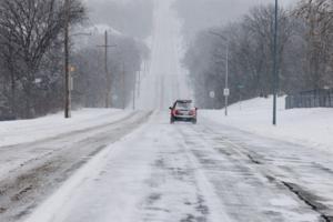
Winter storm to bring more snow to Kansas City
Snow is now expected to reach the Kansas City metro from a winter storm pushing across the southern United States overnight Thursday, according to the National Weather Service.
While initial forecasts indicated the metro would likely only see a dusting with minimal overall impacts, the weather service reported that Kansas City’s chance of ...Read more
Georgia Gov. Brian Kemp issues state of emergency ahead of Friday's winter storm
ATLANTA — Gov. Brian Kemp has issued a state of emergency ahead of the severe winter weather expected to start in metro Atlanta in the overnight hours, though forecasts are now calling for less snow to reach the area.
Still, freezing temperatures could lead to slick, hazardous road conditions.
The state of emergency, which coincides with one...Read more
Local governments in Georgia say they have learned from 'snowpocalypse'
ATLANTA — More than two inches of snow fell in metro Atlanta on a Friday in January, 11 years ago. It began late in the morning, when hundreds of thousands of students were in schools and many of the region’s 2.6 million workers were in their places of employment.
And on that day — Jan. 28, 2014 — almost everyone tried to go home around...Read more
Winter storm watch issued, snow expected in metro Atlanta later this week
ATLANTA — The National Weather Service has issued a winter storm watch for Friday morning as North Georgia and metro Atlanta brace for snow later this week.
“Expect significant accumulations of snow, sleet and freezing rain that will lead to hazardous travel conditions,” the agency warned Wednesday morning.
The winter storm watch will be...Read more
Popular Stories
- January chill: Las Vegas Valley to feel coldest temperatures in 2 years
- Frigid subzero weather grips Chicago on 40-year anniversary of record low
- New York City to get blasted by snowstorm, arctic air
- Georgia Gov. Brian Kemp issues state of emergency ahead of Friday's winter storm
- Winter storm to bring more snow to Kansas City
Comics