Weather
/Knowledge

Hurricane center tracks 3 Atlantic systems that could develop
The National Hurricane Center continued Sunday to track three systems in the Atlantic with the potential to form into the season’s next tropical depression or storm.
As of the NHC’s 2 p.m. tropical outlook, it had increased chances for a system off the U.S. East Coast to form while also forecasting a tropical wave to roll off the African ...Read more
Hurricane center tracks 2 Atlantic systems that could develop
The National Hurricane Center continued Sunday to track two systems in the Atlantic with the potential to form into the season’s next tropical depression or storm.
As of the NHC’s 8 a.m. tropical outlook, it had increased chances for a system off the U.S. East Coast to form while also forecasting a tropical wave to roll off the African ...Read more
One dead from severe Charlotte-area storms. Thousands without power on Saturday
CHARLOTTE, N.C. — A driver died in a two-car wreck during intense storms that swept across the Charlotte region Friday night, a State Highway Patrol trooper said.
Gabriella Elise Cruz, 22, of Bryson City, died at the scene on Interstate 40 West in Claremont, Master Trooper Christopher Casey said in a news release.
An SUV driver collided with...Read more
Hurricane center watching disturbance near Carolinas
ORLANDO, Fla. — The National Hurricane Center on Saturday began watching a disturbance off the southeastern Atlantic coast near the Carolinas that has a chance to develop into the season’s next tropical depression or storm.
In the 2 p.m. advisory, forecasters said an area of low pressure could develop later Saturday or on Sunday.
“...Read more
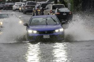
Mayor Adams declares state of emergency amid NYC flash flood warning, water rescues
NEW YORK — A flash flood warning has been issued for Brooklyn, Manhattan and Staten Island with New York City Mayor Eric Adams declaring a state of emergency and the FDNY rescuing motorists stranded by rising waters.
The heavy rains are turning the evening commute into a nightmare, as flooding conditions necessitated the closure of several ...Read more

NYC mayor declares state of emergency amid flash flood warning, road closures
NEW YORK — A flash flood warning has been issued for Brooklyn, Manhattan and Staten Island until 6:15 p.m., with authorities warning people not to walk or drive where water covers the road, ensnarling commuters as extreme thunderstorms overtake NYC following a dangerous heatwave.
Mayor Eric Adams declared a state of emergency to allow ...Read more

Damaging, golf ball-size hail will fall more frequently because of climate change, researchers warn
During severe thunderstorms, rising air shoots icy pellets the size of Dippin’ Dots ice cream into the bitter cold of upper atmospheric layers. There, supercooled water freezes onto the small particles to form hail, which then falls when it gets too heavy for the storm’s upward draft.
As climate change warms average global temperatures, ...Read more

Storms cause flash floods in Metro Detroit, cut power to thousands
Storms with heavy rain caused flash flooding across Metro Detroit early Monday evening, delaying flights at Detroit Metro Airport and leaving thousands of electricity customers without power statewide.
The Wayne County Airport Authority reported flooding at "several locations across the Detroit Metro Airport campus, including the Dingell Drive ...Read more
Searing heat threatens grids and health over nearly half the US
Nearly half the U.S. will wilt under hot, sticky conditions through the bulk of the week as temperatures and humidity soar from Chicago to New York City and New Orleans, boosting power demand and raising health risks.
Heat advisories and extreme heat warnings stretch from Nebraska to Long Island and from New Hampshire to northeast Texas.
...Read more
Tampa hits 100 degrees for 1st time in recorded weather history
TAMPA, Fla. -- Tampa temperatures climbed into triple digits for the first time in recorded weather history on Sunday.
Air temperatures read 100 degrees at Tampa International Airport, the National Weather Service’s Tampa Bay office wrote in a post Sunday about 3:30 p.m. on X.
Sunday’s heat broke the previous record of 99 degrees set on ...Read more

City by the Bay? More like City by the Brrr! San Francisco is having its coldest summer in decades
Time to cue that famed quote, often falsely attributed to Mark Twain: "The coldest winter I ever spent was a summer in San Francisco."
It's a cliche, sure. But this year it rings true. It really has been quite chilly in the City by the Bay, which is experiencing its coldest summer in decades, with no significant warm-up in sight and daytime ...Read more

Saharan dust plume to linger over South Florida this weekend, forecasters say
MIAMI — A plume of Saharan dust is blanketing South Florida this weekend, resulting in hazy skies, diminished air quality and lower-than-normal chances for rain, according to the National Weather Service in Miami.
The dusty air, originating from the Saharan Desert in Africa, is a regular seasonal occurrence that travels thousands of miles ...Read more
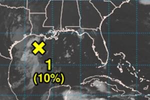
Hurricane center says Gulf system near Louisiana has small chance to develop
ORLANDO, Fla. — The National Hurricane Center continued Friday to track a low pressure system in the Gulf that could develop into the season’s next tropical depression or storm.
As of the NHC’s 8 a.m. tropical advisory, the broad area of low pressure was about 100 miles south of the coast of southwestern Louisiana disorganized showers and...Read more
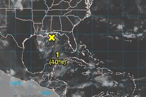
Hurricane center says Gulf system has small chance to develop
The National Hurricane Center continued Thursday to track a low pressure system that had moved into the Gulf after passing over Florida that could develop into the season’s next tropical depression or storm.
As of the NHC’s 2 p.m. Eastern time tropical advisory, the trough of low pressure had made it into the north-central Gulf with a broad...Read more
Hurricane center says Gulf system has small chance to develop
ORLANDO, Fla. — The National Hurricane Center continued Thursday to track a low pressure system that had moved into the Gulf after passing over Florida that could develop into the season’s next tropical depression or storm.
As of the NHC’s 8 a.m. tropical advisory, the trough of low pressure had made it into the north-central Gulf with a ...Read more

Trump OKs disaster declaration after northern Michigan ice storm
LANSING, Mich. — President Donald Trump has approved Michigan's request for a disaster declaration to help with the cost of cleanup efforts after a historic ice storm wiped out power for thousands in Northern Michigan.
Neither Trump, in a Federal Emergency Management Agency release, nor Gov. Gretchen Whitmer gave a dollar amount regarding ...Read more
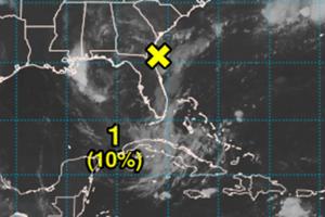
Hurricane center says system moving across Florida could develop in Gulf
The National Hurricane Center continued Wednesday to track a low pressure system near Florida that could move west into the Gulf and develop into the season’s next tropical depression or storm.
As of the NHC’s 8 p.m. Eastern time tropical advisory, the trough of low pressure stretched into northern Florida and continues to produce scattered...Read more

Fort Worth man shares survival story after escaping Hill Country floods
FORT WORTH, Texas — The sounds of thunder and rushing water woke up campers and residents as the swollen Guadalupe River ripped cabins, homes and office buildings out of the ground, catching hundreds people off guard.
One of them was Christian Fell of Fort Worth. Water had rushed in his family’s vacation home, and now he was trying to reach...Read more

Trump denies FEMA funding for Western Maryland floods
President Donald Trump denied disaster assistance for Western Maryland on Wednesday that Gov. Wes Moore requested following massive floods that hit the region in May.
In a statement Wednesday, Moore, a Democrat, said that the flooding, which caused evacuations in Garret and Allegany counties after Georges Creek overflowed following three days ...Read more

Dangerous heat in Chicago to last through Thursday night, weather officials say
CHICAGO — Stifling heat and humidity will cover the Chicago area from Wednesday morning through Thursday evening, according to forecasters.
On both days, temperatures are expected to reach the mid to high 90s, with afternoon heat indexes between 100 and 110 degrees. The National Weather Service has placed a heat advisory in effect from 10 a.m...Read more
Popular Stories
- One dead from severe Charlotte-area storms. Thousands without power on Saturday
- Hurricane center tracks 2 Atlantic systems that could develop
- Hurricane center watching disturbance near Carolinas
- Hurricane center tracks 3 Atlantic systems that could develop
- Mayor Adams declares state of emergency amid NYC flash flood warning, water rescues
Comics