Park Fire explodes in Northern California. Wildfire 45,000 acres amid evacuations near Chico
Published in Science & Technology News
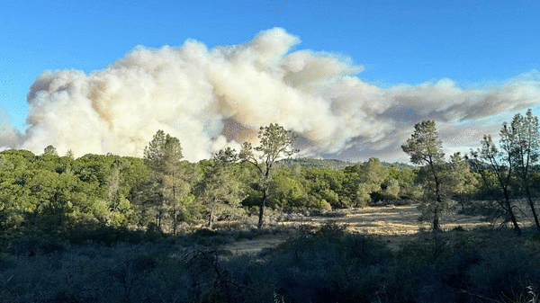
A Northern California blaze exploded Thursday to more than 45,000 acres — the largest wildfire in California this year — spanning two counties, as residents were ordered to evacuate areas north of Chico.
Firefighters have contained just 3% of a 45,550-acre blaze dubbed the Park Fire burning across Butte and Tehama counties after sparks ignited Wednesday in the open spaces of Upper Bidwell Park on the outskirts of Chico. More than 216 personnel are battling the flames that consumed structures as Incident Management Team 3 was tasked to take over command later this morning.
The Butte County Sheriff’s Office ordered the evacuation of areas around Musty Buck Ridge as wind spurred flames toward Cohasset, a community of 900 residents. Winds billowed up to 20 mph, with gusts reaching 23 mph, in Upper Bidwell Park about 8 p.m. Wednesday, according to the National Weather Service.
Firefighters and residents acted quickly to dodge the flames as the fire made Cohasset Road impassable. Authorities led a group of 20 vehicles uphill toward Campbellville to safety. Another 80 vehicles were guided by trucks on small logging roads in Sierra Pacific Industries forest lands, according to radio dispatches reviewed Wednesday night by The Sacramento Bee. Cameras operated by PG&E in the AlertCalifornia wildfire surveillance network showed flames devouring a communications tower along Richardson Springs Road as flames raced through river canyons and over ridges. The transmission cut out a few moments later.
Flames on Wednesday reached 6,465 acres at about 10:30 p.m. but grew more than seven times larger by Thursday morning. The rapid spread of the blaze was due in part to the fire burrowing into heavily inaccessible parts, said Capt. Dan Collins, a spokesman for Cal Fire and Butte County Fire Department.
Deploying ground resources to those heavily wooded parts proved “challenging” especially as flames charred regions with little to no fire history, Collins said. The vegetation provided lots of fuel for embers to ignite, especially as high temperatures raged, he said. Collins didn’t have a total number of structures that have burned.
Gusts could reach 21 mph Thursday in Chico, with an estimated high of 102 degrees, according to the National Weather Service.
The Butte County Sheriff’s Office placed the following zones were under evacuation orders: 120, 149, 150-A, 250, 251-253, 260, 261, 262, 265, 266, 268, 269, 271, 311, 312, 317 and 318. It includes areas of Forest Ranch, Cohasset and Carpenter ridges. The area also includes the Chico Municipal Airport.
The following zones were under evacuation warnings in Butte County: 252 and 253, 273, 314, 315 and 316.
The Tehama County Sheriff’s Office ordered zones 736, 854, 856, 858, 882, 882-A and 882-B to leave the area. Residents in zones 726, 728, 732, 734 and 852 were under an evacuation warning.
An evacuation center was set up at Neighborhood Church, 2801 Notre Dame Blvd. in Chico. Small animals may be taken to a shelter at 2279 Del Oro Ave., in Oroville and large animals can be brought to safety at Camelot Equestrian Park, 1985 Clark Road in Oroville.
The California Highway Patrol’s office in Susanville closed Highway 32 at Highway 36 due to the fire with no estimated time of reopening. More resources from around Northern California expected to descend on the region to douse flames, according to Cal Fire.
The cause is under investigation, Cal Fire said.
____
©2024 The Sacramento Bee. Visit at sacbee.com. Distributed by Tribune Content Agency, LLC.


Comments