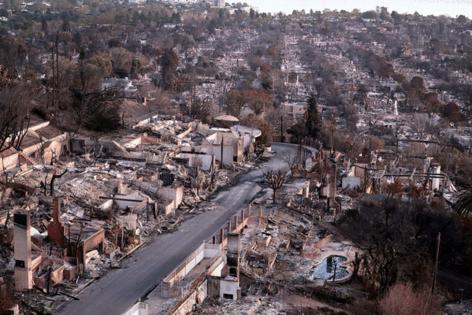
Some residents allowed to return to devastated Pacific Palisades, Altadena neighborhoods
Published in News & Features
With fire containment improving and winds dying down, some residents are being allowed back into neighborhoods devastated by the Eaton and Palisades fires.
Officials estimate that the fires have destroyed more than 12,000 structures, including many homes, making them two of the most destructive — and deadliest — wildfires in California history. More than 8,600 firefighters are working the fires, with the focus over the next several days on constructing containment lines and extinguishing hot spots to prevent the fires from spreading.
In the Palisades fire area, officials reopened the areas north of Topanga Canyon Boulevard and south of Mulholland Drive; north of Old Topanga Canyon Road and south of Summit to Summit Motorway; north of Mulholland Highway and south of Stokes Canyon Road and north of Red Rock Road and south of Calabasas Peak Motorway.
In the Eaton fire area, residents that live along Canyon Crest Road into the Meadows community east of El Prieto Road were allowed to return beginning at 3 p.m.
“A soft closure means the area is closed to the general public,” the L.A. County Sheriff’s Department said in a statement. “It is still open to disaster crews, public safety personnel, and residents with identification only. Only residents with valid proof of residence — driver’s license, registration, utility bills, etc. — are allowed to enter and exit the soft closure area.”
City of Los Angeles
LOS-Q0765: North of Mulholland Drive and south of Adlon Road
LOS-Q1118: North of Mulholland Drive and south of Hayvenhurst Drive
LOS-Q0798: South of Mulholland Drive
LOS-Q0782-B: South of Mission Dump Road
LOS-Q0778-A: East of Canyonback Road
LOS-Q0781-A: East of Canyonback Road near Mountaingate Drive
LOS-Q0782-A: Area east of Mt. Saint Mary’s Fire Road
LOS-Q0780: Area east of North Kenter Avenue
Los Angeles County
DRY-U026-A: North of Mulholland Highway and south of Stokes Canyon Road
RRC-U027-A: North of Red Rock Road and south of Calabasas Peak Motorway
TOP-U002: North of Old Topanga Canyon Road and south of Summit to Summit Motorway
TOP-U001: North of Topanga Canyon Boulevard and south of Mulholland Drive
For the Eaton fire, Altadena residents who live along Canyon Crest Road into the Meadows east of El Prieto Road can also reenter the area with identification.
The specific zones are as follows:
ALD-MEADOWS
ALD-MILARD B
ALD-MILARD C
Entry and exit points will be at the intersection of Canyon Crest Road and Lincoln Avenue.
Winds are expected to continue dissipating this week, but it’s shaping up to be a short reprieve for the region. There’s growing risk that significant fire weather could return to Los Angeles and Ventura counties starting early next week. The region is also facing continued danger from extreme dry conditions and lack of rain.
The Eaton fire, which burned though Altadana and surrounding neighborhoods, was 65% contained as of Friday morning. The fire has not grown in size since Jan. 10 when the California Department of Forestry and Fire Protection listed it as 14,117 acres. Since then, crews have been working to surround the fire, secure defenses and keep it from growing past their lines.
Similarly, the Palisades fire’s size has remained listed at 23,713 acres since Sunday as crews from far and wide have flowed into the fire zone and constructed a perimeter around it. The fire’s containment has increased from 11% on Sunday to 31% as of Friday morning, meaning firefighters are confident that nearly a third of the fire’s perimeter won’t go past their defenses.
As the search through the rubble continues, the number of confirmed deaths in the fires climbed to at least 27.
©2025 Los Angeles Times. Visit at latimes.com. Distributed by Tribune Content Agency, LLC.


Comments