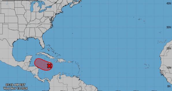
A depression could form in Caribbean, become Sara and move toward Florida. What to know
Published in News & Features
MIAMI — A new tropical depression could form soon in the Caribbean Sea, and there’s a chance it could strengthen into the season’s next tropical storm.
The National Hurricane Center has continued to increase the formation chances of the disturbance that is dumping rain over the central Caribbean Sea near Jamaica. The system now has a 90% chance of formation through the next 48 hours.
Forecasters say environmental conditions are friendly enough for the system to likely strengthen into a tropical depression in the next couple of days as it moves slowly west over the open water.
The system could strengthen even more as it meanders over the western Caribbean Sea this weekend before slowly turning northwest, according to the hurricane center.
Fox weather specialist Bryan Norcross on X Wednesday said the system will likely strengthen into a tropical storm in the next few days and has a “decent chance” of turning into a hurricane by early next week.
“Interaction with land looks like the only deterring factor,” Norcross wrote.
If the system were to strengthen into a storm, it would become Sara, the 18th named storm of the season. But there’s still a lot of uncertainty surrounding the system’s possible track and intensity.
If Tropical Storm Sara forms, where could it go?
Forecasters say it’s still too soon to know where the system is going, how strong will it be, or what impact it could bring. It has a high 90% chance of formation through the next seven days.
“Fronts will keep this developing system meandering over the Caribbean Sea through Sunday, so what will happen next?” WSVN Meteorologist Vivian Gonzalez wrote on X early Wednesday. “A lot of things can change with another front crossing through the U.S. & that means a variety of scenarios will come into play next week.”
A graphic Gonzalez posted shows a variety of potential scenarios. Some spaghetti models suggest the system could make landfall in Central America. Other models show the system heading toward Cuba, putting it in the general direction of South Florida. Still others show it moving over the Yucatan Peninsula, into the Gulf of Mexico, toward Florida’s Gulf Coast.
The bottom line: There’s too much uncertainty on where the system will go, but people in Florida should keep monitoring it.
While it’s too soon to know if the storm will track toward Florida, it’s also unclear which part of the state would be affected if it does, according to Norcross.
“A tiny difference in the angle of the steering flow or the location of likely-Sara when it enters the Gulf could drastically change the landfall point from South Florida to the Panhandle. It’s impossible to be more precise right now,” Norcross said on FoxWeather.
What is clear: “Regardless of development, heavy rains are expected over Jamaica during the next day or so,” according to the hurricane center’s Wednesday morning advisory.
“Interests across the western and northwestern Caribbean Sea should monitor the progress of this system,” the hurricane center said.
The 2024 Atlantic hurricane season officially ends Nov. 30.
©2024 Miami Herald. Visit at miamiherald.com. Distributed by Tribune Content Agency, LLC.


Comments