Growing Tropical Storm Rafael forecast to become hurricane, warnings issued for Florida Keys
Published in News & Features
ORLANDO, Fla. — The National Hurricane Center forecasts Tropical Storm Rafael to grow into the season’s 11th hurricane Tuesday as it moves toward Cuba with winds and storm surge expected to affect the Florida Keys this week.
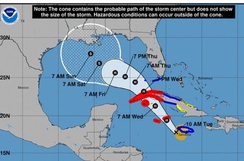
As of the NHC’s 4 p.m. Eastern time advisory, Rafael was located about 105 miles east of Grand Cayman and 120 miles west-northwest of Montego Bay, Jamaica moving northwest at 15 mph with maximum sustained winds of 70 mph. Tropical-storm-force winds extend out up to 115 miles from its center.
A tropical storm warning is now in effect for the lower and middle Florida Keys from Key West to west of the Channel 5 Bridge and for the Dry Tortugas.
A hurricane warning remains in effect for the Cayman Islands and Cuban provinces of Pinar del Rio, Artemisa, La Habana, Mayabeque, Matanzas and the Isle of Youth. A tropical storm warning is also in effect for the Cuban provinces of Villa Clara, Cienfuegos, Sancti Spiritus and Ciego de Avila.
The system is forecast to move near or over the Cayman Islands by Tuesday night and near western Cuba on Wednesday and then move into the southeastern Gulf of Mexico by Wednesday night.
“Steady to rapid intensification is expected during the next 24 hours or so, and Rafael is expected to become a hurricane during the next several hours as it passes near the Cayman Islands with further strengthening before it makes landfall in Cuba,” forecasters said.
The NHC’s intensity forecast has it reaching Category 1 strength with 90 mph sustained winds and 115 mph gusts with its center less than 100 miles west of the Dry Tortugas on Thursday morning, although the cone of uncertainty falls close to the island.
Its wind field and northeastern quadrant rain could have an effect on Southwest Florida beginning Wednesday, but the National Weather Service in Miami gives only a 30-40% chance of tropical-storm-force winds along coastal Collier County, and 2-3 inches of rain as a worst-case scenario, totals that could be seen in the middle and lower Keys especially.
“There is a limited tornado threat, with the primary area of concern being over interior and southwest portions of the region,” NWS forecasters said. “The presence of enhanced storm relative helicity coupled with moderate instability may allow for a few tornadoes to spawn.”
Marine hazards remain the primary concern for the Gulf Coast.
Storm surge is projected to range from 1-3 feet in the Dry Tortugas and 1-2 feet in the lower Florida Keys.
Immediate concerns for the Caribbean include rainfall totals could reach more than 10 inches over Jamaica and Cuba through midweek with the threat of flash flooding and mudslides.
Once it makes it into the Gulf of Mexico, its final destination along the Gulf Coast remains uncertain, with the five-day forecast track still with a wide range of potential from Texas to the far western Florida panhandle.
“It is too soon to determine what, if any, impacts Rafael could bring to portions of the northern Gulf Coast. Residents in this area should regularly monitor updates to the forecast,” forecasters said.
Its intensity, though, should drop from hurricane strength before landfall with drier air and stronger vertical wind shear present in the central Gulf of Mexico.
The NHC also continued to track a trough of low pressure that is producing disorganized showers and thunderstorms to the east-northeast of the Caribbean’s Leeward Islands.
“Portions of this system are forecast to move westward during the next day or so and could form a low pressure near the northern Leeward by Thursday,” forecasters said. “Afterward, some slow development of this system is possible during the latter part of the week while it moves generally westward over the southwestern Atlantic.”
The NHC gives it a 10% chance to develop in the next two days and 30% in the next seven days.
The 2024 Atlantic hurricane season has now produced 17 named storms, with 11 of the systems having grown into hurricanes, three of which have struck Florida’s Gulf Coast.
The official hurricane season runs through Nov. 30.
©2024 Orlando Sentinel. Visit at orlandosentinel.com. Distributed by Tribune Content Agency, LLC.


Comments