Cuba could see Category 2 hurricane within days. Impact on Florida appears minimal for now
Published in News & Features
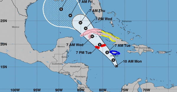
A hurricane could enter the Gulf of Mexico as soon as Wednesday, after striking western Cuba and the Cayman Islands.
The outer bands could sweep the Florida Keys and send some rain over the peninsula later in the week, but the initial forecast track kept the core of the still-developing system far from a Florida Gulf Coast still cleaning up from Hurricanes Helene and Milton.
As of the 4 p.m. EST update from the National Hurricane Center, Tropical Storm Rafael — the 17th named storm of the season — formed.
From there, the forecast takes Rafael past Jamaica, which remains under a tropical storm warning, and the Caymans, which remain under a hurricane warning, on Tuesday. The lower Florida Keys and Dry Tortugas are under a tropical storm watch.
This area of the Caribbean is still toasty warm, and forecasters say that the hot waters and low wind shear could help the storm strengthen up to a Category 1 hurricane as soon as Wednesday, and potentially a Category 2 before it hits Cuba. Western Cuba was under a hurricane watch and central Cuba was under a tropical storm warning on both coasts.
While forecasters say they’re more confident the system will steer clear of Florida — thanks to a high-pressure system near and to the east of the peninsula — the weather patterns steering the storm once it’s in the Gulf are a little harder to predict. The latest forecast takes Tropical Storm Rafael closer to Louisiana for a potential landfall.
“It should be noted that the track forecast over the Gulf of Mexico is of lower confidence,” forecasters wrote in the 4 p.m. Monday update.
However, they noted, the Gulf of Mexico has finally started to cool off. And the competing weather patterns have brought some storm-shredding wind shear and dry air to the area, which is likely to limit Rafael’s strengthening.
The latest forecast takes Rafael back to a Category 1 hurricane when it finishes crossing Cuba and down to a tropical storm as it nears the Gulf coast.
Long-range computer models do suggest that Florida will likely not see direct impacts from the storm, but they differ some in where eventual landfall could occur. The latest models are outdated and subject to change because they were run before the storm had a clearly defined center, which makes it easier for weather models to predict where they’ll go.
South Florida impacts
For Florida, the impacts of the storm are unclear this far out, said the Miami office of the National Weather Service. The chance for tropical storm winds over the peninsula is low — about 10 to 20%.
As of Monday morning, meteorologists said, South Florida could see up to 2 inches of rain on Wednesday, leading to a low level of flood risk across the southern part of the state for that day.
Other systems to watch
The hurricane center is also watching a tropical disturbance that could form north of Cuba and Haiti in the next week. As of 1 p.m., forecasters gave it a 20% chance of strengthening into a tropical depression in the next seven days and no chance of developing in the next two days.
Forecasters said it could move generally west over the Atlantic in the next few days.
In the far northeast of the Atlantic, so far it’s almost off the map, the remnants of short-lived Tropical Storm Patty drifted toward Portugal.
_____
©2024 Miami Herald. Visit at miamiherald.com. Distributed by Tribune Content Agency, LLC.


Comments