System that could grow into Hurricane Rafael headed toward Gulf of Mexico, NHC says
Published in News & Features
ORLANDO, Fla. — A growing system in the Caribbean could develop into Tropical Storm Rafael on Monday and intensify into a hurricane as it heads north toward the Gulf of Mexico, according to the National Hurricane Center.
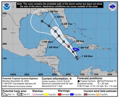
As of the NHC’s 7 a.m. advisory, what is now called Potential Tropical Cyclone Eighteen was located about 220 miles south of Kingston, Jamaica and 425 miles southeast of Grand Cayman moving north at 7 mph with maximum sustained winds of 35 mph.
A hurricane warning is in effect for the Cayman Islands and tropical storm warning in place for Jamaica.
“On the forecast track, the system is expected to move near Jamaica this evening, be near or over the Cayman Islands on Tuesday,and approach Cuba on Wednesday,” forecasters said. “The disturbance is expected to become a tropical depression or stormtoday with additional strengthening forecast thereafter. The system could be near or at hurricane intensity when it passes near theCayman Islands and Cuba.”
Rainfall totals could reach more than 9 inches over Jamaica and Cuba through mid-week, and then spread north into Florida and adjacent areas of the southeast United States in the latter half of the week.
Forecast models have shifted more to the west since the weekend with the center of the storm entering the Gulf of Mexico still as a Category 1 hurricane, but losing steam before landfall likely along the Texas or Louisiana coast, although the western Florida panhandle remains within the cone of uncertainty.
“Over the next few days, the system should move generally northwestward on the southwestern periphery of a mid-level high pressure system near and east of the Florida peninsula,” forecasters said. “Later in the forecast period, the track guidance diverges significantly.”
The National Weather Service in Miami forecasts more than 2 inches of rain on Tuesday for parts of South Florida with windy conditions. The NWS in Melbourne said 1-2 inches are likely later Tuesday for Central Florida.
Because the system has yet to form a well-defined center, this is more uncertainty in the forecast track.
“Interests in Cuba and the Florida Keys should closely monitor this system as hurricane and tropical storm watches could be required for portions of these areas later today,” forecasters said. “The system is forecast to enter the western Gulf of Mexico later this week, but given significant uncertainties in the long-range forecast track and intensity, it is too soon to determine what, if any, impacts could occur.”
The NHC also continued to track a potential system that could form north of the Caribbean’s Leeward Islands in a few days.
“Some slow development of this system is possible after that time as it moves generally westward over the southwestern Atlantic,” forecasters said.
The NHC gives it a 20% chance to develop in the next seven days.
And what had developed into Tropical Storm Patty is quickly losing its tropical characteristics as it speeds toward Spain in the far eastern Atlantic.
As of the NHC’s 4 a.m. advisory, the center of Patty was located about 490 miles east of the Azores moving east-northeast at 20 mph with maximum sustained winds of 40 mph.
The system has tropical-storm-force winds extending out 80 miles from its center, but it projected to weaken into a post-tropical cyclone later Monday.
Its remnants will still bring significant rainfall to parts of the Iberian peninsula with up to 5 inches in portions of Portugal and western Spain.
The 2024 Atlantic hurricane season has produced 16 named storms so far including 10 hurricanes, three of which have struck Florida’s Gulf Coast.
Rafael would be the 17th with the official hurricane season running through Nov. 30.
___
©2024 Orlando Sentinel. Visit at orlandosentinel.com. Distributed by Tribune Content Agency, LLC.


Comments