Hurricane Milton makes landfall; will it hit Orlando?
Published in News & Features
ORLANDO, Fla. — Hurricane Milton made landfall as a major Category 3 hurricane Wednesday night on Siesta Key west of Sarasota with a projected path that will bring it across Central Florida south of Orlando and out through Brevard County.
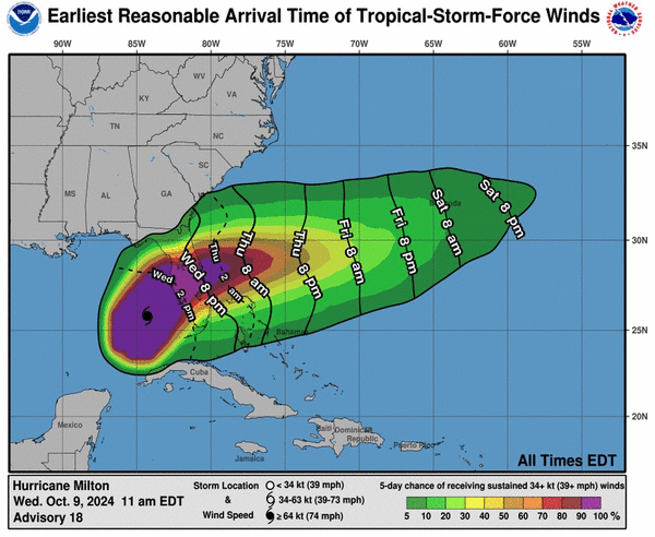
As of the special 8:30 p.m. Eastern time advisory, the center of Milton was located about 5 miles west of Sarasota and 115 miles southwest of Orlando moving east-northeast at 15 mph with maximum sustained winds of 120 mph.
Hurricane-force winds extend out 35 miles and tropical-storm-force winds extend out 255 miles from its center.
The latest forecast track from 5 p.m. has the storm passing closer to Orlando across Polk County near Leesburg as a Category 1 hurricane with 85 mph sustained winds and 105 mph gusts before heading through Poinciana south of Kissimmee and then toward central Brevard County near Cape Canaveral never losing hurricane status as it crosses the state into the Atlantic.
“Milton’s wind field is expected to grow considerably in size while it moves across Florida,” forecasters said. “Additionally, a large region of tropical storm and hurricane-force winds could occur on the northwest/back side of the storm since Milton will be interacting with a frontal boundary and beginning extratropical transition.”
The National Weather Service in Melbourne has all of inland Central Florida under a hurricane warning as well as flood watches. Storm surge warning is in place on the east coast of Florida from Sebastian Inlet up into Georgia.
“Residents and visitors should prepare for hurricane force winds, especially in gusts, widespread flooding impacts with flash and river flooding likely near to north of the center where Milton tracks, a few tornadoes, and battering surf and storm surge along portions of the coast,” said NWS meteorologist Tim Sedlock. “Conditions will deteriorate through tonight and linger through Thursday into Thursday night.”
Rain forecasts have now increased with the NHC predicting some areas getting as much as 15 inches on its path.
Sedlock said 6-12 inches can be expected near north of Orlando down to Melbourne with 3-6 inches farther south.
“Rain intensity will quickly diminish Thursday night as Milton moves off of the east Florida coast and departs the area,” Sedlock said. “With heaviest rainfall generally forecast across northern portions of east central Florida this may lead to considerable flooding impacts along the St. John`s River, with flash flooding likely, especially across the urban I-4 corridor.”
A flood warning is already in effect for the St. Johns River near Astor affecting Volusia and Lake counties.
“Hurricane preparations should be rushed to completion no later than this morning,” Sedlock said Wednesday. “Flooding rainfall and isolated tornado impacts from Milton could begin as early as this morning!”
Another issue from the forecast track will be battered coasts along Brevard and Volusia counties. Hurricane Ian causes severe erosion, heavy surf and coastal flooding especially in Volusia when it hit in a similar manner crossing from west to east.
The Space Force’s Space Launch Delta 45 late Saturday put Cape Canaveral Space Force Station and Patrick Space Force Base under HURCON 2 predicting surface winds in excess of 58 mph within 24 hours.
“Forecasts show Milton is expected to be a Category 1 hurricane when it arrives in our area,” said SLD 45 public affairs media chief Emre Kelly. “While the anticipated impacts of this storm are not driving a mandatory evacuation, we do expect downed trees, power outages, possible cell service outages, and localized flooding. Evacuation of nonessential personnel and families is voluntary.”
The U.S. Coast Guard has set Port Canaveral’s port condition to “ZULU,” meaning sustained gale-force winds are expected within 12 hours. Vessel movement has stopped, but landside fuel operations continue. Jetty Park is closed until further notice.
The state suspended all tolls in west Florida, Central Florida and Alligator Alley as of 10:30 a.m. Monday for seven days.
Disney, Universal, SeaWorld, Legoland and Kennedy Space Center Visitor Complex were among all the theme parks and attractions that will be closed Wednesday and Thursday.
In Central Florida, UCF and Valencia State College canceled classes Tuesday through Thursday while Rollins canceled classes for the whole week. Lake, Osceola, Orange and Volusia counties announced no canceled classes Wednesday, some on Thursday already, and some with shortened hours or limited after-school activities Tuesday.
SunRail announced it would shut down beginning Tuesday and remain closed through at least Thursday depending on the storm impact.
Commercial operations at both Orlando International Airport and Orlando Executive Airport will cease beginning Wednesday morning, although both airports will remain open for emergency use. Orlando Sanford International Airport also announced Tuesday it would cease operations Wednesday. Daytona Beach International Airport shut down Wednesday morning and Melbourne International Airport closed Wednesday afternoon and was scheduled to reopen Friday.
______
©2024 Orlando Sentinel. Visit at orlandosentinel.com. Distributed by Tribune Content Agency, LLC.


Comments