What Philly's growing dry spell has to do with Hurricanes Milton and Helene
Published in News & Features
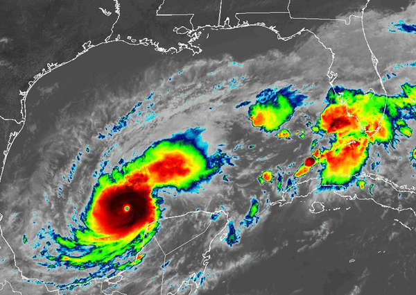
With the Gulf of Mexico on simmer, for the people on Florida’s West Coast the reality horror show that is an approaching hurricane is forecast to reach a climax Wednesday night somewhere near the heavily developed Tampa Bay region, with potentially catastrophic results.
This, less than two weeks after much of the Sunshine State was soaked by downpours from Helene that went on to deluge the South from Tallahassee to Charlottesville, Va. Rainfall amounts exceeded 20 inches in some areas, raising fresh concerns about the role of worldwide warming.
By contrast, Philadelphia’s city-wide rainfall in the last 30 days — 0.34 inches — has been about 8% of normal, according to the Middle Atlantic River Forecast Center. The interagency U.S. Drought Monitor has a significant portion of the region, including all of Chester County and most of the state of Delaware, in “moderate drought.” Dry conditions could stretch into November, says AccuWeather Inc. long-range forecaster Paul Pastelok.
And the fact that October is producing a harvest of dust around here evidently has something to do with Helene and Milton and what’s been happening to our south.
The Gulf is primed to produce moisture, but it’s not getting to Philly
Lacking summer thunderstorms and the more-organized storms characteristic of late fall, rains associated with moisture-bearing tropical-storm remnants are important sources of precipitation in the Philadelphia region in September and October.
“You have to rely a lot of times on tropical systems getting this far north,” said Tom Kines, an AccuWeather senior meteorologist. “It’s not happening.”
These days, that prime precipitation supplier — the Gulf of Mexico — in brimming with moisture-laden air. Sea-surface temperatures are running as high as 5 degrees Fahrenheit above normal, NOAA says.
But the pattern hasn’t favored exporting rain to the Northeast, said Kines, and Helene and Milton, as it prowls the Gulf, have been significant factors lately.
“Those systems robbed the moisture,” he said.
Helene-devastated Asheville, N.C. — home of the government’s national climate center, which effectively has been shut down — measured 17.9 inches of rain in September. Areas to the east experienced over 20 inches, with double-digit rain totals as far north as Charlottesville, according to the Southeast Regional Climate Center.
But the rains have been reaching a dry wall somewhere near the Mason-Dixon line. Philly finished September with 0.77 inches of rain officially at Philadelphia International Airport, the eighth driest on record, and still awaits the first drop of October.
Meanwhile, since Sept. 1, Tampa has had over 15 inches of rain, more than double its normal total, with the National Hurricane Center calling for 12 to 16 inches more from Milton.
Will Milton remain a “major” hurricane when it reaches the Florida coast?
On Tuesday afternoon, the center of Milton, with peak winds of 155 mph, was about 500 miles southwest of Tampa.
It was uncertain how much strength it would maintain and whether it would make landfall as a “major” hurricane, those with peak winds of at least 111 mph.
Milton may weaken as it encounters storm-battling wind shear, said Philip Klotzbach, hurricane expert at Colorado State University, but it may rally when it encounters a Gulf “loop current,” an especially warm swathe of water.
“The Gulf of Mexico is just so much warmer than normal right now,” he said. “There is tons of fuel there.”
Typically, hurricanes stir up warm surface water and allow colder, below surface waters to rise.
But, said Lew Gramer, a NOAA physical oceanographer, Milton “continues to draw energy from that warm surface water, and simply cannot mix the ocean deep enough to begin to cool the surface.” Cool waters would dilute Milton’s power.
Will any of Milton’s rains reach the Jersey Shore or the Philly region?
After it buzzsaws through Florida, Milton is forecast to weaken and sail into the North Atlantic, the center passing near or south of Bermuda.
“I don’t think there’s any way Milton’s moisture” gets anywhere near the Philly area, said Kines.
When is Philadelphia’s next chance at significant rain?
At this point, should the Phillies make it to the next round of playoffs and to the World Series, it’s unlikely that rain at Citizens Bank Park would be an issue.
The Climate Prediction Center outlook through Oct. 22 sees the odds continuing to favor below-normal precipitation.
While a likely disaster unfolds in Florida, the next several days in the Philly region are forecast to be full of that oblique October sunlight with daytime temperatures in the 60s and 70s.
_____
©2024 The Philadelphia Inquirer. Visit inquirer.com. Distributed by Tribune Content Agency, LLC.


Comments