Current News
/ArcaMax

Trump signals willingness to lower China tariffs 'at some point'
President Donald Trump said he is willing to lower tariffs on China at some point because the levies now are so high that the world’s two largest economies have essentially stopped doing business with each other.
Trump has placed tariffs as high as 145% on Chinese imports. China has retaliated with tariffs of 125% on American imports. The ...Read more

NY Sens. Schumer, Gillibrand call for GOP lawmakers to step up after Trump layoffs threaten 9/11 health program
The Trump Administration’s funding shell game over the health program that treats 9/11 first responders with Ground Zero-related illnesses continued this weekend with a fresh round of layoffs — and New York’s Senate delegation is calling on their Republican colleagues to step up and save the program.
Friday’s mass layoffs at the ...Read more

1 person killed, at least 13 wounded in shooting at Houston party
One person was killed and at least 13 more wounded in a mass shooting at a family barbecue in Houston early Sunday morning, police said.
None of the victims has been publicly identified, and officials said Sunday they did not know the ages of all the victims.
Cops detained multiple people at the scene on Houston’s southeast side, but ...Read more

Survey: Georgia OB-GYNs say state abortion law risks mothers' health
A survey of 38 of Georgia’s OB-GYNs found that nearly half of doctors participating said they have personally encountered cases where care had to be delayed, causing death or health complications for the mother, as a result of ambiguity in the state’s abortion law.
The survey, done by the American College of Obstetrics and Gynecology in ...Read more

Czechs lead talks on ammunition supplies for Ukraine into 2026
Czechs are leading talks on continuing deliveries of heavy ammunition for Ukraine stretching into 2026, said President Petr Pavel.
The Czech leader, speaking after meeting Ukrainian President Volodymyr Zelenskyy in Prague on Sunday, said the so-called Czech ammunition initiative financed by 11 countries was on track to deliver 1.8 million ...Read more

Israel prepares to scale up pressure on Gaza ahead of Trump visit
Israel’s security cabinet was set to meet on Sunday to approve an expansion of military action in Gaza and discuss aid deliveries ahead of a planned visit to the Middle East this month by President Donald Trump.
The new ground operations will likely involve taking control of additional territory while stopping short of a full siege, ...Read more
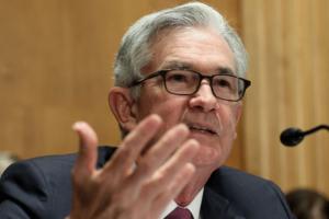
Trump rules out firing Powell while pushing him to cut rates
President Donald Trump insisted he doesn’t plan to fire Federal Reserve Chair Jerome Powell despite his sustained criticism over the pace of interest rate cuts.
“Why would I do that?” he said in an interview on NBC’s "Meet the Press" with Kristen Welker that aired Sunday. “I get to replace the person in another short period of time.�...Read more

Dog data may help track dangerous disease for humans
SAN JOSE, Calif. — For man’s best friend, pet owners often go to great lengths – whether that’s doggy day care and specialty pup chow, or late nights at the vet running tests that drain bank accounts.
Now, a new study by researchers from UC Davis and UC Berkeley has found a way our canine companions can help us, offering a unique ...Read more

Women from Bay Area are leading the nation in delaying motherhood
LOS ANGELES — When it comes to delaying motherhood to pursue careers and other life aspirations, Bay Area women are leading the nation.
This region is home to the greatest share of women having children at 40 and older — a trend that experts chalk up to a combination of economic opportunity, progressive social norms and access to ...Read more
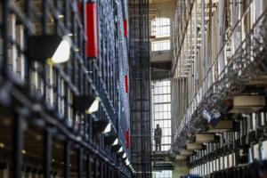
Thousands of California prisoners falsely tested positive for opioids. Did it cost them their freedom?
Thousands of inmates wrongly tested positive for opiate use inside California state prisons last year because of a laboratory mistake, and civil rights attorneys now worry many of them could be denied parole and a chance at freedom because of it.
About 6,000 drug tests are believed to have generated false positive results in 2024, according to ...Read more

Preventing homelessness: the tough job of predicting who is at real risk
LOS ANGELES -- When the unknown number popped up on her phone, Jocelyn Escanuela was in the checkout line at Walmart. She still can't explain why she picked up and then listened to a cold-caller's pitch that sounded a lot like a scam.
She had been selected to receive a grant of $6,000, the caller told her. And she would have a personal ...Read more

Elon Musk wins vote to establish his own city in Starbase, Texas
Voters in South Texas delivered Elon Musk a decisive victory, overwhelmingly approving a ballot measure to establish Starbase, Texas, as its own city.
By a margin of 173 to 4, residents of the far-flung community surrounding SpaceX’s rocket-launch site and headquarters voted resoundingly in favor of the incorporation effort, according to ...Read more

Colorado House passes immigrant protection bill amid new Trump lawsuit against state
A day after the Trump administration sued Denver and Colorado officials to invalidate restrictions on cooperation with immigration enforcement, Democratic lawmakers gave final approval Saturday to a bill that would expand the state’s laws.
As the end of the 2025 legislation approaches, the state House’s 42-21 party-line vote approving ...Read more

Two men in ICE custody died of 'natural' causes. Were their deaths preventable?
He survived Russia’s invasion of Ukraine, evacuated women and children in Kyiv to safety, and then crossed the border to escape the war.
But after he arrived at the Krome North Service Processing Center in southwest Miami-Dade County, Maksym Chernyak, 44, suffered a stroke. Staff took more than 40 minutes to call 911. Later that day, on Feb. ...Read more

Vietnam protests China, Philippines activity in disputed waters
Vietnam lodged a formal protest against China and the Philippines for activities that it said violate its sovereignty in the Spratly Islands area, in a move that underscores the persistent tensions over contested waters in the South China Sea.
Vietnam requires relevant parties to “refrain from actions that complicate the situation” and to ...Read more

South Korea's ruling party picks ex-minister as presidential nominee
South Korea’s ruling party has selected former labor minister Kim Moon-soo as its presidential candidate to take on opposition nominee Lee Jae-myung, who is leading opinion polls ahead of next month’s election.
The race to become the People Power Party’s candidate had narrowed down to Kim and former PPP leader Han Dong-hoon. Ex-acting ...Read more

Art Institute of Chicago president reportedly stripped on plane, faces independent probe
CHICAGO — The president and director of the Art Institute of Chicago faces an independent investigation amid a report that he stripped on a commercial airplane.
James Rondeau is voluntarily taking time away from his office while the investigation is completed, an Art Institute spokesperson said in a statement. “The Art Institute takes this ...Read more

LA federal prosecutors resign over plea deal for convicted sheriff's deputy, sources say
LOS ANGELES — Several federal prosecutors — including the chief of the Public Corruption and Civil Rights Section — have submitted their resignations following a plea deal offered by the new U.S. attorney in Los Angeles to a sheriff’s deputy who had already been found guilty of using excessive force.
Two sources confirmed to The Times ...Read more
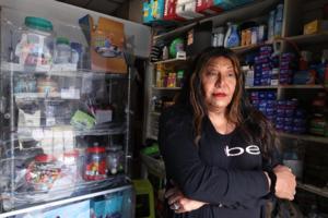
String of unsolved 'transphobic' attacks target MacArthur Park shopkeeper
LOS ANGELES — At her hole-in-the-wall convenience store across the street from MacArthur Park, Sabrina de la Peña has supplied cold beverages, household necessities and kind words for nearly 30 years.
Despite issues with crime in the area, De la Peña, 61, said she never felt threatened by a customer until last month. Over the course of two ...Read more

Fired federal prosecutor claims ex-Fatburger CEO's 'smears' reached White House
LOS ANGELES — A former burger chain CEO under federal indictment on gun and fraud charges now faces another accusation: Allegedly spreading "smears" that reached the White House through conservative pundits, leading to the prosecutor who was handling his case getting fired.
The latest claim was leveled by Adam Schleifer, formerly an assistant...Read more
Popular Stories
- Trump sparks backlash dressed as pope in AI image shared by White House
- After disasters, FEMA leases apartments for survivors. But not after the LA fires
- 'Just bodies of animals everywhere': Toxic algae bloom taking a toll on Southern California's marine life
- Two men in ICE custody died of 'natural' causes. Were their deaths preventable?
- Elon Musk wins vote to establish his own city in Starbase, Texas
Comics