Milton now a Category 1 hurricane. Florida Gulf Coast preps for massive evacuations
Published in News & Features
Florida’s west coast is preparing for a potentially massive evacuation ahead of a strike from Milton, which rapidly intensified into a Category 1 hurricane on Sunday afternoon.
The Gulf coast, still reeling from massive coastal flooding from Helene — Tampa Bay’s worst hurricane in a century — remained in the crosshairs of Milton, a small but fast-strengthening storm expected to become a major Category 3 or even 4 hurricane before it bulldozes the Gulf Coast.
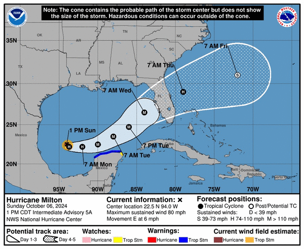
At 5 p.m. Sunday, the center of the National Hurricane Center’s forecast track went through Sarasota and cut across the state south of Orlando. It’s a southern bump in the track compared to earlier in the morning, with more shifts — potentially back north or farther south — expected over the next few days.
Nearby communities were already swamped by record storm surge from the passage of Helene just over a week ago. Milton, on its current track, could potentially bring much worse. The Category 1 hurricane, packing winds of 85 mph Sunday evening, was expected to quickly strengthen into a major hurricane over the hot waters of the Gulf of Mexico.
The latest forecast calls for Milton to hit Category 4 over the open waters of the Gulf before slowing down to a Category 3 with a much broader footprint ahead of landfall, potentially spreading storm surge and high winds over a much bigger area. Landfall is expected sometime Wednesday evening to early Thursday.
“I’d urge Floridians to take this storm very seriously. Do not get wedded to the cone,” Gov. Ron DeSantis said in a Sunday morning press conference. “Anybody on the west coast of Florida … you have the potential for major impacts.”
The NHC dispatched Hurricane Hunter planes into Milton and could begin posting hurricane and storm surge watches as early as Sunday evening. Some counties began calling for mandatory evacuation orders on Sunday. In Manatee County, mandatory evacuation orders begin Monday at 2 p.m., and Pinellas called for its first wave of mandatory evacuations — people in long-term residential health care facilities in Zone A.
Kevin Guthrie, head of Florida’s Department of Emergency Management, urged Floridians to prepare to leave if asked to do so by local officials, ahead of potentially “life-threatening” amounts of storm surge.
“We are preparing for the largest evacuation we have seen since, most likely, 2017 Hurricane Irma,” he said.
DeSantis declared a state of emergency in 51 counties, including Miami-Dade and Broward, and directed state agencies to help expedite the cleanup in counties that still have piles of debris from Helene on their roads. The state sent high water rescue vehicles to coastal western counties and is busy wrapping fire stations, hospitals and sewage plants with hundreds of feet of flood protection dams.
The governor warned that, although nearly all power has been restored in the two weeks since Helene hit, this storm could bring even more outages deeper inland.
“If we do have an I-4 storm, we’re going to have a lot of power outages. That’s something people should be prepared for,” he said. “This is not a good track for the state of Florida.”
Widespread flooding likely
For South Florida, the impact will depend on Milton’s path. Miami-Dade, Broward and Monroe counties remain out of the NHC’s “cone of concern” early Sunday but that could change. At the very least, heavy rains could drench much of the region, starting Wednesday.
Much of the region was already under flash flood warnings with eight inches or more of rain possible in some areas from a separate system that is expected to cause street — and possibly home — flooding. If Milton’s path shifts south, tropical storm-force winds could sweep the area as well.
Just before landfall, forecasters predict Milton could be a Category 3 hurricane with 120 mph sustained winds moving at a pretty fast clip, 15 mph. That pace could help it hold onto its strength as it crosses the peninsula. The forecast calls for Milton to still be a category 1 hurricane by the time it emerges on Florida’s east coast, likely south of Daytona Beach.
That size and speed make storm surge a real threat to the West Coast — again.
On its latest track, Milton could bring more than 10 feet of storm surge to the inside of Tampa Bay and to Bradenton and Longboat Key to the south, according to a visualization from Louisiana State University’s storm surge model.
“Bottom line is, you’re potentially looking at storm surge that is more significant than what we saw with Hurricane Helene,” DeSantis said Sunday morning.
The hurricane center has not released official projections for how much storm surge the region might see, but it’s clear the numbers will be high near and to the south of landfall.
Milton continued to grow stronger on Sunday as it rapidly intensified into a hurricane. The latest projections call for the storm to hit Category 4 in the open Gulf of Mexico before weakening slightly to a Category 3 as it approaches Florida’s west coast.
“Intensity guidance is about as bullish as I’ve seen in this part of the basin, with almost everything showing a peak intensity of category 4 or 5 in the southern Gulf of Mexico in a day or two,” NHC forecaster Eric Blake wrote in the Sunday 5 p.m. update. “The regional hurricane models are showing the system growing even if it weakens, and we are expecting Milton to be a large hurricane at landfall, with very dangerous impacts spread out over a big area.”
A weaker storm may mean slightly lessened wind impacts, but a weaker storm is also a broader storm. That could send heavy rains and high storm surges over a wide area, similar to how Hurricane Helene’s effects could be felt hundreds of miles from the eye.
The same factors that could cause Milton to grow could also determine when and where Milton makes the turn to the northeast, which is expected on Tuesday. Craig Setzer, chief meteorologist for Royal Caribbean Group, said he’s watching it very closely.
“If the turn is delayed, then Milton could end up coming ashore well south of Tampa. However, if the turn is earlier, then it could come in north of Tampa,” he wrote on Twitter. “Either way, Tampa remains in the middle of the threat, and more importantly, we can’t wait until Tuesday to start preps, they need to be started now.”
“That’s the issue with hurricane preps, we often must prepare over a larger area well before we know for sure exactly who will get hit the hardest.”
_____
©2024 Miami Herald. Visit miamiherald.com. Distributed by Tribune Content Agency, LLC.


Comments