NHC expects major Hurricane Milton to strike Florida on Wednesday
Published in News & Features
ORLANDO, Fla. — The National Hurricane Center warned Saturday that newly formed Tropical Storm Milton will intensify into a major hurricane before it hits Florida on Wednesday.
“Milton is within favorable atmospheric and oceanic conditions for strengthening,” said NHC Branch Chief Daniel Brown. “With the expected low vertical wind shear conditions, steady to rapid strengthening appears likely during the next few days.”
As of the NHC’s 5 p.m. advisory, Tropical Storm Milton had sustained winds of 40 mph as it moved north-northeast at 3 mph, located about 245 miles north of Veracruz, Mexico, and 385 miles west-northwest of Progresso, Mexico. Tropical-storm-force winds extend out 35 miles.
Brown said it’s forecast to become a hurricane by Sunday, and a major hurricane by Monday afternoon with 115 mph sustained winds and gusts of 140 mph, an intensity expected to hold before landfall somewhere on Florida’s Gulf Coast by Wednesday afternoon.
It could become stronger, Brown warned.
“The regional hurricane models continue to be quite aggressive in intensifying Milton,” he said. “Upward adjustments could be required if the dynamical hurricane models continue their trends. Regardless of the exact details of the intensity forecast, an intense hurricane with multiple life-threatening hazards is likely to affect the west coast of the Florida Peninsula next week.”
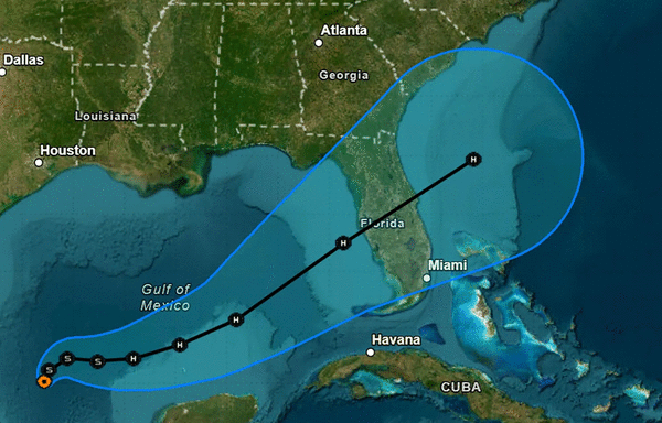
The five-day cone of uncertainty ranges from the south near Naples all the way up to the Big Bend, though, with the forecast center for now slightly farther north with a potential landfall near Tampa Bay and a track across Orlando and Central Florida out through the Space Coast into the Atlantic.
“The updated official forecast is slightly north of the previous track and is a little slower to be in better agreement with the latest multi-model consensus aids,” Brown said. “Users are again reminded to not focus on the exact forecast track or timing at the longer range as the average NHC 4-day track error is about 150 miles.”
Gov. Ron DeSantis declared a state of emergency for 35 counties ahead of the storm including Brevard, Broward, Charlotte, Citrus, Collier, DeSoto, Flagler, Glades, Hardee, Hendry, Hernando, Highlands, Hillsborough, Indian River, Lake, Lee, Manatee, Marion, Martin, Miami-Dade, Monroe, Okeechobee, Orange, Osceola, Palm Beach, Pasco, Pinellas, Polk, Putnam, Sarasota, Seminole, St. Johns, St. Lucie, Sumter, and Volusia counties.
The NHC upgraded what had been Tropical Depression Fourteen to Tropical Storm Milton in a special 1:25 p.m. advisory.
The NHC warned the system could affect the Yucatan Peninsula of Mexico before threatening the Florida Peninsula, Florida Keys and the northwestern Bahamas, and hurricane and storm surge watches could be required for portions of Florida on Sunday.
The system will continue to move slowly to the northeast or east-northeast for the next day, the NHC stated.
“A slightly faster eastward to east-northeastward motion is forecast by Monday and Tuesday,” Brown said. “On the forecast track, the system is forecast to remain over the southwestern Gulf of Mexico through Sunday night, then move across the south-central Gulf of Mexico on Monday and Tuesday, and approach the west coast of the Florida Peninsula by midweek.”
Impacts on Florida will include storm surge and heavy rains with up to 12 inches forecast for portions of the Florida Peninsula and Florida Keys through Wednesday night.
“This rainfall brings the risk of flash, urban, and areal flooding, along with minor to isolated moderate river flooding,” Brown said.
Tampa Bay and the rest of the Gulf Coast of the state just endured major storm surge and wind damage from Hurricane Helene only 10 days ago.
“There is an increasing risk of life-threatening storm surge and wind impacts for portions of the west coast of the Florida Peninsula beginning late Tuesday or Wednesday,” Brown said. “Residents in these areas should ensure they have their hurricane plan in place, follow any advice given by local officials, and check back for updates to the forecast.”
Much of the state including all of central Florida remains under a flood watch from Sunday though Thursday, according to the National Weather Service.
“Excessive runoff may result in flooding of rivers, creeks, streams, and other low-lying and flood-prone locations,” the NWS advisory states. “Flooding may occur in poor drainage and urban areas.”
In addition, swells generated by the system will begin to hit the southwestern Gulf of Mexico coast today, spreading to the north and east by early next week.
The National Weather Service in Melbourne said the rain associated with the system will worsen rainfall expected to already have saturated the area because of a stalled front that’s coming down from North Florida on Sunday.
“This feature may help boost rainfall totals across the Lake Okeechobee and Treasure Coast region, perhaps even as far north as Orlando and the Space Coast,” said said NWS meteorologist Brendan Schaper. “As a result, a marginal risk for excessive rainfall is in place areawide with a slight risk concentrated from Orange and Brevard County southward along the Treasure Coast.”
He said areas could see 1-2 inches on the eastern half of central Florida with some areas getting more than 4 inches, especially near the barrier islands.
“If similar locations see appreciable rain Sunday and again on Monday, the threat for flooding will only tend to increase,” he said.
The NHC also is keeping track of two hurricanes in the Atlantic.
As of 5 p.m., Hurricane Kirk was located about 1,140 miles northeast of the northern Leeward Islands and 1,435 miles west-southwest of the Azores moving north at 20 mph with sustained winds of 120 mph.
That keeps Kirk a major Category 3 hurricane, but it has lost steam since it reached Category 4 level earlier this week.
“A faster northeastward motion is expected on Sunday and Monday,” forecasters said Saturday. “Weakening is forecast through early next week, but Kirk will remain a large hurricane for the next couple of days.”
Hurricane-force winds extend out up to 60 miles and tropical-storm-force winds extend out up to 230 miles from its center.
The NHC warns those in the Azores to keep track of the storm while its long-range forecast has it approaching Europe as a subtropical storm by early Wednesday.
Despite its distance across the Atlantic, swells from Kirk are expected to hit the east coast of Florida and elsewhere this weekend bringing life-threatening surf and rip current conditions.
As of 5 p.m. Hurricane Leslie, which became the eighth hurricane of the season late Friday, was located about 810 miles west-southwest of the southernmost Cape Verde Islands moving west-northwest at 8 mph with maximum sustained winds of 80 mph, which makes it a Category 1 hurricane.
“A northwestward motion with an increase in forward speed is forecast to begin by tonight and continue through Tuesday,” forecasters said. “A gradual weakening trend is forecast to begin on Sunday.”
Hurricane-force winds extend out up to 15 miles and tropical-storm-force winds extend out up to 105 miles from its center.
The NHC also has its eyes on a tropical wave expected to move off the west coast of Africa early next week.
“Some development of this system is possible thereafter while it moves westward or west-northwestward across the eastern tropical Atlantic,” forecasters said. “The system is expected to move near or over the Cabo Verde Islands on Wednesday and Thursday, and interests there should monitor its progress.”
The NHC gives it a 30% chance to develop in the next seven days.
The 2024 Atlantic hurricane season has had 13 named storms including eight hurricanes, three of which grew to major hurricane strength and now five tropical storms. There was also one potential tropical cyclone that didn’t develop before landfall that prompted NHC advisories, and why the latest depression took the number “14” before growing into Tropical Storm Milton.
Colorado State University meteorologist Philip Klotzbach said that puts the season slightly above average across several categories, although the season has seen less total number of days with any named storm than normal.
The development of Leslie into a hurricane, though, marked a major surge in hurricane formation with only nine-and-a-half days between Hurricane Helene and the three more to follow it — Isaac, Kirk and now Leslie. Four hurricanes had not formed that quickly since 2012, he said.
Hurricane season runs from June 1 to Nov. 30.
©2024 Orlando Sentinel. Visit orlandosentinel.com. Distributed by Tribune Content Agency, LLC.


Comments