Hurricane center gives high odds Gulf of Mexico system headed to Florida will develop
Published in News & Features
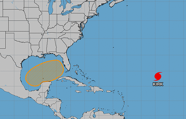
ORLANDO, Fla. — Odds are now high that a system developing in the Gulf of Mexico could become a tropical depression or storm before it makes its way to Florida next week, according to the National Hurricane Center.
As of the NHC’s 8 p.m. Eastern time tropical outlook, forecasters are looking at a broad area of low pressure in the southwestern Gulf of Mexico with disorganized showers and thunderstorms.
“Gradual development of this system is expected, and a tropical or subtropical depression or storm is likely to form late this weekend or early next week while the system moves eastward or northeastward across the Gulf of Mexico,” forecasters said. “Interests in the Florida Peninsula and the Florida Keys should monitor the progress of this system.”
If it becomes powerful enough, it could form into Tropical Storm Milton.
Whether is develops into a named system or not, the NHC warns heavy local rains could occur over both portions of Mexico over the weekend and over much of Florida from late Sunday through the middle of next week.
The NHC gives it a 30% chance to develop in the next two days and 70% chance in the next seven days, up significantly from Thursday projections.
The National Weather Service in Melbourne concurs rains with the potential for flooding could threaten Florida starting Sunday and running through midweek.
“Models indicate a stationary boundary will set up somewhere across the central or southern Florida Peninsula and stay in place until later Wednesday or Thursday before drifting farther south,” said NWS meteorologist Brendan Schaper. “At least one or two disturbances are expected to ride along the front, crossing the state of Florida and bringing the chance for repeated rounds of heavy rainfall to the area.”
He said some models bring the potential tropical system across South Florida by midweek.
“Whether a low pressure system takes on tropical characteristics or not, it is clear that heavy rain and flooding potential will be increasing as the week wears on,” he said. “Exact locations and amounts are to be determined, though the southern half of east Central Florida will be likely be favored for higher rain totals.”
That area has been deemed at marginal risk for excessive rainfall Monday and Tuesday, according to the NWS Weather Prediction Center.
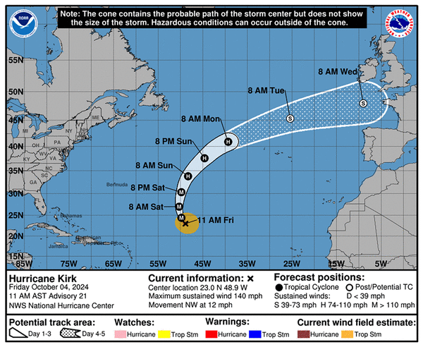
The state’s east coast is also subject to heavy surf from distant Category 4 major Hurricane Kirk in the Atlantic.
“A high risk of rip currents also exists at the beaches today, likely lasting into the weekend and next week, as persistent east-northeast winds create increasingly rough surf. Entering the surf is strongly discouraged,” he said.
The NHC continued to track Hurricane Kirk and Tropical Storm Leslie in the Atlantic.
As of 5 p.m., Kirk was located about 960 miles east-northeast of the northern Leeward Islands and 1,645 miles west-southwest of the Azores moving northwest at 12 mph. Maximum sustained winds increased to 130 mph, making it a Category 4 storm and the season’s third major hurricane.
Hurricane-force winds extend out up to 35 miles and tropical-storm-force winds extend out up to 220 miles from its center.
“A turn toward the north and northeast at a faster forward speed is anticipated over the weekend,” forecasters said Friday. “Kirk is a Category 4 hurricane on the Saffir-Simpson Hurricane Wind Scale. Small intensity fluctuations are possible today and tonight. Weakening is forecast to begin on Saturday and continue through early next week.”
The NHC said the Azores should monitor progress of the storm, and its long-term forecast has it coming close to Europe by Tuesday night as a subtropical storm.
As of 5 p.m., Leslie was located about 695 miles west-southwest of the southernmost Cape Verde Islands moving west-northwest at 7 mph with maximum sustained winds of 70 mph. Tropical-storm-force winds extend out up to 70 miles from its center.
“A turn toward the northwest and an increase in forward speed is expected early Sunday into Monday,” forecasters said on Friday. “Additional strengthening is forecast, and Leslie is expected to become a hurricane tonight or Saturday.”
The NHC also on Friday began to forecast development for a tropical wave expected to move west from the coast of Africa on Monday or Tuesday.
“Some development of this system is possible thereafter as it moves westward or west-northwestward across the eastern tropical Atlantic,” forecasters said.
The NHC warned those in the Cape Verde Islands should keep track.
The NHC gives it a 30% chance to develop in the next seven days.
The season so far has 12 named storms including seven hurricanes and five tropical storms. The season runs from June 1-Nov. 30.
©2024 Orlando Sentinel. Visit at orlandosentinel.com. Distributed by Tribune Content Agency, LLC.


Comments