Days of torrential rain -- or even a tropical system -- are on tap for Florida
Published in News & Features
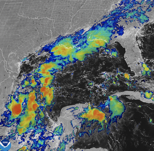
A complex weather system is blooming in the Gulf of Mexico, putting much of Florida in the path of a days-long rain storm starting late in the weekend and possibly spawning a tropical system that could impact the state by the middle of next week.
As of Friday morning, the National Hurricane Center increased the odds to 40% that a tropical depression or storm will form in the Gulf. Whatever develops is forecast to move gradually west to east toward Florida.
And regardless of development, the weather system will be very wet, widespread and enduring for several days, forecasters said.
“Whatever shape the system takes, an extended period of rain is likely for the Florida Peninsula,” meteorologist Bryan Norcross wrote on his blog, Hurricane Intel, on Friday morning. “On the current schedule, rain chances increase by Sunday, especially south of I-4, and continue through much of the week. The front will eventually push down the state, clearing North and Central Florida first, but a wet weather pattern could well continue in South Florida.”
The weather pattern is complex, consisting of three waves: the remnants of a tropical Pacific system moving east over southern Mexico and Central America, a wave in the western Caribbean Sea off the Yucatan Peninsula, and a building low-pressure system in the Bay of Campeche west of the Yucatan.
“The three separate systems are forecast to merge over the weekend into a single large disturbance stretched out over the Gulf of Mexico,” Norcross wrote. “The system will be broad and disorganized but will hold a lot of moisture.”
A tropical or subtropical depression or storm could form during the early to middle part of next week, the hurricane center said, particularly because both surface and deep-water temperatures in the Gulf are still very warm.
Forecasters warned that the complex pattern means the predictions are very uncertain and residents along the U.S. Gulf coast, especially in Florida, should watch the forecast closely.
“While the exact track and intensity of the (system) unfolding in the Gulf have yet to be determined, Florida will bear the brunt this time around,” AccuWeather Chief On-Air Meteorologist Bernie Rayno said. “At this time, the intensity will range from a sprawling tropical rainstorm to perhaps a strike from a more compact, full-blown hurricane.”
The system is carrying a lot of moisture, bringing heavy rainfall to parts of the Florida already saturated by Hurricane Helene. As much as a foot of rain could fall in some areas, Norcross wrote in his post.
Elsewhere, the tropics remain active with a hurricane and a tropical storm in the eastern Atlantic, with both Hurricane Kirk and Tropical Storm Leslie.
Tropical Storm Leslie, located 600 miles west-southwest of Africa’s Cabo Verde Islands, is expected to become a hurricane on Friday, the hurricane center said.
It had a maximum sustained wind speed of 60 mph and was moving west at 6 mph as of 8 a.m. Friday. Forecasters are projecting the five-day track to turn to the northwest, away from the Caribbean.
“A turn toward the west-northwest is expected later today, followed by a turn toward the northwest and an increase in forward speed early Sunday into Monday,” forecasters said. “Additional strengthening is forecast, and Leslie is expected to become a hurricane by Saturday.”
Meanwhile, Kirk had strengthened into a Category 4 hurricane by late Thursday afternoon, with top wind speeds peaking at 145 mph. Though Kirk is not near land, it is forecast to bring large swells to the U.S. East Coast by Sunday, according to the National Hurricane Center.
At 5 a.m. Friday, Kirk was located about 1,000 miles east-northeast of the Northern Leeward Islands and was moving northwest at 10 mph.
Long-range forecasts show Kirk arcing north away from the Caribbean region and the U.S.
“A turn toward the north and north-northeast at a faster forward speed is anticipated over the weekend.,” forecasters said. “Kirk is a Category 4 hurricane on the Saffir-Simpson Hurricane Wind Scale. Small intensity fluctuations are possible today. Weakening is forecast to begin on Saturday and continue through early next week.”
The next named storm will be Milton.
_____
©2024 South Florida Sun Sentinel. Visit at sun-sentinel.com. Distributed by Tribune Content Agency, LLC.


Comments