Hurricane center tracks system that could hit Florida while TD13 joins Hurricane Kirk in Atlantic
Published in News & Features
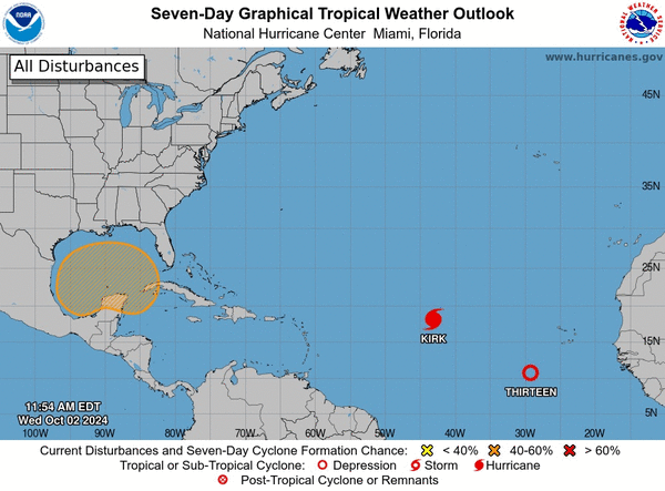
As Hurricane Kirk gained strength and Tropical Depression Thirteen formed Wednesday but were no threat to land in the Atlantic, the National Hurricane Center was keeping track of system that could develop in the Gulf of Mexico and turn toward Florida.
As of the NHC’s 2 p.m. Eastern time tropical outlook, the system that could mean at least heavy rains for Florida next week was for now a broad trough of low pressure with a large area of disorganized showers and thunderstorms running from the southwestern Caribbean Sea up into the southern Gulf of Mexico.
“Environmental conditions could support some gradual development of this system, and a tropical depression could form over the weekend as the broader disturbance moves fully into the Gulf of Mexico,” forecasters said. “Interests along the U.S. Gulf Coast should continue to monitor the progress of this system. Regardless of development, locally heavy rains could occur over portions of Mexico during the next several days and over portions of the Florida Peninsula by the weekend.”
The NHC gives it a 40% chance of development in the next seven days.
The National Weather Service in Melbourne expects some impact in Florida by early next week.
“There continues to be a large amount of inconsistencies in the global models and ensemble guidance especially into early next week,” said NWS meteorologist Kole Fehling as of his 4 a.m. EDT forecast for east Central Florida. “However, global models have trended towards better agreement with the most recent guidance.”
He puts 50%-70% chance for heavy rainfall from Sunday into early next week.
Meanwhile in the Atlantic, an area of low pressure developed into Tropical Depression Thirteen a few hundred miles south-southwest of the Cape Verde Islands with more organized showers and thunderstorms.
As of 11 a.m., the center of TD 13 was located 430 miles southwest of the southernmost Cape Verde Islands moving west at 7 mph with maximum sustained winds of 35 mph.
“A general westward motion is expected for the next day or so followed by a turn more west-northwestward by the weekend,” forecasters said. “Gradual strengthening is forecast, and the depression could become a tropical storm by tonight.”
If it does, it will become Tropical Storm Leslie.
Already spinning in the Atlantic is Hurricane Kirk.
As of the NHC’s 5 a.m. advisory, Kirk was located about 1,200 miles west of the Cape Verde Islands and 1,280 miles east of the Caribbean’s Lesser Antilles moving northwest at 14 mph with sustained winds of 80 mph, which keeps it a Category 1 hurricane.
Hurricane-force winds extend out 30 miles and tropical-force-storm winds extend out 195 miles from its center.
“Additional strengthening is forecast during the next few days, and Kirk is expected to become a major hurricane by Thursday,” forecasters said.
If it does, it would become the third major hurricane of the 2024 Atlantic hurricane season after Beryl and Helene.
The season, which runs from June 1-Nov. 30, has so far produced 12 officials storms including six hurricanes, four tropical storms and a tropical depression as well as one potential tropical cyclone that did not form before making landfall.
After Leslie, the next name on the list is Milton.
_____
©2024 Orlando Sentinel. Visit orlandosentinel.com. Distributed by Tribune Content Agency, LLC.


Comments