'Avoid outdoor burning.' Why the wildfire risk in the Kansas City area is elevated
Published in News & Features
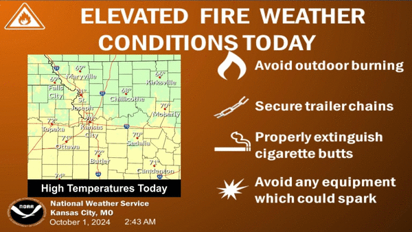
KANSAS CITY, Mo. —People are being advised to avoid outdoor burning Tuesday as the weather combined with an extremely dry September has made conditions ripe for wildfires that ignite to spread rapidly, according to the National Weather Service.
“October greets us with a beautiful fall weather day, with high temperatures ranging from the upper 60s to lower 70s and very low humidity,” the weather service said.
The Kansas City metro temperature is expected to reach 70 degrees, slightly below the 74 degrees typical for this time of year.
Northwesterly winds, with gusts up to 25 mph, are expected in the morning. A drier air mass is expected to move into the area, dropping humidity to 20-30% in the afternoon. This leads to concerns about wildfires late in the morning through mid-afternoon.
The “strongest winds and lowest humidity values aren’t synced, limiting overall concerns,” the weather service said.
Temperatures are expected to tumble into the low to mid-40s overnight into Wednesday morning, tempting some to fire up their furnaces. The urban heat island core of Kansas City should see temperatures remain in the upper 40s.
Unseasonably warm temperatures return to KC
Fall-like weather will be short-lived as temperatures rebound into the upper 70s on Wednesday and the mid to upper 80s on Thursday.
Although another cold front is expected to push through the region, Friday’s temperatures will only be knocked down a few degrees. Temperatures, however, will remain above average.
Temperatures will bounce back over the weekend, reaching 87 degrees on Saturday and 80 degrees on Sunday.
No rain is expected through at least the next seven days.
Warmer than normal temperatures and below normal rainfall are likely Oct. 8 through 14.
September’s dry, warm weather
The climate summary for Kansas City shows that September was warmer and drier than usual, the weather service said on X, formerly Twitter.
The average temperature was 70.2 degrees, which was 1.8 degrees above normal. This past September was the 62nd warmest on record out of 137 years.
Last month, temperatures reached at least 80 degrees on 21 days, making it the 18th September in Kansas City’s history with the most days to see temperatures that warm.
The month’s precipitation was 1.48 inches, 2.56 inches below the normal of 4.04 inches, making it the 26th driest September.
©2024 The Kansas City Star. Visit at kansascity.com. Distributed by Tribune Content Agency, LLC.


Comments