Florida keeping an eye on Caribbean system that could become a storm this week
Published in News & Features
MIAMI — The crowded oceans could spit out another storm this week, right on the heels of Hurricane Helene, and Florida is paying close attention.
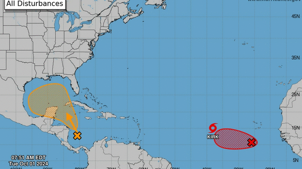
The National Hurricane Center is watching two disturbances that have good shots at becoming storms this week — but one in the Caribbean is a more immediate system to watch.
As of 8 a.m. Tuesday, the hurricane center gave it a 40% chance of developing in the next seven days and a 10% chance of developing in the next two days.
“A tropical depression could form over the next several days while it moves generally northwestward over the northwestern Caribbean Sea and the southern Gulf of Mexico. Interests along the U.S. Gulf Coast should continue to monitor the progress of this system,” forecasters wrote.
Long-range computer models suggest the system could form in a similar spot to Helene — a Category 4 that flooded tens of thousands of homes in Florida and the southeast last week — and move into the Gulf. From there, some of the models show the Florida peninsula as a possible landing spot, but experts warn it’s far too soon to know for sure.
The other disturbance the hurricane center is eyeing is in the far east Atlantic, a broad area of low pressure with a 90% chance of strengthening in the next seven days and an 80% chance of strengthening in the next two.
Early computer models took it west for a few days, but the other storm in front of it — Tropical Storm Kirk — ended up on a northern track that would keep it far from land. Kirk is also expected to become a major Category 3 hurricane as soon as Thursday.
The next name on the list is Leslie.
©2024 Miami Herald. Visit at miamiherald.com. Distributed by Tribune Content Agency, LLC.


Comments