A new storm could form in the Caribbean this week. Florida should watch it
Published in News & Features
The late-season peak of hurricane season is in full swing, and the oceans are getting crowded with storms, including a potential development in the Caribbean that Florida should keep an eye on.
The National Hurricane Center is watching several systems that are projected to stay far away from land, and two disturbances that could develop into something stronger this week.
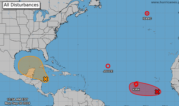
The one to watch is the disturbance in the Caribbean Sea, which could start to develop in the same space that Hurricane Helene did last week. Forecasters said a tropical depression could form and move northwest, up into the Gulf of Mexico.
As of 8 a.m. Monday, the hurricane center gave it a 40% chance of strengthening in the next seven days and no chance of strengthening in the next two days, a downgrade from earlier in the morning.
“While interests in the northwestern Caribbean Sea and along the U.S. Gulf Coast should continue to monitor the progress of this system, the timetable for potential development has shifted later toward late week or this weekend,” forecasters wrote.
In a press conference on Sunday, Gov. Ron DeSantis said state officials were also tracking the would-be storm.
“We’ll hope for the best. Hopefully it doesn’t form and if it does form, hopefully it spares Florida,” he said. “We will be prepared to respond to that and I would just tell Floridians that this is not something you should be freaking out about but it should be something to put on your radar.”
James Spann, a meteorologist for Birmingham’s ABC affiliate, WBMA, said that it was too soon to have any confidence about where the would-be storm could go, but it’s worth watching.
“It is still too early to know the final destination or intensity,” he posted on X. “Most global models push the tropical low into the Florida Peninsula (not the panhandle) in a week or so, but again we simply don’t know how it plays out at this point.”
Elsewhere in the Atlantic
Another disturbance in the far eastern Atlantic has a shot at developing into a tropical depression this week. The hurricane center gave this one an 80% chance of strengthening within the next seven days and a 30% shot at strengthening in the next two days .
It’s too early to know where it could go if it did form, beyond west. The next name on the list is Leslie.
The three other systems in the Atlantic all have forecast tracks from the hurricane center, and all three show paths that keep them away from land.
Post-tropical Cyclone Isaac is north of the Azores, with a track that has it weakening to a tropical depression even further north on Thursday.
Tropical Depression Joyce, in the middle of the Atlantic, has a forecast track headed straight north, very slowly. Forecasters call for it to remain a slow, weak depression through Monday morning and dissipate soon after that.
Tropical Storm Kirk, which is just west of the potential new system, could strengthen into a hurricane as soon as Tuesday. The storm’s projected path curves it northwest but away from land. By Saturday, forecasters said it could be a major Category 3 hurricane.
©2024 Miami Herald. Visit at miamiherald.com. Distributed by Tribune Content Agency, LLC.


Comments