In storms like Hurricane Helene, flooded industrial sites and toxic chemical releases are a silent and growing threat
Published in News & Features
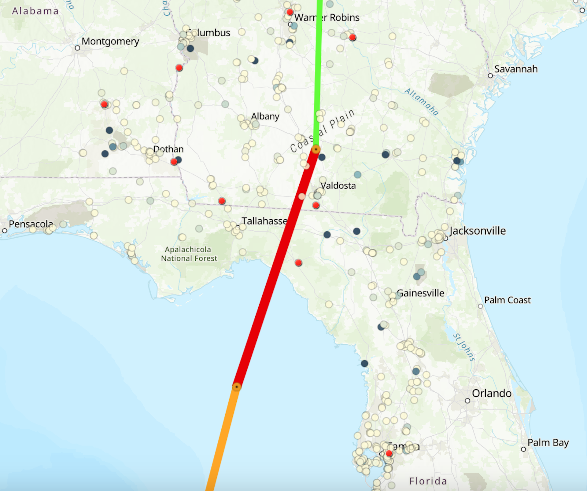

Hundreds of industrial facilities with toxic pollutants were in Hurricane Helene’s path as the powerful storm flooded communities across the Southeast in late September 2024.
Near the coast and into Georgia, Helene swept over paper mills, fertilizer factories and oil and gas storage facilities. Paper mills are among the most polluting industries on the planet – some with thousands of pounds of lead on-site from prior production practices.
Florida officials reported that a retired nuclear power plant just south of Cedar Key experienced a storm surge of as much as 12 feet that inundated buildings and an industrial wastewater pond. Spent nuclear fuel stored at the site, which also flooded during Hurricane Idalia in 2023, was believed to be secure, Bloomberg reported.
Further inland, the storm dumped more than a foot of rain on industrial sites in the Carolinas and Tennessee, some near waterways that quickly flooded with runoff from the mountains.
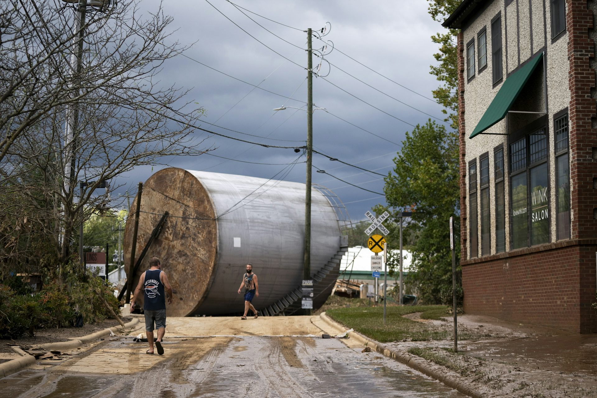
In disasters like these, the industrial damage can unfold over days, and residents may not hear about releases of toxic chemicals into water or the air until days or weeks later, if they find out at all.
Yet pollution releases are common.
After Hurricane Ian broadsided Florida’s western coast in 2022, runoff that included hazardous materials from damaged storage tanks and local fertilizer mining facilities, in addition to millions of gallons of wastewater, was visible from space, spilling across the coastal wetlands into the Gulf of Mexico. A year earlier, Hurricane Ida triggered more than 2,000 reported chemical spills.
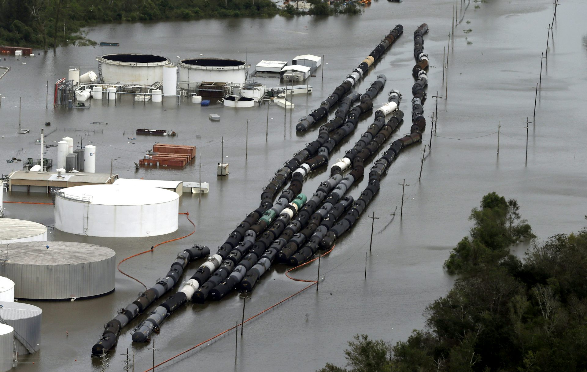
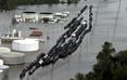
During Hurricane Harvey in 2017, floodwater surrounded chemical facilities near Houston. Some caught fire as cooling systems failed, releasing huge volumes or pollutants into the air. Emergency responders and residents, who didn’t know what risks they might face, blamed the chemicals for causing respiratory illnesses.
Many types of toxic material can spread, settle and change the long-term health and environmental safety of surrounding communities – often with little notice to residents. Our team of environmental sociologists and anthropologists has mapped hazardous industrial sites across the country and paired them with hurricanes’ projected impact maps to help communities hold nearby facilities accountable.
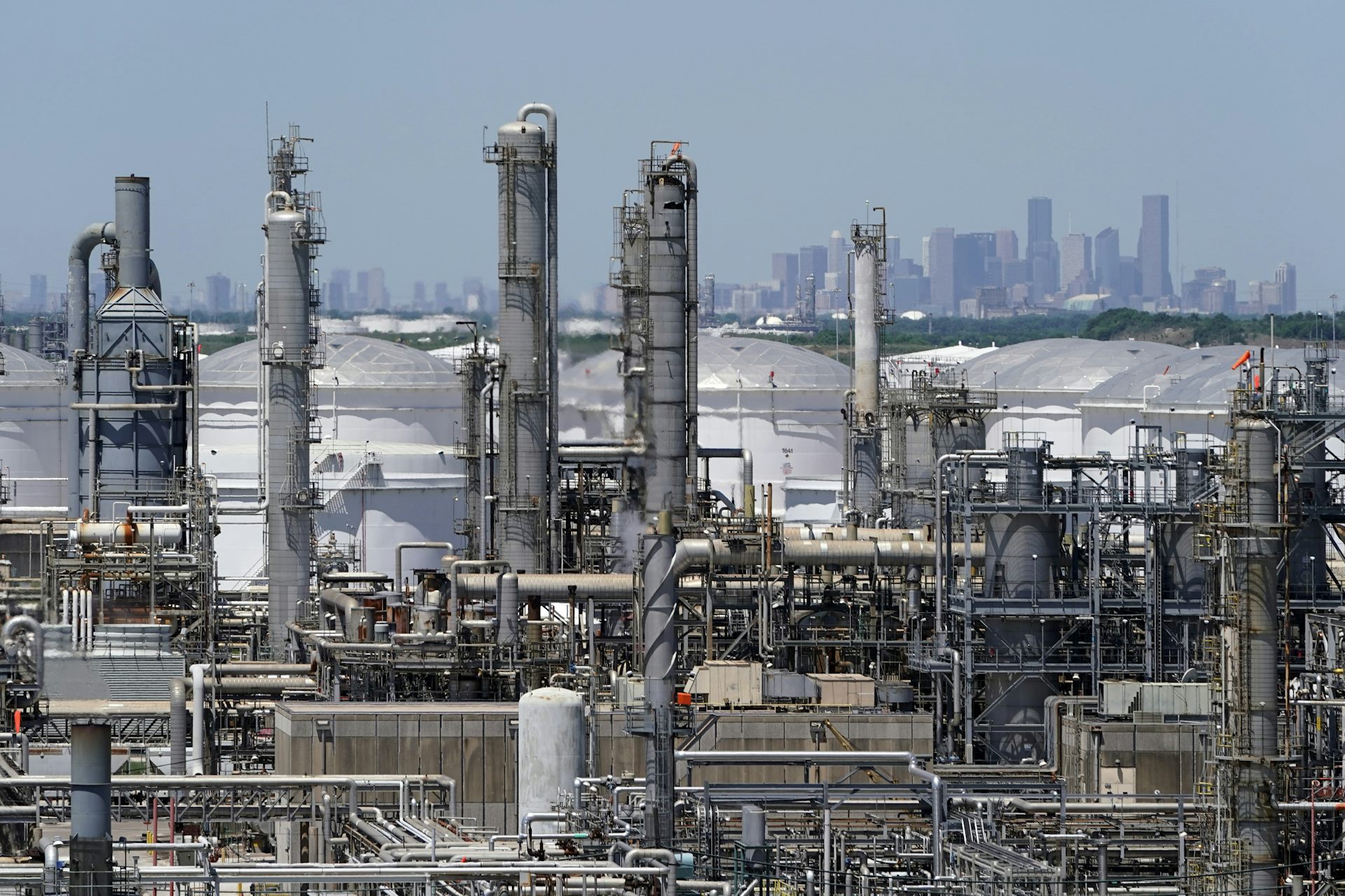
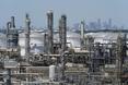
The risks from industrial facilities are most obvious along the U.S. Gulf Coast, where many major petrochemical complexes are clustered in harm’s way. These refineries, factories and storage facilities are often built along rivers or bays for easy shipping access.
But those rivers can also bring storm surge flooding that can raise the ocean by several feet during hurricanes. The storm surge from Helene was over 10 feet above ground level in Florida’s Big Bend and over 6 feet high in Tampa Bay.
A recent study found evidence of two to three times more pollution releases during hurricanes in the Gulf of Mexico than during normal weather from 2005 to 2020.
The effects of these pollution releases fall disproportionately on low-income communities and people of color, further exacerbating environmental health risks.
The statistics are disconcerting, yet they get little attention. That is because hazardous releases remain largely invisible due to limited disclosure requirements and scant public information. Even emergency responders often don’t know exactly which hazardous chemicals they are facing in emergency situations.
The U.S. Environmental Protection Agency requires major polluters to file only very general information about chemicals and on-site risks in their risk management plans. Some large-scale fuel storage facilities, such as those holding liquefied natural gas, are not even required to do that.
These risk management plans outline “worst-case” scenarios and are supposed to be publicly accessible. But, in reality, we and others have found them difficult to access, heavily redacted and housed in federal reading rooms with limited access. The reason local officials and national scientific review panels often give for the secrecy is to protect the facilities from terrorist attack.
Adding to this opacity is the fact that many states – including those along the Gulf – suspend restrictions on pollution releases during emergency declarations. Meanwhile, real-time incident notifications from the National Response Center – the federal government’s repository for all chemical discharges into the environment – typically lag by a week or more,
We believe this limited public information on rising chemical threats from our changing climate should be front-page news every hurricane season. Communities should be aware of the risks of hosting vulnerable industrial infrastructure, particularly as rising global temperatures increase the risk of extreme downpours and powerful hurricanes.
To help communities understand their risks, our team at Rice University’s new Center for Coastal Futures and Adaptive Resilience investigates how industrial communities in flood-prone areas nationwide can better adapt to such threats, socially as well as technologically.
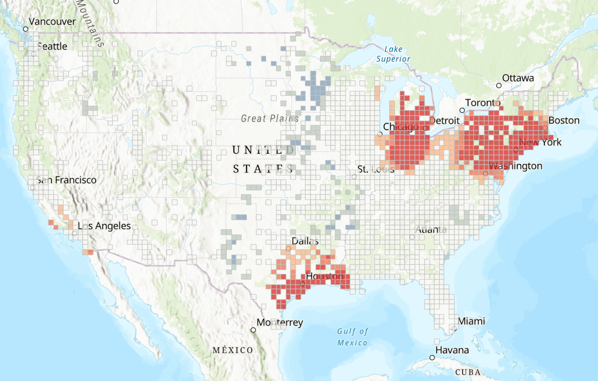
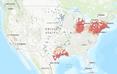
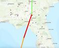
Our interactive map shows where elevated future flood risks threaten to inundate major polluters that we identify using the EPA’s Toxic Release Inventory.
The U.S. has several hot spots with clusters of flood-prone polluters. Houston’s Ship Channel, Chicago’s waterfront steel industries and the harbors at Los Angeles and New York/New Jersey are among the biggest.
But, as Helene revealed, there can also be great concern in less obvious spots. Inland, particularly in the mountains, runoff can quickly turn normally tame rivers into fast-rising torrents. The French Broad River at Asheville, North Carolina, rose about 12 feet in 12 hours during Helene and set a new flood stage record.
When hurricanes and tropical storms are headed for the U.S., our interactive maps now show where major polluters are located in the storm’s projected cone of impact. The maps identify hazardous flood-prone facilities down to the address, anywhere in the country.
Knowing where these sites are located is only the first step. Often, it’s up to communities themselves, many of them already overexposed and historically underserved, to raise concerns and demand strategies for mitigating the health, economic and environmental risks that industrial sites at risk of flooding and other damage can pose.
These discussions can’t wait until a disaster is on the way. By knowing where these risks may be, communities can take steps now to build a safer future.
This article is republished from The Conversation, a nonprofit, independent news organization bringing you facts and trustworthy analysis to help you make sense of our complex world. It was written by: James R. Elliott, Rice University; Dominic Boyer, Rice University, and Phylicia Lee Brown, Rice University
Read more:
Hurricanes don’t stop at the coast – these mountain towns know how severe inland flood damage can be, and they’re watching Helene
More cities are getting hit by compounding disasters, which complicates everything from insurance to rebuilding
Flood maps show US vastly underestimates contamination risk at old industrial sites
James R. Elliott receives funding from the National Science Foundation and the National Renewable Energy Lab.
Dominic Boyer receives funding from the National Science Foundation, NOAA and Texas Sea Grant.
Phylicia Lee Brown has nothing to disclose.


Comments