The U.S. Gulf Coast and Caribbean should keep eyes on another potential system, NHC says
Published in News & Features
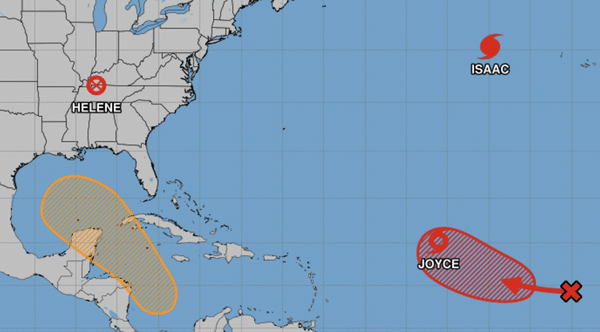
One system headed for the Gulf of Mexico should have the attention of the United States, Cuba and Mexico, and two systems with development chances follow a tropical storm in the Atlantic Ocean.
All that and Hurricane Isaac are in the National Hurricane Center’s 8 a.m. update on the weather system activity in the Atlantic region.
A disturbance in the Caribbean
What the hurricane center calls “a broad area of low pressure” over the western Caribbean Sea could become a tropical storm in a few days as it “meanders” west-northwest.
“This system is then expected to move northwestward into the Gulf of Mexico during the latter portion of this week, and interests in the northwestern Caribbean Sea and along the U.S. Gulf Coast should monitor its progress,” the hurricane center said.
Formation chance over the next two days: near zero.
Formation chance over the next seven days: 50%.
A wave with no clear direction
A tropical wave off Africa’s west coast could show “gradual development” during the week as it moves west or west-northwest into the Atlantic.
Formation chance over the next two days: near zero.
Formation chance over the next seven days: 20%.
Tropical Storm Joyce
Where is Joyce: About 1,000 miles east-northeast of the Northern Leeward Islands.
Where is Joyce going: Joyce is heading northwest at 9 mph and “this general motion with a decrease in forward speed is expected through (Sunday night). A turn toward the north and north-northeast is forecast on Monday and Tuesday.”
Joyce’s maximum sustained winds: 45 mph. Tropical storm level winds blow up to 105 miles from Joyce’s center.
Watches and warnings: None.
“Weakening is forecast, and Joyce is expected to become a depression by early Monday and then a remnant low on Tuesday,” the hurricane center said.
A disturbance following Joyce
“Showers and thunderstorms associated with an elongated area of low pressure located a few hundred miles west-southwest of the Cabo Verde Islands have become better organized” since Saturday, the hurricane center said.
This is expected to be a tropical depression by Thursday as it moves west, then northwest across the Atlantic Ocean.
Formation chance over the next two days: 60%.
Formation chance over the next seven days: 80%.
Hurricane Isaac
Where is Isaac: About 590 miles northwest of the Azores. Isaac’s hurricane force winds extend to 45 miles from the center. That’s 205 miles from the center for tropical storm- force winds.
Where is Isaac going: Isaac is heading northeast at 13 mph and “this general motion is expected to continue during the next couple of days, followed by a turn toward the north-northeast to north on Tuesday.”
Isaac’s maximum sustained winds: 80 mph.
Watches and warnings: “Swells generated by Isaac and a large wind fetch from a deep-layer trough will affect the Azores over the next few days. These swells are likely to cause life-threatening surf and rip current conditions.”
Isaac’s life as a hurricane is expected to be done by Monday afternoon.
_____
©2024 Miami Herald. Visit miamiherald.com. Distributed by Tribune Content Agency, LLC.


Comments