Hurricane center tracks newly formed Tropical Storm Joyce, 2 other systems on top of Tropical Storm Helene, Hurricane Isaac
Published in News & Features


ORLANDO, Fla. — The National Hurricane Center continued to keeps its focus Friday on what had been Category 4 major Hurricane Helene as it moved inland as a tropical storm, but also was keeping tabs on newly formed Tropical Storm Joyce and Hurricane Isaac in the Atlantic and two more systems with a chance to develop into the season’s next tropical depression or storm.
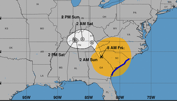
As of 8 a.m., Tropical Storm Helene, that made landfall on Florida’s Big Bend near Perry at around 11:10 p.m. Thursday, had sustained winds of 60 mph as it moved north at 30 mph located about 35 miles south-southwest of Clemson, South Carolina and 80 miles east-northeast of Atlantic. Tropical-storm-force winds extend out 275 miles.
A wind gust of 72 mph was recently recorded at Brasstown Bald, Georgia while Dewees Island, South Carolina reported a sustained wind of 46 mph and gust of 62 mph.
A tropical storm warning remained in place for Altamaha Sound north to Little River Inlet on the southeast U.S. coast while a storm surge warning remained in effect on Florida’s Gulf Coast from Indian Pass in the Panhandle south to the middle of Longboat Key, Florida as well as Tampa Bay.
“Helene is expected to turn northwestward and slow down over the Tennessee Valley later today and Saturday,” forecasters said. “Continued weakening is expected, and Helene is expected to become a post-tropical low this afternoon or tonight.”
The NHC warned its damaging wind gusts will continue to penetrate far inland across the southeast U.S. including over the higher terrain of the southern Appalachians.
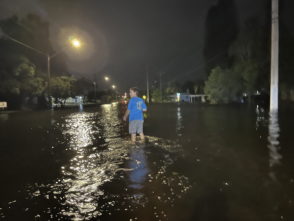
Florida, meanwhile, was cleaning up from the massive storm surge and damaging winds that plagued the Gulf Coast.
The system left at least two people dead in Florida — one when a driver on Interstate 4 was struck by a falling overhead sign near Ybor City and a second in Dixie County when a tree fell on a house, according to Florida Gov. Ron DeSantis.
Georgia had two reported deaths from a tornado that was spawned on Thursday.
More than 1.1 million customers were still without power as of 9 a.m., according to poweroutage.us.
Storm surge plagued Gulf Coast counties from southwest Florida up into the Panhandle with nearly 8 feet over normal levels reported in Cedar Key near landfall to the north.
Colorado State University meteorologist Philip Klotzbach said that with 140 mph winds and stronger gusts, the landfall of Hurricane Helene marked the most powerful hurricane to hit the region since records were kept beginning in 1851.
“The old record was the Cedar Keys Hurricane (1896) with max winds of 125 mph,” he posted on X.
Ahead of landfall, the NHC had warned of storm surge along the Big Bend that could reach at least 20 feet high while lower but still dangerous levels were forecast all the way down the Gulf Coast to Naples.
Meanwhile in the Atlantic, the season saw its sixth hurricane develop with the formation of Hurricane Isaac and formation of the season’s 10th named storm with Tropical Storm Joyce.
As of 5 a.m. Friday, Hurricane Isaac was located about 1,175 miles west of the Azores and 980 miles east-northeast of Bermuda with 75 mph sustained winds moving east at 12 mph.
“A gradual turn to the east-northeast is expected over the next several days,” forecasters said. “Additional strengthening is expected during the next day or so followed by gradual weakening by the end of this weekend.”
Hurricane-force winds extend out 15 miles and tropical-storm-force winds extend outward up to 70 miles from the center, but for now it is no threat to land.
Tropical Storm Joyce developed in the central Atlantic about midway between the Cape Verde Islands and Caribbean’s Lesser Antilles.
As of 11 a.m., Joyce had sustained winds of 40 mph as it moved northwest at 13 mph located about 1,325 miles east of the northern Leeward Islands. Tropical-storm-force winds extend out 70 miles from its center.
It’s no threat to land and is expected to slow its forward speed through Sunday and turn to the north in the open ocean.
“Gradual strengthening is expected through Saturday, followed by gradual weakening through early next week,” forecasters said.
And the NHC was keeping two other systems in the Atlantic and Caribbean with a chance to become the next season’s tropical depression or storm.
One is a forecasted area of low pressure that could form over the western Caribbean Sea by the middle of next week.
“Environmental conditions are expected to be conducive for slow development thereafter while the system moves generally northwestward, potentially entering the Gulf of Mexico by the end of next week,” forecasters said.
The NHC said it had a 30% chance to develop in the next seven days.
And new on Friday, the NHC also began forecasting an area of low pressure to form over the eastern tropical Atlantic by the early to middle part of next week.
“Environmental conditions are expected to be conducive for slow development thereafter while the system moves generally northwestward at 10 to 15 mph,” forecasters said.
The NHC gave it a 20% chance to develop in the next seven days.
After Joyce, the next names on the 2024 Atlantic hurricane season list are Kirk and Leslie.
The season so far has produced nine named storms including hurricanes Beryl, Debby, Ernesto, Francine, Helene and Isaac.
Four of those — Beryl, Debby, Francine and Helene — all hit the U.S. Gulf Coast, something that has happened only in five other years since 1851 — 1886, 1909, 1985, 2005 and 2020, according to Klotzbach.
Both Debby and Helene struck Florida within just eight weeks of one another near the same area struck by Hurricane Idalia in 2023, all within about 15 miles of one another.
Helene also became the ninth most powerful hurricane to hit Florida since 1900 with a pressure recorded at 938 mb at landfall, Klotzbach said.
2018’s Category 5 Hurricane Michael that hit Florida’s Panhandle had been the strongest in recent Florida history with 919 mb pressure. The 1935 Labor day hurricane remains the strongest on record at 892 mb.
Helene’s landfall as a major hurricane marks the fifth year in a row that at least one major hurricane has made a U.S. landfall, Klotzbach said. Hurricanes Laura and Zeta struck in 2020, Ida in 2021, Ian in 2022 and Idalia in 2023.
______
©2024 Orlando Sentinel. Visit at orlandosentinel.com. Distributed by Tribune Content Agency, LLC.


Comments