How will Hurricane Helene affect South Florida? Tropical storm and tornado watches
Published in News & Features
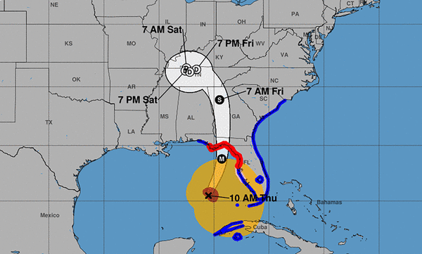
MIAMI — Although Miami-Dade and Broward counties will be spared the worst of Hurricane Helene, which continues to make its way toward Florida’s Big Bend with 100+ mph winds, the National Weather Service cautions that South Florida will still feel its impact.
All of South Florida has been under a tropical storm warning since Wednesday and that continues into Thursday, as tropical storm wind gusts and heavy sporadic rain are expected throughout the day. Flood and tornado watches are also in the mix.
Broward County Public Schools has canceled Thursday classes while Miami Dade Public Schools decided to remain open.
“The area is not going to see the strongest impacts from the storm,” said NWS meterologist Will Redman .“Along the outer bands of the storm, we’re going to have some stronger wind gusts, which have already been happening overnight and early this morning.”
The strongest wind gust felt so far was 64 mph at Fort Lauderdale International Airport, according to the weather service. Right behind it is Naples with 56 mph wind and Pembroke Pines with 55 mph. In Miami, Morningside Park saw a wind gust of 49 mph.
The weather service warns that similar conditions are possible throughout the day as Helene’s bands sweep through.
In the Florida Keys, the National Weather Service has reported a 61 mph wind gust in Cudjoe Key from Helene’s broad feeder bands.
©2024 Miami Herald. Visit at miamiherald.com. Distributed by Tribune Content Agency, LLC.


Comments