Hurricane Helene surges to major Category 3 storm, forecast for 'catastrophic' Florida landfall
Published in News & Features
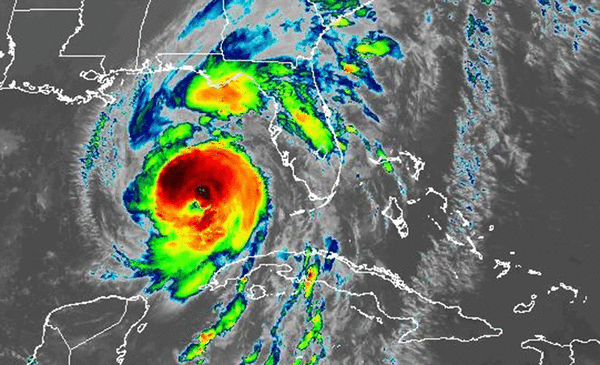
ORLANDO, Fla. — Hurricane Helene intensified into a major Category 3 hurricane on Thursday with 120 mph sustained winds, with the National Hurricane Center predicting it will grow further bringing devastation to Florida’s Gulf Coast and inland toward Tallahassee.
“A catastrophic and deadly storm surge is likely along portions of the Florida Big Bend coast, where inundation could reach as high as 20 feet above ground level, along with destructive waves,” said NHC senior hurricane specialist Jack Beven. “There is also a danger of life-threatening storm surge along the remainder of the west coast of the Florida Peninsula. Residents in those areas should follow advice given by local officials and evacuate if told to do so.”
The special update came at 2:25 p.m. EDT after the Air Force Hurricane Hunters found that the maximum sustained winds had increased to near 120 mph located about 170 miles west-southwest of Tampa and 205 miles south of Apalachicola as it moved north-northeast at 16 mph.
“Additional strengthening is expected before Helene makes landfall in the Florida Big Bend this evening,” the update reads. It could reach Category 4 with 130 mph winds.
Hurricane-force winds extend out 60 miles and tropical-storm-force winds extend out 345 miles from the center.
The National Weather Service also issued a tornado watch covering the majority of Florida’s peninsula from north-central Florida down to the Keys until 8 p.m.
Nearly 20 tornado warnings have been issued across Florida since midnight through 10 a.m. including South Florida warnings in Wellington, Clewiston and Port St. Lucie, and recent warnings in Brevard and Volusia counties.
Power outages are beginning to pop up across the state, with nearly 100,000 customers out by 3 p.m., according to poweroutage.us.
Wind gusts over 60 mph forced the Florida Highway Patrol to shut down the Sunshine Skyway Bridge across Tampa Bay in the afternoon, and later shut down the Howard Frankland Bridge that connects Tampa to St. Petersburg.
The forecast intensity has it reaching Category 3 major hurricane strength with 120 mph sustained winds and 145 mph gusts by Thursday night ahead of landfall, but it could intensify further.
“Forward speed is picking up now,” said NHC Director Michael Brennan. “That speed is going to continue to increase to over 20 mph by the time Helene makes landfall later this evening ... We’ve seen data from both the NOAA and Air Force hurricane hunter aircraft that shows Helene his strengthening, getting better organized, forming an eye wall, and we’re expecting steady to rapid intensification to continue. Before Helene makes landfall later tonight as a Category 3 or possibly even Category 4 hurricane, but the impacts are what’s going to be most important.”
A Category 4 hurricane would mean 130 mph sustained winds and gusts of 160 mph. Brennan warned for those powerful winds north of landfall up into the Tallahassee area and even further into Georgia.
“Everybody in that region needs to be prepared for hurricane-force winds, the potential for long-duration, widespread power outages, structural damage, tree damage, trees falling on homes, out on cars or people if you’re outside, and the potential for catastrophic wind damage near where the core of Helene makes landfall on the Florida Big Bend coast.”
“As a result, storm surge, wind and rainfall impacts will extend well away from the center and outside the forecast cone, particularly on the east side,” Beven said. “In addition, the fast forward speed when Helene moves inland will result in a far inland penetration of strong winds over parts of the southeastern United States, including strong gusts over higher terrain of the southern Appalachians. ... A higher-than-normal gust factor is indicated in the official forecast while Helene is inland.”
Gov. Ron DeSantis spoke at a 9 a.m. press conference from the State Emergency Operations Center in Tallahassee with a status update.
“This is a very large storm, so you’re going to see tropical weather that’s going to extend hundreds of miles away from the center of the storm,” he said.
But even though landfall will be in North Florida, Gulf Coast cities including Sarasota and Tampa are not out of danger.
“Because it’s such a big storm, it’s churning a lot of water, and so you’re going to see surge all up and down the west coast of Florida,” he said. “The water is going to rise, and that is going to create hazards as well. So just because you’re outside the cone, and I think a lot of those parts on the west coast of Florida are probably outside the cone, that does not mean that you’re not going to see significant impacts.”
Already surge on the Gulf Coast is causing minor flooding in southwest Florida such as Charlotte and Lee counties and in Tampa Bay’s Pinellas and Hillsborough counties.
The town of Fort Myers Beach posted images of flooding up to the windows of some beachside buildings.
Earlier surge flooded streets in Key West and the lower Florida Keys.
DeSantis addressed how hard a hit the state’s capital city could take if the course remains on track.
“If you look at the track that we were talking about last night, that was a track that we have not seen of that magnitude hit Tallahassee in anybody’s lifetime, and if that were to happen, there is just going to be a lot of debris,” he said. “It is going to push down a lot of trees, and it will cause significant damage.”
Any shift in the storm’s path farther east, though, will spare Tallahassee some of the more devastating winds.
“We always prepare for the worst and hope for the best,” he said. “You have seen the models nudge it more to the east, and if you’re on the west side of the storm, the amount of damage is just less than if you’re on the east side of the storm.”
The Florida Division of Emergency Management has been responding to 1,100 requests from counties with provision of requests such as generators and high-water vehicles.
Also the state will have 30,000 linemen staged to respond to expected power outages after the storm passes.
“The storm, it’s coming,” he said. “We’re already seeing some effects in the southern part of the state. We’re going to continue to see conditions deteriorate throughout the rest of the day, and we are anticipating a landfall as likely a major hurricane sometime this evening.”
As of noon, the NWS in Melbourne said Vero Beach had seen a 59 mph wind gust while wind gusts of 43 mph were recorded at Cape Canaveral Space Force Station, 41 mph at Daytona Beach International Airport, 38 at Melbourne International Airport and 37 mph at Orlando International Airport.
On Wednesday, he said mandatory evacuation orders were in place for some parts of 16 counties.
“This thing’s going to be whipping through,” he said. “It’s going to cause a lot of churn, and is going to drive that water and so it is going to be a significant water event. ... Remember, you hide from wind, but you run from the water.”
He said the state had partnered with Uber for free rides for those in those evacuation zones. He also said Visit Florida has activated emergency accommodation modules on Expedia and Priceline for hotel availability.
The breadth of the storm has already prompted tropical storm warnings to extend to the entirety of Florida’s east coast and into Georgia on top of Florida’s Gulf Coast and Panhandle hurricane warnings and watches.
And several coastal counties have ordered evacuations as storm surge was a threat from southwest Florida up to the Panhandle including up to 20 feet in the Big Bend, up to 8 feet in Tampa Bay and 5 feet in Charlotte Harbor.
“It is going to be a big storm, and by big I mean not intensity, I mean size,” said NHC Deputy Director Jaime Rhome. “And big storms cause big problems. And that’s one of the take-home messages that I need you to understand.”
Hurricane warnings are in place for the Gulf Coast from the Anclote River near Tarpon Springs north to Mexico Beach, Florida on the Panhandle.
A hurricane watch is in place for Englewood north the Anclote River and Tampa Bay.
Tropical storm warnings are in effect for the Dry Tortugas, all of the Florida Keys, the Florida west coast from Flamingo to the Anclote River and Tampa Bay, west of Mexico Beach on the Panhandle to the Okaloosa/Walton county line and the east coast of the Florida peninsula from Flamingo around and north up to the Little River Inlet, South Carolina.
Tropical storm warnings are in place as well for Lake Okeechobee and inland warnings for all of Central Florida including Brevard, Lake, Marion, Orange, Osceola, Polk, Seminole, Sumter and Volusia counties. The western inland portion of Marion County is under a hurricane warning.
“Hurricane conditions are expected within the U.S. hurricane warning area late today, with tropical storm conditions beginning this morning,” Beven said. “Tropical storm conditions are spreading across the Florida Keys at this time, and they are expected to spread northward across the rest of Florida, Georgia, and South Carolina through tonight.”
The big worry for more of the Gulf Coast is storm surge with a warning in place from Mexico Beach in the Panhandle all the way south to Flamingo near the bottom of the Florida peninsula’s southwest coast, but also vulnerable Tampa Bay and Charlotte Harbor.
Storm surge as high as 20 feet could be seen in the area directly near landfall.
“It’s going to push a big swath of storm surge across the western portions of the Florida peninsula,” Rhome said. “This area is really, really vulnerable to storm surge. It’s not going to take a lot of wind, and even tropical-storm-force winds along the Florida West Coast produce significant and life threatening storm surge.”
The NHC warned surge and high tide could lead to 15-20 feet from Carrabelle to the Suwannee River, 10-15 feet from Apalachicola to Carrabelle and from the Suwannee to Chassahowitzka, 8-12 feet from Chassahowitzka to the Anclote River near Tarpon Springs, from 6-10 feet from Indian Pass in the Panhandle to Apalachicola, 5-8 feet from the Anclote River south to the middle of Longboat Key as well as Tampa Bay, 4-7 feet from the middle of Longboat Key south to Englewood and 3-5 feet from east of Mexico Beach to Indian Pass, Englewood south to Flamingo and Charlotte Harbor.
“On the forecast track, Helene will move across the eastern Gulf of Mexico today and cross the Florida Big Bend coast this evening or early Friday morning,” Beven said. “After landfall, Helene is expected to turn northwestward and slow down over the Tennessee Valley on Friday and Saturday.”
Helene is forecast to drop 6-12 inches of rain with some areas getting up to 18 inches across the southeast United States.
“This rainfall will likely result in areas of considerable flash and urban flooding, with areas of significant river flooding,” forecasters said. “Landslides are possible in areas of steep terrain in the southern Appalachians.”
Inland tropical storm watches are in place deep into the U.S. up into Georgia including Atlanta as well as western South Carolina and western North Carolina.
“We don’t normally issue tropical storm watches this far inland, especially here, over the Appalachians area,” Rhome said. “So that’s unusual. You really need to be paying attention. There’s also a big flood threat.”
The NHC also warns tornadoes could form over the western Florida peninsula and southern Alabama with the risk growing on Thursday and expanding across Florida and into parts of Georgia and South Carolina.
Helene formed from Potential Tropical Cyclone Nine as a tropical storm on Tuesday morning, and has picked up steam since developing into a hurricane off the coast of the Yucatan Peninsula on Wednesday morning before entering the Gulf of Mexico.
“The wind swath is going to be huge with this system, and it’s basically going to carve a path right over a good portion of the Florida peninsula, including the highly populated I-4 corridor,” Rhome said. “So if you’re watching from Tampa and Orlando, you’re going to have a big wind event with this, no matter where it goes with respect to the track.”
The storm’s center has a likely target of the Big Bend, similar to this year’s Hurricane Debby and 2023’s Hurricane Idalia with a tighter cone of uncertainty 12 hours out from landfall that ranges from near east of Apalachicola to west of Keaton Beach.
“All indications are a significant hurricane impacting the Florida Big Bend, but, and this is a big but, the hazards are going to be well removed from the center and well removed from the cone,” Rhome said. “So I don’t want you to look at the cone and say, ‘I’m out of the cone,’ or ‘I’m on the edge of the cone,’ because this wind field, the wind field with this system, is going to be really large — larger than you’re used to seeing with a traditional hurricane.”
DeSantis urged residents to listen to local evacuation orders, and avoid the tragedy seen in 2022’s Hurricane Ian that killed 149 people in Florida, most of whom were caught in major storm surge in southwest Florida.
“The field is so big with the winds and it’s going to churn up a lot of surge that you’re likely to see something significant, particularly in the barrier islands and those low lying areas,” he said. “So we always say you can hide from the wind, especially with Florida structures that have been built in modern times, but you run from the water, because if that water really does come crashing in, it’s not a lot you can do about it at that point.”
Each county has designated shelters, including at least one that will let residents take their pets.
“You don’t have to get in your car and drive 350 miles away. You can evacuate safely to higher ground,” he said. “There’s shelters, there’s hotels, friends’ houses, family. All that is fine.”
People, including some in mobile or manufactured homes, can find out if they are under an evacuation order at floridadisaster.org.
He reiterated that even though landfall will be on the Gulf Coast, the east side of the storm will cause havoc across the entire peninsula.
“You’re going to see the more violent side of the storm. It’s going to whip up surge. It’s going to produce high winds that are going to impact the Florida peninsula from Tampa Bay all the way across to the Atlantic coast of Florida,” he said.
DeSantis earlier this week issued a pair of state of emergency orders covering 61 of Florida’s 67 counties. President Joe Biden approved federal disaster assistance that authorizes FEMA to coordinate all disaster relief efforts for 28 of those counties. DeSantis said he would revisit their request to see if the federal order can be expanded, which would help refund preparations some of the cities and counties in effected areas have to make.
There are 3,500 Florida National Guard soldiers ready to assist with post-storm assistance, which can be surged to 5,500 if necessary. The state has also mobilized more than 250 from the Florida State Guard as well as personnel from the Florida Fish and Wildlife Commission, Florida Department of Law Enforcement, county sheriffs and city police forces.
Also late Wednesday, the NHC said Tropical Storm Isaac formed in the north Atlantic.
As of 11 a.m. Thursday, the system was located about 1,345 miles west of the Azores and 820 miles east-northeast of Bermuda with 50 mph sustained winds moving east at 12 mph.
“A turn toward the east-northeast or northeast is expected by the weekend, along with a slight increase in forward speed,” forecasters said. “Strengthening is forecast, and Isaac is expected reach or be near hurricane strength by late Friday or early Saturday.”
Tropical-storm-force winds extend outward up to 70 miles from the center, but for now it is no threat to land.
The NHC was tracking two more systems in the Atlantic basin with a chance to become a tropical depression or storm.
As of the NHC’s 2 p.m. tropical outlook Thursday, the most likely was a broad low-pressure system associated with a tropical wave located several hundred miles west of the Cape Verde Islands has been producing more organized shower and thunderstorm activity.
“Recent satellite imagery suggests the system does not yet have a well-defined surface circulation,” forecasters said. “However, environmental conditions are expected to be conducive for further development. A tropical depression is expected to form later today or tomorrow while the disturbance moves generally westward to west-northwestward at 10 to 15 mph.”
It’s forecast to slow down and turn north late Friday and Saturday, and is no threat to land.
The NHC gives it a 90% chance to develop in the next two days and 90% in the next seven.
The next name on the 2024 Atlantic hurricane season list is Joyce.
New on Thursday, the NHC began forecasting an area of low pressure to form over the western Caribbean by the middle of next week.
“Environmental conditions are expected to be conducive for slow development thereafter, while the system moves generally northwestward,” forecasters said.
The NHC gives it a 20% chance of development in the next seven days.
Hurricane season runs from June 1-Nov. 30, with the height of hurricane development running from mid-August into October.
---------
©2024 Orlando Sentinel. Visit at orlandosentinel.com. Distributed by Tribune Content Agency, LLC.


Comments