Entire Florida coast under warnings for Tropical Storm Helene; landfall forecast in Big Bend region
Published in News & Features
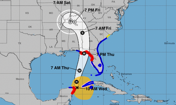
The entire coast of Florida is under various warnings from Tropical Storm Helene, which is expected to intensify rapidly into a hurricane and grow in size as it moves north along the state’s Gulf coast during the day Wednesday.
Helene is forecast to make landfall in Florida’s Big Bend region early Thursday as a major hurricane — Category 3 or higher — but its impacts will be felt over a large area of the state east of the storm’s center.
A tropical storm warning was extended Wednesday morning to include the entire coast of the state, including Palm Beach, Broward and Miami-Dade counties in South Florida. A hurricane warning is in effect on the west coast from north of Tampa Bay to Mexico Beach on the Panhandle.
The storm will likely be quite wide, enhancing the risk of widespread storm surge. “There is a danger of life-threatening storm surge along the entire west coast of the Florida Peninsula and Florida Big Bend,” said the hurricane center said. “The highest inundation levels are expected along the coast of the Florida Big Bend. Residents in those areas should follow advice given by local officials and evacuate if told to do so.”
Mandatory and voluntary evacuation orders are in place for at least 13 counties, the Florida Division of Emergency Management said in a post on X.
There is the possibility of 5-8 feet of surge hitting the Tampa area, if peak surge were to hit at high tide, the National Hurricane Center estimated. The greatest threat of surge was potentially 10-15 feet in the area near the Ochlockonee River to Chassahowitzka.
In addition to Tampa, storm surge warnings were in effect from Indian Pass in the Panhandle south to Charlotte Harbor and Flamingo (3-5 feet) and coastal Collier County.
A flood watch is also in effect for Collier, Hendry and Glades counties for Wednesday and Thursday.
The cone of probability currently includes Tampa and reaches into the western panhandle near Pensacola.
“It’s important that people don’t get wedded to these cones,” said Gov. Ron DeSantis. “You can be out of the cone and still have major impacts. And the farther east this goes, it may not have as much runway for intensification, but it brings in the entire west coast of Florida for potential significant storm surge.”
Currently Tropical Storm Helene, it is expected to become a hurricane within hours, then intensify into a major hurricane with winds up to 115 mph before it approaches the northeastern Gulf Coast on Thursday, the National Hurricane Center said.
The large width of the storm is a concern.
“Of equal importance to the forecast intensity is Helene’s forecast size,” the hurricane center said Tuesday evening. “Helene’s forecast radii are at the 90th percentile of major hurricane size at similar latitudes, and therefore storm surge, wind, and rainfall impacts will likely extend well away from the center and outside the forecast cone, particularly on the east side.”
Because of the storm threat, DeSantis issued a state of emergency in 61 of Florida’s 67 counties. Palm Beach, Broward and Miami-Dade counties are some of the few that are not currently under a state of emergency. President Joe Biden on Tuesday approved an emergency declaration for Florida.
“There’s some similarities to the track that was taken on Hurricane Michael,” said DeSantis at a Tuesday morning news conference. “The thought is that when it’s over the Gulf, especially the more north it goes, rather than east, it has a chance to have a rapid intensification.”
Florida State University’s Tallahassee campus will be closed from Wednesday morning until Sunday night. All University of South Florida campuses will be closed Wednesday through Friday. Florida A&M University cancelled classes beginning Wednesday afternoon through Friday. Several school districts in the state will also close campuses, and government offices and buildings will be closed in many counties.
As of Tuesday evening, Port Canaveral’s status hotline says the port remains open but is “reducing operations.” The port’s website as of Tuesday evening says it remains open “but anticipates possible limited waterside and vessel shoreside Port operations will follow as conditions change.”
Helene’s center will pass near the northeastern coast of the Yucatan Peninsula at near-hurricane strength on Wednesday before moving over the eastern Gulf of Mexico Wednesday and Thursday. It will become a major hurricane Thursday while over the eastern Gulf and reach Florida’s Big Bend coast late Thursday, the hurricane center said.
Kevin Guthrie, executive director for the Florida Division of Emergency Management, said at the news conference that system will produce tropical storm-force winds in excess of 250 miles from the center. “That will encompass most of the peninsula from the space coast all the way through the first coast … and the entire coastal portion of the west coast of Florida,” he said.
The National Weather Service Miami in a briefing Tuesday evening that all of South Florida remains at risk of local to moderate flooding Wednesday through Friday, along with possible brief isolated tornadoes Wednesday and Thursday.
All of South Florida could also potentially see squalls of tropical-storm-force winds late Wednesday and Thursday, between 39 mph and 57 mph, according to NWS Miami. Fort Lauderdale to West Palm Beach has about a 15% to 20% chance of seeing sustained tropical-storm-force winds.
As of 5 a.m. Wednesday, Helene was located 45 miles east-northeast of Cozumel, Mexico, and 120 miles southwest of the western tip of Cuba, moving northwest at 9 mph. Helene’s sustained winds had increased to 65 mph. Tropical storm-force winds extend 175 miles east of the center.
Meanwhile, a tropical depression is likely to form by later this week from a tropical wave in the far eastern Atlantic, forecasters said. The system is expected to move west to west-northwest.
As of 2 a.m. Wednesday, the disturbance has an 80% chance of developing in the next seven days and a 50% chance in the next two days, up slightly from earlier in the day.
Lastly, forecasters are also watching for potential tropical development from a disturbance located northeast of Bermuda on Wednesday.
Experts at Colorado State University issued an updated two-week forecast Sept. 17, calling for a normal of hurricane activity. The forecast says it is very unlikely there will be an above-normal amount of activity through the next two weeks.
Hurricane season runs from June 1-Nov. 30, but the height of storm production runs from mid-August into October.
This is a developing story, so check back for updates. Click here to have breaking news alerts sent directly to your inbox.
©2024 South Florida Sun Sentinel. Visit at sun-sentinel.com. Distributed by Tribune Content Agency, LLC.


Comments