Current News
/ArcaMax
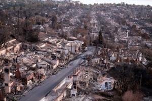
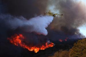
California fires show states' 'last resort' insurance plans could be overwhelmed
In the months before thousands of Los Angeles homes went up in flames, property insurance companies dropped coverage in many neighborhoods of the city, citing the growing wildfire risks caused by climate change.
As a result, a fast-growing number of California residents have switched to a state-backed “last resort” insurance plan. That plan...Read more
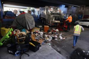
After SCOTUS ruling, Bay Area big cities vowed to close more homeless camps. But have they ramped up sweeps?
After a landmark U.S. Supreme Court ruling last summer granted local governments broad new authority to clear homeless camps, the mayors of the Bay Area’s three major cities vowed to ramp up sweeps.
San Jose and Oakland appear to be making good on that promise by escalating encampment enforcement in recent months, according to a Bay Area News...Read more

Fearing rights “still could be taken away,” Coloradans stock up on morning-after pills, schedule surgeries ahead of Trump
A Fort Collins woman will undergo a surgery to prevent pregnancy. A Thornton couple has decided to embrace male birth control through a vasectomy. A mother in Evergreen plans to stock up on morning-after pills. And a transgender man in Colorado Springs worries about his access to testosterone.
Although voters enshrined abortion access in the ...Read more

The reality TV roots of the MAGA coalition
Back in 2001, few politicians gave much thought to Joe Rogan — or even knew his name. They might have heard something about "Fear Factor," the crass show on NBC where people ate sheep eyeballs and submerged themselves in containers teeming with rats in hopes of winning $50,000.
But the idea that the show's blandly macho host would become one ...Read more
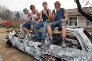
Fire lessons from the Australian capital, where a 2003 inferno changed everything
The residents of Canberra might know a little about what Los Angeles is going through. Exactly 22 years ago, a wildfire became a devastating urban fire in the Australian capital.
On Jan. 18, 2003, what began as a bushfire — as they are known in Australia — started by a lightning strike in the outlying mountain ranges quickly pushed its way ...Read more
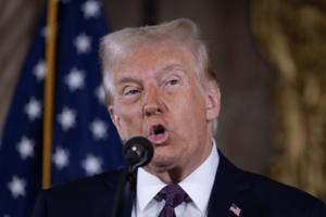
Donald Trump will visit Los Angeles next week to see devastation of wildfires
Donald Trump said he will visit Los Angeles next week after he and Gov. Gavin Newsom sparred for days over California’s response to the wildfires in Ventura and Los Angeles counties.
Trump first announced his plans to visit the Golden State during a rally Sunday in Washington, D.C., a day before he is due to be sworn in as president.
“I ...Read more

UK facing threat of Trump tariffs braces for 'all scenarios'
Prime Minister Keir Starmer is preparing for all eventualities as the U.S. presidency changes hands on Monday with the incoming administration of Donald Trump threatening to slap tariffs on trade with the rest of the world.
Trump has repeatedly vowed to impose tariffs of as much as 20% on imports to the U.S., with even higher rates levied on ...Read more

Gaza ceasefire takes hold as hostages and prisoners are swapped
A long-delayed ceasefire in the Gaza war began taking hold as Hamas released three hostages in exchange for 90 Palestinians held in Israeli prisons.
The first halt in the war since November 2023 appeared to go as planned, following months of negotiations by the Biden administration, along with Qatar and Egypt, then a recent push by President-...Read more
More than a century after mail fraud conviction, Marcus Garvey gets presidential pardon
For over a century, civil rights leader Marcus Mosiah Garvey was demonized, misunderstood and left to the interpretations of the history books after being convicted of mail fraud in 1923 and sentenced to five years’ imprisonment by a federal court in the United States.
Now, the Jamaican-born black nationalist who led the largest economic and ...Read more
He pulled up to Palisades fire with a fire engine and an offer to help. It was fake, police say
The fire truck pulled up to a checkpoint Saturday morning near where emergency workers were sifting through the wreckage caused by the Palisades fire.
The driver told the National Guard troops manning the perimeter that he was a volunteer firefighter, a law enforcement source with knowledge of the incident told The Times.
They had little ...Read more

Georgia prepares for Trump's return to power
WASHINGTON — As Donald Trump prepared to cap a remarkable comeback with a swearing-in ceremony Monday, Georgia leaders from both sides of the aisle braced for a flurry of executive orders and a new political landscape dominated by the once-and-future president’s MAGA movement.
Four years after he left the nation’s capital in disgrace, ...Read more

California high-speed rail: Why 2025 could make or break embattled bullet train project
Fresno and the San Joaquin Valley are at the epicenter of high-speed rail development in California, as construction lumbers ahead on a 119-mile stretch from the northern fringe of Madera to the Kern County community of Shafter.
And leaders in Fresno, Merced and Bakersfield have high hopes for what the rail line — and the stations that will ...Read more
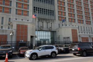
MDC Brooklyn federal jail has just two doctors on staff, hearing reveals
The troubled Metropolitan Detention Center jail in Brooklyn has just two doctors on staff to care for its more than 1,100 inmates, and an opening for a third physician has gone unfilled for nearly a decade.
That detail about the city’s only federal jail — which has long been plagued by delays in medical treatment, missed medical ...Read more

Donald Trump holds campaign-style rally in Washington before inauguration
WASHINGTON — On the eve of his scaled-down second inauguration, President-elect Donald Trump vowed to quickly close the southern border, deport millions of undocumented immigrants and sign a litany of other executive orders when he returns to power on Monday.
“At noon, the curtain closes on four long years of American decline and we begin a...Read more
Massachusetts offshore wind project that Biden visited is no more as Trump retakes office
A $300 million offshore wind cable plant development project in Somerset that President Biden visited in July 2022, ushering in the country’s transition to clean energy, is off the table after its Italian developer walked away from it.
The Prysmian Group backed out of its nearly three-year endeavor of gaining necessary local and state permits...Read more

Minnesota Sen. Amy Klobuchar to call to order Trump's inauguration
Sen. Amy Klobuchar will take the stage Monday to call to order the inauguration of incoming President Donald Trump and incoming Vice President JD Vance.
The Minnesota Democrat chairs the bipartisan Joint Congressional Committee on Inaugural Ceremonies, which is tasked with planning inauguration day. She had planned to speak at the event ...Read more
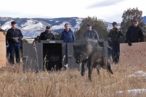
Colorado releases 15 wolves from Canada in second round of historic reintroduction
Colorado wildlife officials released 15 wolves from Canada into the central mountains over the last week as part of the second wave of the state’s historic, voter-mandated reintroduction of the native predator.
Colorado Parks and Wildlife biologists began capturing the wolves on Jan. 10, and agency officials announced Sunday that CPW had ...Read more

Pet monkey jumps through drive-thru window and attacks Starbucks worker, AL cops say
A Starbucks employee was attacked by a customer’s pet monkey, Alabama police say.
The incident happened on Friday, Jan. 10, the Mobile Police Department said in a Jan. 19 email. The animal and its owner were gone by the time officers arrived, but investigators pieced together what happened.
The employee was working the drive-through when a ...Read more

Venezuela's Machado calls on supporters to boycott coming votes
Venezuela’s opposition leader Maria Corina Machado called on her supporters to boycott this year’s regional and parliamentary elections, paving the way for the ruling party to consolidate its control in the country.
“Until the July 28 election results come into effect, it’s not appropriate to participate in elections of any kind,” ...Read more
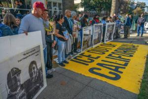
Undocumented Californians brace for Trump's second term. Recent deportations increase fear
Uncertainty about her place in America has followed Jenni Hernandez since before she could remember.
Her mother says Hernandez’s first steps as a baby were crossing the border when the family left their home in Hidalgo, Mexico. When she was as young as 6, her father began warning her about the persistent threat of deportation.
Her anxiety ...Read more
Popular Stories
- First three Israeli hostages freed in Gaza under ceasefire
- Why taking fever-reducing meds and drinking fluids may not be the best way to treat flu and fever
- Trump vows executive order aiding TikTok after app goes dark
- Church without God: How secular congregations fill a need for some nonreligious Americans
- Baltimore's 'Highway to Nowhere' took their homes. Can $85.5 million fix the damage?
Comics