Bear Fire: Northern California blaze grows to 3,000 acres as Sierra County evacuations remain
Published in News & Features
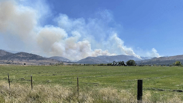
The Bear Fire that has been threatening hundreds of homes in Sierra County this week continued to grow overnight into Wednesday morning as firefighters battled sweltering late summer conditions in rough terrain.
The fire had charred 3,000 acres by Wednesday morning, 1,000 more acres than conditions about 6 p.m. Tuesday, according to the National Interagency Fire Center’s Northern California operations. The fire burning 5 miles south of Loyalton remains 0% contained, firefighters from the U.S. Forest Service and Cal Fire said.
Interagency Management Team 2 — a group of federal, state and local firefighters called in for complex incidents — has been assigned to the fire, joining crews from the Tahoe National Forest and Cal Fire’s Nevada-Yuba-Placer unit.
Tahoe National Forest officials on Tuesday said the combination of warmer temperatures and strong winds intensified the fire while crews were working to establish containment lines. Temperatures in the area are expected to be just short of 90 degrees Wednesday with winds from the east between 5 and 10 mph.
Fire crews were still working to gain access to some areas of the fire due to steep, rocky terrain and limited road access. Planes are being used to drop retardant and water.
As of Tuesday, 286 structures and 536 residents were under evacuation orders while 760 residents were without power. Sierra County officials on Tuesday issued a mandatory water restriction for residents in the area, suspending outdoor watering and asking residents to conserve indoor use as much as possible while crews fight the fire.
Evacuation orders and road closures remain in place for residents of Sierra Brooks and in zones SIE-E030, SIE-E031, SIE-E032, SIE-E058 and SIE-E059. Road closures include Tahoe National Forest System Lands east of Highway 89 and north of County Road 450 at Henness Pass Road. The closure continues north along Highway 89 until the end of National Forest System Lands south of Sierraville.
The closure continues east and north along the boundary of the forest to the Antelope Valley State Wildlife Area and east toward to its junction with the Humboldt-Toiyabe National Forest.
The closure to the south continues along the Tahoe National Forest boundary to the junction of the Truckee Ranger District where the closure boundary goes west along County Road 860 until it becomes County Road 450, back toward Little Truckee Summit.
The blaze began Monday afternoon on the northeastern side of the Tahoe National Forest, roughly 100 miles northeast of Sacramento. The cause of the fire is unknown and under investigation.
____
©2024 The Sacramento Bee. Visit at sacbee.com. Distributed by Tribune Content Agency, LLC.


Comments